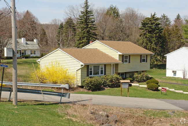
Property Record
17 Romeo Dr, Monroe, NY 10950

Save to a Folder
{{folder.Name}}
{{folder.ListingIds.length}} Properties
{{folder.ListingIds.length}} Property
Create a New Folder
Property Detail
17 Romeo Dr
332089-053-000-0001-023.000-0000
Orange
Residentialacreage
New York
02
23.00
B and X Area of moderate flood hazard, usually the area between the limits of the 100-year and 500-year floods.
1.10 AC
2024
Newburgh
2025
Northern New Jersey
013302
Kiryas Joel-Poughkeepsie-Newburgh, NY
1,056 SF
NEARBY LISTINGS FOR SALE OR LEASE
DEMOGRAPHICS near 17 Romeo Dr
1 mile
3 mile
5 mile
2025 Total Population
5,059
57,668
89,848
2030 Population
5,185
59,557
92,395
Pop Growth 2025-2030
+ 2.49%
+ 3.28%
+ 2.83%
Average Age
24
27
32
2025 Total Households
891
13,094
23,932
HH Growth 2025-2030
+ 3.03%
+ 3.59%
+ 2.88%
Median Household Inc
$64,390
$70,798
$91,167
Avg Household Size
4.90
4.20
3.60
2025 Avg HH Vehicles
1.00
1.00
2.00
Median Home Value
$684,825
$541,601
$479,406
Median Year Built
2004
1993
1985
Nearby Places
Map Layers
Map Styles
 Street
 Aerial
Layers
 Traffic
 Biking
Places
Listings with unknown addresses are not visible on the map
- Restaurants
- Banks
- Shops
- Fitness
- Groceries
PUBLIC TRANSPORTATION
COMMUTER RAIL
Harriman (Port Jervis Line - NJ TRANSIT RAIL)
Drive
Walk
Distance
Harriman (Port Jervis Line - NJ TRANSIT RAIL)
10 min
6.4 mi
Salisbury Mills-Cornwall (Port Jervis Line - NJ TRANSIT RAIL)
Drive
Walk
Distance
Salisbury Mills-Cornwall (Port Jervis Line - NJ TRANSIT RAIL)
18 min
9.9 mi
AIRPORT
New York Stewart International
Drive
Walk
Distance
New York Stewart International
26 min
13.9 mi
Freight Ports
Port Newark Container Terminal
Drive
Walk
Distance
Port Newark Container Terminal
76 min
56.2 mi
Nearby Properties
Address
Land Use
TOTAL SIZE
Lot Size
Zoning
Address
Land Use
TOTAL SIZE
Lot Size
Zoning
31,507 SF
10.50 AC
UR-M
Address
Land Use
TOTAL SIZE
Lot Size
Zoning
31,507 SF
10.50 AC
UR-M
Address
Land Use
TOTAL SIZE
Lot Size
Zoning
8 AC
PD
Address
Land Use
TOTAL SIZE
Lot Size
Zoning
86,696 SF
153.50 AC
A1OP
Address
Land Use
TOTAL SIZE
Lot Size
Zoning
28,934 SF
6.60 AC
PD
Address
Land Use
TOTAL SIZE
Lot Size
Zoning
124,928 SF
12.14 AC
GB
Address
Land Use
TOTAL SIZE
Lot Size
Zoning
70,760 SF
17.20 AC
GB
Address
Land Use
TOTAL SIZE
Lot Size
Zoning
91,472 SF
6.42 AC
SR-10
Address
Land Use
TOTAL SIZE
Lot Size
Zoning
88,240 SF
3.02 AC
R-1
Address
Land Use
TOTAL SIZE
Lot Size
Zoning
113,910 SF
15 AC
PD
Address
Land Use
TOTAL SIZE
Lot Size
Zoning
92,868 SF
1.22 AC
PD
Address
Land Use
TOTAL SIZE
Lot Size
Zoning
98,426 SF
5 AC
PD
Address
Land Use
TOTAL SIZE
Lot Size
Zoning
126,112 SF
3.30 AC
R-1
Address
Land Use
TOTAL SIZE
Lot Size
Zoning
117,855 SF
3.20 AC
PD
Address
Land Use
TOTAL SIZE
Lot Size
Zoning
55,780 SF
64 AC
Address
Land Use
TOTAL SIZE
Lot Size
Zoning
132,928 SF
2.60 AC
PD
Address
Land Use
TOTAL SIZE
Lot Size
Zoning
40,040 SF
13.87 AC
SR-20
Address
Land Use
TOTAL SIZE
Lot Size
Zoning
114,667 SF
22.50 AC
PD
Address
Land Use
TOTAL SIZE
Lot Size
Zoning
120,054 SF
168.80 AC
04
Address
Land Use
TOTAL SIZE
Lot Size
Zoning
172,584 SF
13.40 AC
LI
Address
Land Use
TOTAL SIZE
Lot Size
Zoning
105,554 SF
2.90 AC
R-1
Address
Land Use
TOTAL SIZE
Lot Size
Zoning
60.70 AC
Address
Land Use
TOTAL SIZE
Lot Size
Zoning
82,232 SF
2 AC
PD
Address
Land Use
TOTAL SIZE
Lot Size
Zoning
46,897 SF
18.60 AC
Address
Land Use
TOTAL SIZE
Lot Size
Zoning
107,305 SF
2.80 AC
PD
Address
Land Use
TOTAL SIZE
Lot Size
Zoning
117.60 AC
Address
Land Use
TOTAL SIZE
Lot Size
Zoning
82,716 SF
3.33 AC
PD
Address
Land Use
TOTAL SIZE
Lot Size
Zoning
94,006 SF
3.10 AC
R-2
Address
Land Use
TOTAL SIZE
Lot Size
Zoning
31,224 SF
0.61 AC
R-1
Address
Land Use
TOTAL SIZE
Lot Size
Zoning
86,366 SF
9.39 AC
GB
The World's #1 Commercial Real Estate Marketplace
Connect with us
© 2026 CoStar Group
The information above has been obtained from sources believed reliable. While we do not doubt its accuracy we have not verified it and make no guarantee, warranty or representation about it. It is your responsibility to independently confirm its accuracy and completeness. Any projections, opinions, assumptions, or estimates used are for example only and do not represent the current or future performance of the property. The value of this transaction to you depends on tax and other factors which should be evaluated by your tax, financial, and legal advisors. You and your advisors should conduct a careful, independent investigation of the property to determine to your satisfaction the suitability of the property for your needs.