Property Record
17 S Highway Hwy S, Chocowinity, NC 27817
NEARBY LISTINGS FOR SALE OR LEASE
Property Detail
17 S Highway Hwy S
Washington, NC
Wynn
5675-34-8651
4 LOTS #30 THRU 33 KUGLER AND WYNN SD
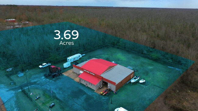
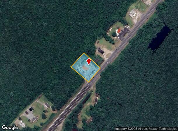
Autorepair
Beaufort
AE
North Carolina
3720567500K
30-33
2025
1.19 AC
2025
North Carolina Northeast Area
931002
Other Market Areas
4,580 SF
DEMOGRAPHICS near 17 S Highway Hwy S
1 Mile
3 Mile
5 Mile
2024 Total Population
175
11,694
21,794
2029 Population
173
11,607
21,611
Pop Growth 2024-2029
(1.14%)
(0.74%)
(0.84%)
Average Age
44
45
44
2024 Total Households
81
5,227
9,433
HH Growth 2024-2029
(1.23%)
(0.73%)
(0.85%)
Median Household Inc
$34,999
$39,311
$42,610
Avg Household Size
2.10
2.20
2.30
2024 Avg HH Vehicles
2.00
2.00
2.00
Median Home Value
$214,286
$196,964
$159,133
Median Year Built
1975
1973
1978
Nearby Places
Map Layers
Map Styles
 Street
 Aerial
- Restaurants
- Banks
- Shops
- Fitness
- Groceries
PUBLIC TRANSPORTATION
AIRPORT
Pitt-Greenville
DRIVE
WALK
Distance
Pitt-Greenville
37 min
24.8 mi
Freight Ports
Port of Morehead City
DRIVE
WALK
Distance
Port of Morehead City
108 min
75.3 mi
SALE & LEASE HISTORY
LISTING DATE
SALE/LEASE

Dec 28, 2018
For Sale
Nearby Properties
Address
Land Use
TOTAL SIZE
Lot Size
Zoning
Address
Land Use
TOTAL SIZE
Lot Size
Zoning
119,607 SF
10 AC
Address
Land Use
TOTAL SIZE
Lot Size
Zoning
4,597 SF
18.58 AC
B3
Address
Land Use
TOTAL SIZE
Lot Size
Zoning
190,121 SF
15.77 AC
Address
Land Use
TOTAL SIZE
Lot Size
Zoning
533 SF
17.45 AC
R8
Address
Land Use
TOTAL SIZE
Lot Size
Zoning
152,940 SF
35.41 AC
B2
Address
Land Use
TOTAL SIZE
Lot Size
Zoning
28.49 AC
Address
Land Use
TOTAL SIZE
Lot Size
Zoning
297,021 SF
28.85 AC
L1
Address
Land Use
TOTAL SIZE
Lot Size
Zoning
43,310 SF
4.86 AC
Address
Land Use
TOTAL SIZE
Lot Size
Zoning
90,294 SF
14.42 AC
B3
Address
Land Use
TOTAL SIZE
Lot Size
Zoning
3.51 AC
Address
Land Use
TOTAL SIZE
Lot Size
Zoning
51,300 SF
1.41 AC
Address
Land Use
TOTAL SIZE
Lot Size
Zoning
12,167 SF
39.81 AC
Address
Land Use
TOTAL SIZE
Lot Size
Zoning
3,142 SF
12.97 AC
R6
Address
Land Use
TOTAL SIZE
Lot Size
Zoning
9,728 SF
20.03 AC
R6
Address
Land Use
TOTAL SIZE
Lot Size
Zoning
4.39 AC
B2
Address
Land Use
TOTAL SIZE
Lot Size
Zoning
100,608 SF
10.03 AC
B3
Address
Land Use
TOTAL SIZE
Lot Size
Zoning
43,535 SF
18.83 AC
Address
Land Use
TOTAL SIZE
Lot Size
Zoning
24,752 SF
4.70 AC
OI
Address
Land Use
TOTAL SIZE
Lot Size
Zoning
2.11 AC
B2
Address
Land Use
TOTAL SIZE
Lot Size
Zoning
14,500 SF
12.50 AC
R6S
Address
Land Use
TOTAL SIZE
Lot Size
Zoning
4,310 SF
118.29 AC
Address
Land Use
TOTAL SIZE
Lot Size
Zoning
39,622 SF
2.68 AC
Address
Land Use
TOTAL SIZE
Lot Size
Zoning
131,025 SF
45.57 AC
I2
Address
Land Use
TOTAL SIZE
Lot Size
Zoning
45,707 SF
19.80 AC
Address
Land Use
TOTAL SIZE
Lot Size
Zoning
5.46 AC
OI
Address
Land Use
TOTAL SIZE
Lot Size
Zoning
29,496 SF
13.35 AC
RA20
Address
Land Use
TOTAL SIZE
Lot Size
Zoning
2,270 SF
22.08 AC
Address
Land Use
TOTAL SIZE
Lot Size
Zoning
30,328 SF
1.24 AC
B1H
Address
Land Use
TOTAL SIZE
Lot Size
Zoning
27,864 SF
0.92 AC
RHD
Address
Land Use
TOTAL SIZE
Lot Size
Zoning
17,640 SF
1.78 AC
OI
The World's #1 Commercial Real Estate Marketplace
Connect with us
© 2025 CoStar Group
The information above has been obtained from sources believed reliable. While we do not doubt its accuracy we have not verified it and make no guarantee, warranty or representation about it. It is your responsibility to independently confirm its accuracy and completeness. Any projections, opinions, assumptions, or estimates used are for example only and do not represent the current or future performance of the property. The value of this transaction to you depends on tax and other factors which should be evaluated by your tax, financial, and legal advisors. You and your advisors should conduct a careful, independent investigation of the property to determine to your satisfaction the suitability of the property for your needs.