Property Record
17 Wilson Rd, Cumberland Center, ME 04021
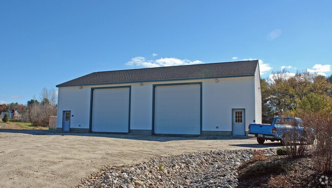

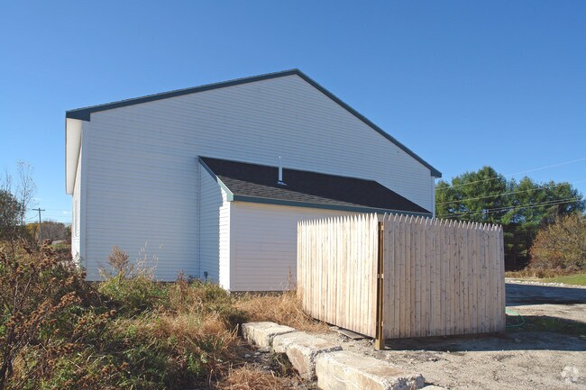
Property Detail
17 Wilson Rd
CMBL-000007C-R000000-000016
CUMBERLAND
Commercialbuilding
Maine
VOC1
16
B and X Area of moderate flood hazard, usually the area between the limits of the 100-year and 500-year floods.
2.60 AC
2025
NE Cumberland County
2025
Portland/South Portland
004201
Portland-South Portland, ME
2,720 SF
NEARBY LISTINGS FOR SALE OR LEASE
-
-
View all Cumberland Center listings for sale on LoopNet.com
DEMOGRAPHICS near 17 Wilson Rd
1 mile
3 mile
5 mile
2025 Total Population
960
7,125
20,689
2030 Population
970
7,174
20,937
Pop Growth 2025-2030
+ 1.04%
+ 0.69%
+ 1.20%
Average Age
39
41
42
2025 Total Households
350
2,643
7,826
HH Growth 2025-2030
+ 1.14%
+ 0.83%
+ 1.35%
Median Household Inc
$135,887
$134,400
$128,646
Avg Household Size
2.80
2.70
2.60
2025 Avg HH Vehicles
3.00
2.00
2.00
Median Home Value
$621,173
$587,683
$518,877
Median Year Built
1990
1987
1986
Nearby Places
Map Layers
Map Styles
 Street
 Aerial
Layers
 Traffic
 Biking
Places
Listings with unknown addresses are not visible on the map
- Restaurants
- Banks
- Shops
- Fitness
- Groceries
PUBLIC TRANSPORTATION
AIRPORT
Portland International Jetport
Drive
Walk
Distance
Portland International Jetport
24 min
13.3 mi
Freight Ports
Portland, ME
Drive
Walk
Distance
Portland, ME
23 min
12.1 mi
Nearby Properties
Address
Land Use
TOTAL SIZE
Lot Size
Zoning
Address
Land Use
TOTAL SIZE
Lot Size
Zoning
9.50 AC
MDR
Address
Land Use
TOTAL SIZE
Lot Size
Zoning
45.63 AC
RR2
Address
Land Use
TOTAL SIZE
Lot Size
Zoning
75,148 SF
19.91 AC
MDR
Address
Land Use
TOTAL SIZE
Lot Size
Zoning
190 AC
FFM
Address
Land Use
TOTAL SIZE
Lot Size
Zoning
22.42 AC
LDR
Address
Land Use
TOTAL SIZE
Lot Size
Zoning
10,861 SF
7.59 AC
FFM
Address
Land Use
TOTAL SIZE
Lot Size
Zoning
20,376 SF
1.98 AC
VCC
Address
Land Use
TOTAL SIZE
Lot Size
Zoning
32,614 SF
4.17 AC
OC-S
Address
Land Use
TOTAL SIZE
Lot Size
Zoning
8 AC
MDR
Address
Land Use
TOTAL SIZE
Lot Size
Zoning
84.99 AC
Address
Land Use
TOTAL SIZE
Lot Size
Zoning
14,130 SF
0.55 AC
MDR
Address
Land Use
TOTAL SIZE
Lot Size
Zoning
7,500 SF
2.55 AC
OC
Address
Land Use
TOTAL SIZE
Lot Size
Zoning
11,037 SF
2.13 AC
OC
Address
Land Use
TOTAL SIZE
Lot Size
Zoning
10,125 SF
6 AC
OC
Address
Land Use
TOTAL SIZE
Lot Size
Zoning
8,169 SF
5.92 AC
RR1
Address
Land Use
TOTAL SIZE
Lot Size
Zoning
293 AC
FF
Address
Land Use
TOTAL SIZE
Lot Size
Zoning
7,173 SF
4 AC
RURAL
Address
Land Use
TOTAL SIZE
Lot Size
Zoning
6,294 SF
7 AC
6015
Address
Land Use
TOTAL SIZE
Lot Size
Zoning
4,042 SF
48.27 AC
FFM
Address
Land Use
TOTAL SIZE
Lot Size
Zoning
12,517 SF
8.30 AC
VCC
Address
Land Use
TOTAL SIZE
Lot Size
Zoning
6.25 AC
VMDR
Address
Land Use
TOTAL SIZE
Lot Size
Zoning
3.70 AC
MEDIUM
Address
Land Use
TOTAL SIZE
Lot Size
Zoning
5 AC
RA
Address
Land Use
TOTAL SIZE
Lot Size
Zoning
11,900 SF
4.40 AC
RI
Address
Land Use
TOTAL SIZE
Lot Size
Zoning
13,637 SF
0.81 AC
TCD
Address
Land Use
TOTAL SIZE
Lot Size
Zoning
5,160 SF
2.70 AC
OC
Address
Land Use
TOTAL SIZE
Lot Size
Zoning
5,856 SF
5.79 AC
1
Address
Land Use
TOTAL SIZE
Lot Size
Zoning
8,930 SF
0.87 AC
TCD
Address
Land Use
TOTAL SIZE
Lot Size
Zoning
1 AC
RURAL
Address
Land Use
TOTAL SIZE
Lot Size
Zoning
7.93 AC
RR2
The World's #1 Commercial Real Estate Marketplace
Connect with us
© 2026 CoStar Group
The information above has been obtained from sources believed reliable. While we do not doubt its accuracy we have not verified it and make no guarantee, warranty or representation about it. It is your responsibility to independently confirm its accuracy and completeness. Any projections, opinions, assumptions, or estimates used are for example only and do not represent the current or future performance of the property. The value of this transaction to you depends on tax and other factors which should be evaluated by your tax, financial, and legal advisors. You and your advisors should conduct a careful, independent investigation of the property to determine to your satisfaction the suitability of the property for your needs.