Property Record
170 Burnham St, Berlin, CT 06037
NEARBY LISTINGS FOR SALE OR LEASE
-
-
View all Berlin listings for sale on LoopNet.com
Property Detail
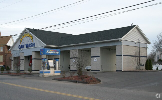
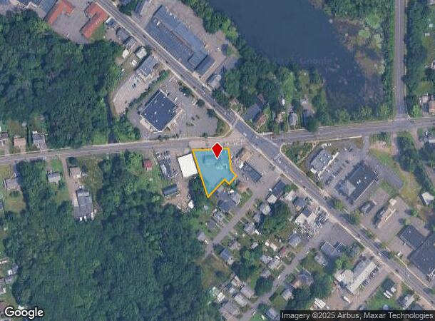
170 Burnham St
BERL-000094-000091-000008
Hartford
Carwash
Connecticut
AE
8
09003C0494F
0.48 AC
2025
Berlin Outlying
2025
Hartford
400300
Hartford-West Hartford-East Hartford, CT
2,812 SF
DEMOGRAPHICS near 170 Burnham St
1 Mile
3 Mile
5 Mile
2024 Total Population
4,565
49,135
141,447
2029 Population
4,509
48,481
140,270
Pop Growth 2024-2029
(1.23%)
(1.33%)
(0.83%)
Average Age
44
41
40
2024 Total Households
1,948
19,759
57,003
HH Growth 2024-2029
(1.23%)
(1.32%)
(0.84%)
Median Household Inc
$89,583
$68,094
$73,734
Avg Household Size
2.30
2.40
2.40
2024 Avg HH Vehicles
2.00
2.00
2.00
Median Home Value
$255,103
$270,905
$254,126
Median Year Built
1961
1960
1967
Nearby Places
Map Layers
Map Styles
 Street
 Aerial
- Restaurants
- Banks
- Shops
- Fitness
- Groceries
PUBLIC TRANSPORTATION
COMMUTER RAIL
DRIVE
WALK
Distance
2 min
8 min
0.4 mi
DRIVE
WALK
Distance
2 min
10 min
0.4 mi
AIRPORT
Bradley International
DRIVE
WALK
Distance
Bradley International
42 min
27.1 mi
Tweed/New Haven
DRIVE
WALK
Distance
Tweed/New Haven
44 min
29.8 mi
Freight Ports
Port of New Haven
DRIVE
WALK
Distance
Port of New Haven
39 min
28.6 mi
Nearby Properties
Address
Land Use
TOTAL SIZE
Lot Size
Zoning
Address
Land Use
TOTAL SIZE
Lot Size
Zoning
109,079 SF
110.62 AC
OT
Address
Land Use
TOTAL SIZE
Lot Size
Zoning
138.27 AC
S1
Address
Land Use
TOTAL SIZE
Lot Size
Zoning
2.07 AC
CBD
Address
Land Use
TOTAL SIZE
Lot Size
Zoning
90,625 SF
0.97 AC
CBD
Address
Land Use
TOTAL SIZE
Lot Size
Zoning
241,225 SF
25.64 AC
R-11
Address
Land Use
TOTAL SIZE
Lot Size
Zoning
96,238 SF
6.75 AC
T
Address
Land Use
TOTAL SIZE
Lot Size
Zoning
2.46 AC
CBD
Address
Land Use
TOTAL SIZE
Lot Size
Zoning
33.36 AC
T
Address
Land Use
TOTAL SIZE
Lot Size
Zoning
78,109 SF
8.22 AC
T
Address
Land Use
TOTAL SIZE
Lot Size
Zoning
89,544 SF
6.20 AC
S1
Address
Land Use
TOTAL SIZE
Lot Size
Zoning
21.35 AC
PD
Address
Land Use
TOTAL SIZE
Lot Size
Zoning
68 AC
R-20
Address
Land Use
TOTAL SIZE
Lot Size
Zoning
74,670 SF
4.46 AC
S2
Address
Land Use
TOTAL SIZE
Lot Size
Zoning
5.20 AC
PD
Address
Land Use
TOTAL SIZE
Lot Size
Zoning
38,860 SF
38.47 AC
PS-B
Address
Land Use
TOTAL SIZE
Lot Size
Zoning
83,464 SF
13.96 AC
T
Address
Land Use
TOTAL SIZE
Lot Size
Zoning
185,902 SF
101.89 AC
GI-2
Address
Land Use
TOTAL SIZE
Lot Size
Zoning
76,510 SF
10 AC
R-11
Address
Land Use
TOTAL SIZE
Lot Size
Zoning
18.53 AC
BTD
Address
Land Use
TOTAL SIZE
Lot Size
Zoning
91,663 SF
22.20 AC
R-21
Address
Land Use
TOTAL SIZE
Lot Size
Zoning
2 AC
OP
Address
Land Use
TOTAL SIZE
Lot Size
Zoning
12.53 AC
CBD
Address
Land Use
TOTAL SIZE
Lot Size
Zoning
10.76 AC
PD
Address
Land Use
TOTAL SIZE
Lot Size
Zoning
44,084 SF
1.36 AC
T
Address
Land Use
TOTAL SIZE
Lot Size
Zoning
5.03 AC
OP
Address
Land Use
TOTAL SIZE
Lot Size
Zoning
25.10 AC
R-15
Address
Land Use
TOTAL SIZE
Lot Size
Zoning
125,492 SF
12.39 AC
PD
Address
Land Use
TOTAL SIZE
Lot Size
Zoning
133,946 SF
18.32 AC
PD
Address
Land Use
TOTAL SIZE
Lot Size
Zoning
133,290 SF
11.64 AC
PD
Address
Land Use
TOTAL SIZE
Lot Size
Zoning
67,050 SF
20.36 AC
R-15
The World's #1 Commercial Real Estate Marketplace
Connect with us
© 2026 CoStar Group
The information above has been obtained from sources believed reliable. While we do not doubt its accuracy we have not verified it and make no guarantee, warranty or representation about it. It is your responsibility to independently confirm its accuracy and completeness. Any projections, opinions, assumptions, or estimates used are for example only and do not represent the current or future performance of the property. The value of this transaction to you depends on tax and other factors which should be evaluated by your tax, financial, and legal advisors. You and your advisors should conduct a careful, independent investigation of the property to determine to your satisfaction the suitability of the property for your needs.