Property Record
170 Clay Pond Rd, Buzzards Bay, MA 02532


Save to a Folder
{{folder.Name}}
{{folder.ListingIds.length}} Properties
{{folder.ListingIds.length}} Property
Create a New Folder
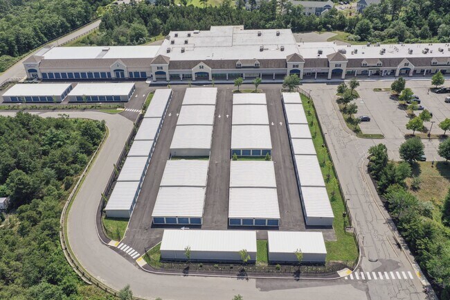
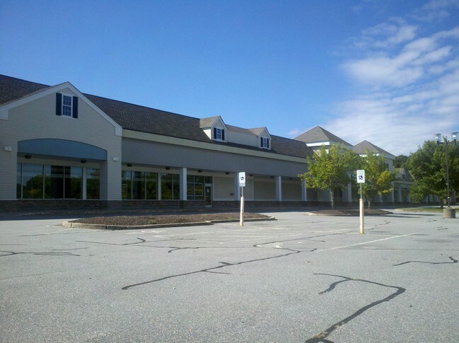
Property Detail
170 Clay Pond Rd
BOUR-000314-000000-000020
Barnstable
Taxexempt
Massachusetts
B and X Area of moderate flood hazard, usually the area between the limits of the 100-year and 500-year floods.
16.18 AC
2025
Cape Cod
2025
Other Market Areas
014002
Barnstable Town, MA
56,538 SF
NEARBY LISTINGS FOR SALE OR LEASE
-
-
View all Buzzards Bay listings for lease on LoopNet.com
DEMOGRAPHICS near 170 Clay Pond Rd
1 mile
3 mile
5 mile
2025 Total Population
1,478
10,168
26,168
2030 Population
1,385
9,818
25,591
Pop Growth 2025-2030
(6.29%)
(3.44%)
(2.20%)
Average Age
50
47
47
2025 Total Households
689
4,289
10,842
HH Growth 2025-2030
(6.68%)
(3.89%)
(2.48%)
Median Household Inc
$95,833
$93,369
$93,232
Avg Household Size
2.10
2.10
2.20
2025 Avg HH Vehicles
2.00
2.00
2.00
Median Home Value
$587,156
$602,707
$523,879
Median Year Built
1982
1975
1973
Nearby Places
Map Layers
Map Styles
 Street
 Aerial
Layers
 Traffic
 Biking
Places
Listings with unknown addresses are not visible on the map
- Restaurants
- Banks
- Shops
- Fitness
- Groceries
PUBLIC TRANSPORTATION
COMMUTER RAIL
Drive
Walk
Distance
6 min
3.1 mi
Drive
Walk
Distance
12 min
6.1 mi
AIRPORT
Martha's Vineyard
Drive
Walk
Distance
Martha's Vineyard
87 min
29.4 mi
Freight Ports
Port of New Bedford Harbor
Drive
Walk
Distance
Port of New Bedford Harbor
41 min
30.4 mi
SALE & LEASE HISTORY
LISTING DATE
SALE/LEASE

Sep 25, 2016
For Lease
Sep 25, 2016
For Lease
Oct 29, 2020
For Lease
Nov 07, 2019
For Lease
Nov 04, 2016
For Lease
Nearby Properties
Address
Land Use
TOTAL SIZE
Lot Size
Zoning
Address
Land Use
TOTAL SIZE
Lot Size
Zoning
18.82 AC
R40
Address
Land Use
TOTAL SIZE
Lot Size
Zoning
75.70 AC
R40
Address
Land Use
TOTAL SIZE
Lot Size
Zoning
1,758 SF
269.51 AC
R40
Address
Land Use
TOTAL SIZE
Lot Size
Zoning
106,987 SF
3.95 AC
Address
Land Use
TOTAL SIZE
Lot Size
Zoning
46 AC
R40
Address
Land Use
TOTAL SIZE
Lot Size
Zoning
22,000 SF
749.29 AC
GD
Address
Land Use
TOTAL SIZE
Lot Size
Zoning
15,716 SF
7.85 AC
R40
Address
Land Use
TOTAL SIZE
Lot Size
Zoning
35,732 SF
289.94 AC
R40
Address
Land Use
TOTAL SIZE
Lot Size
Zoning
73,483 SF
16.18 AC
Address
Land Use
TOTAL SIZE
Lot Size
Zoning
67,216 SF
2.70 AC
DTD
Address
Land Use
TOTAL SIZE
Lot Size
Zoning
74.05 AC
B-3
Address
Land Use
TOTAL SIZE
Lot Size
Zoning
68.53 AC
R40
Address
Land Use
TOTAL SIZE
Lot Size
Zoning
125,493 SF
5.59 AC
DTD
Address
Land Use
TOTAL SIZE
Lot Size
Zoning
27,958 SF
5.85 AC
R40
Address
Land Use
TOTAL SIZE
Lot Size
Zoning
57,942 SF
7.20 AC
Address
Land Use
TOTAL SIZE
Lot Size
Zoning
4,214 SF
13.85 AC
Address
Land Use
TOTAL SIZE
Lot Size
Zoning
45.85 AC
Address
Land Use
TOTAL SIZE
Lot Size
Zoning
26,053 SF
1.26 AC
Address
Land Use
TOTAL SIZE
Lot Size
Zoning
2.82 AC
Address
Land Use
TOTAL SIZE
Lot Size
Zoning
1,452 SF
6.70 AC
Address
Land Use
TOTAL SIZE
Lot Size
Zoning
15.80 AC
Address
Land Use
TOTAL SIZE
Lot Size
Zoning
Address
Land Use
TOTAL SIZE
Lot Size
Zoning
24,100 SF
3.03 AC
Address
Land Use
TOTAL SIZE
Lot Size
Zoning
2,024 SF
10.57 AC
R40
Address
Land Use
TOTAL SIZE
Lot Size
Zoning
Address
Land Use
TOTAL SIZE
Lot Size
Zoning
10.02 AC
R40
Address
Land Use
TOTAL SIZE
Lot Size
Zoning
2.44 AC
R40
Address
Land Use
TOTAL SIZE
Lot Size
Zoning
7,856 SF
5.34 AC
R40
Address
Land Use
TOTAL SIZE
Lot Size
Zoning
38,800 SF
5.24 AC
B-4
Address
Land Use
TOTAL SIZE
Lot Size
Zoning
2.70 AC
R40
The World's #1 Commercial Real Estate Marketplace
Connect with us
© 2026 CoStar Group
The information above has been obtained from sources believed reliable. While we do not doubt its accuracy we have not verified it and make no guarantee, warranty or representation about it. It is your responsibility to independently confirm its accuracy and completeness. Any projections, opinions, assumptions, or estimates used are for example only and do not represent the current or future performance of the property. The value of this transaction to you depends on tax and other factors which should be evaluated by your tax, financial, and legal advisors. You and your advisors should conduct a careful, independent investigation of the property to determine to your satisfaction the suitability of the property for your needs.