Property Record
Epping Rd, Exeter, NH 03833
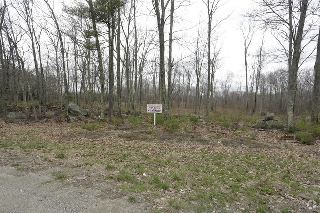

This Property Is For Sale
Property Detail
Epping Rd
EXTR-000047-000000-000007
ROCKINGHAM
Commercialacreage
New Hampshire
C-3
7
A Areas with a 1% annual chance of flooding and a 26% chance of flooding over the life of a 30-year mortgage.
14.46 AC
2025
Rockingham
2025
Boston
061001
Boston-Cambridge-Newton, MA-NH
NEARBY LISTINGS FOR SALE OR LEASE
-
-
View all Exeter listings for sale on LoopNet.com
DEMOGRAPHICS near Epping Rd
1 mile
3 mile
5 mile
2025 Total Population
2,034
16,788
33,277
2030 Population
2,094
17,077
33,671
Pop Growth 2025-2030
+ 2.95%
+ 1.72%
+ 1.18%
Average Age
42
45
45
2025 Total Households
848
7,070
13,389
HH Growth 2025-2030
+ 2.83%
+ 1.57%
+ 1.11%
Median Household Inc
$96,582
$100,299
$115,505
Avg Household Size
2.40
2.30
2.40
2025 Avg HH Vehicles
2.00
2.00
2.00
Median Home Value
$575,384
$528,899
$589,240
Median Year Built
1981
1980
1984
Nearby Places
Map Layers
Map Styles
 Street
 Aerial
Transit
 Traffic
 Biking
Places
Listings with unknown addresses are not visible on the map
- Restaurants
- Banks
- Shops
- Fitness
- Groceries
Nearby Properties
Address
Land Use
TOTAL SIZE
Lot Size
Zoning
Address
Land Use
TOTAL SIZE
Lot Size
Zoning
331,064 SF
120.31 AC
RU
Address
Land Use
TOTAL SIZE
Lot Size
Zoning
62,244 SF
205.33 AC
R-1
Address
Land Use
TOTAL SIZE
Lot Size
Zoning
19,956 SF
14.55 AC
H
Address
Land Use
TOTAL SIZE
Lot Size
Zoning
7.36 AC
R-2
Address
Land Use
TOTAL SIZE
Lot Size
Zoning
19,195 SF
21 AC
R-2
Address
Land Use
TOTAL SIZE
Lot Size
Zoning
12,487 SF
7.01 AC
R-5
Address
Land Use
TOTAL SIZE
Lot Size
Zoning
22,614 SF
11.07 AC
R-2
Address
Land Use
TOTAL SIZE
Lot Size
Zoning
1.20 AC
H
Address
Land Use
TOTAL SIZE
Lot Size
Zoning
29,073 SF
1.14 AC
R-2
Address
Land Use
TOTAL SIZE
Lot Size
Zoning
48,348 SF
8.60 AC
R-5
Address
Land Use
TOTAL SIZE
Lot Size
Zoning
62,244 SF
196.90 AC
R-1
Address
Land Use
TOTAL SIZE
Lot Size
Zoning
29,073 SF
13.46 AC
R-2
Address
Land Use
TOTAL SIZE
Lot Size
Zoning
0.88 AC
R-2
Address
Land Use
TOTAL SIZE
Lot Size
Zoning
53,360 SF
1.54 AC
C-2
Address
Land Use
TOTAL SIZE
Lot Size
Zoning
2,700 SF
88.89 AC
M
Address
Land Use
TOTAL SIZE
Lot Size
Zoning
84,479 SF
18.74 AC
CT-1
Address
Land Use
TOTAL SIZE
Lot Size
Zoning
20,593 SF
19.83 AC
R-2
Address
Land Use
TOTAL SIZE
Lot Size
Zoning
64,221 SF
11.70 AC
H
Address
Land Use
TOTAL SIZE
Lot Size
Zoning
22,614 SF
0.29 AC
R-2
Address
Land Use
TOTAL SIZE
Lot Size
Zoning
792 SF
49.28 AC
M
Address
Land Use
TOTAL SIZE
Lot Size
Zoning
245,000 SF
6.35 AC
H
Address
Land Use
TOTAL SIZE
Lot Size
Zoning
72,932 SF
43.83 AC
GCBD
Address
Land Use
TOTAL SIZE
Lot Size
Zoning
160,616 SF
9.03 AC
C-2
Address
Land Use
TOTAL SIZE
Lot Size
Zoning
73,282 SF
15.79 AC
GCBD
Address
Land Use
TOTAL SIZE
Lot Size
Zoning
46,512 SF
1 AC
H
Address
Land Use
TOTAL SIZE
Lot Size
Zoning
69,700 SF
2.46 AC
C-2
Address
Land Use
TOTAL SIZE
Lot Size
Zoning
65,131 SF
8.96 AC
C-2
Address
Land Use
TOTAL SIZE
Lot Size
Zoning
0.64 AC
R-2
Address
Land Use
TOTAL SIZE
Lot Size
Zoning
106,476 SF
20.35 AC
CT-1
Address
Land Use
TOTAL SIZE
Lot Size
Zoning
329,504 SF
30 AC
I - IN
The World's #1 Commercial Real Estate Marketplace
Connect with us
© 2026 CoStar Group
The information above has been obtained from sources believed reliable. While we do not doubt its accuracy we have not verified it and make no guarantee, warranty or representation about it. It is your responsibility to independently confirm its accuracy and completeness. Any projections, opinions, assumptions, or estimates used are for example only and do not represent the current or future performance of the property. The value of this transaction to you depends on tax and other factors which should be evaluated by your tax, financial, and legal advisors. You and your advisors should conduct a careful, independent investigation of the property to determine to your satisfaction the suitability of the property for your needs.