Property Record
170 Flair Fold Dr, Lumberton, NC 28360

NEARBY LISTINGS FOR SALE OR LEASE
-
-
View all Lumberton listings for sale on LoopNet.com
Property Detail
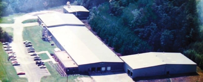
170 Flair Fold Dr
Lightindustrial
AC N/W SCL RR S/W SMITH REFRIGERATION
X
Robeson
3710937200K
North Carolina
2025
9.38 AC
2025
Other Market Areas
961200
Lumberton, NC
49,984 SF
1607-02-00302
DEMOGRAPHICS near 170 Flair Fold Dr
1 Mile
3 Mile
5 Mile
2024 Total Population
234
4,228
9,151
2029 Population
232
4,254
9,129
Pop Growth 2024-2029
(0.85%)
+ 0.61%
(0.24%)
Average Age
39
39
39
2024 Total Households
85
1,412
2,821
HH Growth 2024-2029
0.00%
+ 0.78%
(0.21%)
Median Household Inc
$39,999
$26,169
$33,834
Avg Household Size
2.70
2.50
2.60
2024 Avg HH Vehicles
2.00
2.00
2.00
Median Home Value
$69,230
$70,672
$72,352
Median Year Built
1989
1981
1983
Nearby Places
Map Layers
Map Styles
 Street
 Aerial
- Restaurants
- Banks
- Shops
- Fitness
- Groceries
PUBLIC TRANSPORTATION
AIRPORT
Fayetteville Regional/Grannis Field
DRIVE
WALK
Distance
Fayetteville Regional/Grannis Field
40 min
31.7 mi
Freight Ports
Port of Wilmington
DRIVE
WALK
Distance
Port of Wilmington
112 min
87.2 mi
Nearby Properties
Address
Land Use
TOTAL SIZE
Lot Size
Zoning
Address
Land Use
TOTAL SIZE
Lot Size
Zoning
234,074 SF
63.48 AC
M2
Address
Land Use
TOTAL SIZE
Lot Size
Zoning
10,197 SF
417.66 AC
M1
Address
Land Use
TOTAL SIZE
Lot Size
Zoning
39,628 SF
34.85 AC
M2
Address
Land Use
TOTAL SIZE
Lot Size
Zoning
418,000 SF
31.52 AC
M2
Address
Land Use
TOTAL SIZE
Lot Size
Zoning
1,650 SF
26.34 AC
RA
Address
Land Use
TOTAL SIZE
Lot Size
Zoning
106,046 SF
31.24 AC
RA
Address
Land Use
TOTAL SIZE
Lot Size
Zoning
158,379 SF
17.47 AC
I2
Address
Land Use
TOTAL SIZE
Lot Size
Zoning
1,894 SF
11.48 AC
R3
Address
Land Use
TOTAL SIZE
Lot Size
Zoning
71,260 SF
7.69 AC
B4
Address
Land Use
TOTAL SIZE
Lot Size
Zoning
298,644 SF
18.37 AC
I2
Address
Land Use
TOTAL SIZE
Lot Size
Zoning
118,875 SF
7.17 AC
M1
Address
Land Use
TOTAL SIZE
Lot Size
Zoning
30,000 SF
11.31 AC
A
Address
Land Use
TOTAL SIZE
Lot Size
Zoning
173,232 SF
13.83 AC
M2
Address
Land Use
TOTAL SIZE
Lot Size
Zoning
134,250 SF
56.70 AC
M2
Address
Land Use
TOTAL SIZE
Lot Size
Zoning
24,000 SF
14.45 AC
Address
Land Use
TOTAL SIZE
Lot Size
Zoning
26,508 SF
9.88 AC
Address
Land Use
TOTAL SIZE
Lot Size
Zoning
24,511 SF
40 AC
I2
Address
Land Use
TOTAL SIZE
Lot Size
Zoning
260,616 SF
10.35 AC
M2
Address
Land Use
TOTAL SIZE
Lot Size
Zoning
9,439 SF
6.40 AC
Address
Land Use
TOTAL SIZE
Lot Size
Zoning
25,056 SF
6.76 AC
Address
Land Use
TOTAL SIZE
Lot Size
Zoning
117,880 SF
6.24 AC
I2
Address
Land Use
TOTAL SIZE
Lot Size
Zoning
24,658 SF
2.98 AC
Address
Land Use
TOTAL SIZE
Lot Size
Zoning
5,675 SF
1.76 AC
B4
Address
Land Use
TOTAL SIZE
Lot Size
Zoning
12,960 SF
75.29 AC
Address
Land Use
TOTAL SIZE
Lot Size
Zoning
149,575 SF
28.83 AC
M2
Address
Land Use
TOTAL SIZE
Lot Size
Zoning
20,000 SF
8.85 AC
M2
Address
Land Use
TOTAL SIZE
Lot Size
Zoning
5,370 SF
2.11 AC
B4
Address
Land Use
TOTAL SIZE
Lot Size
Zoning
19,440 SF
19.73 AC
R20
Address
Land Use
TOTAL SIZE
Lot Size
Zoning
18,000 SF
2.17 AC
B4
Address
Land Use
TOTAL SIZE
Lot Size
Zoning
100,000 SF
9.35 AC
R20
The World's #1 Commercial Real Estate Marketplace
Connect with us
© 2025 CoStar Group
The information above has been obtained from sources believed reliable. While we do not doubt its accuracy we have not verified it and make no guarantee, warranty or representation about it. It is your responsibility to independently confirm its accuracy and completeness. Any projections, opinions, assumptions, or estimates used are for example only and do not represent the current or future performance of the property. The value of this transaction to you depends on tax and other factors which should be evaluated by your tax, financial, and legal advisors. You and your advisors should conduct a careful, independent investigation of the property to determine to your satisfaction the suitability of the property for your needs.