Property Record
170 N Church St, Asheboro, NC 27203

NEARBY LISTINGS FOR SALE OR LEASE
-
-
View all Asheboro listings for sale on LoopNet.com
Property Detail
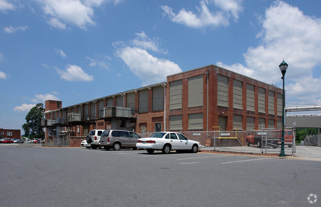
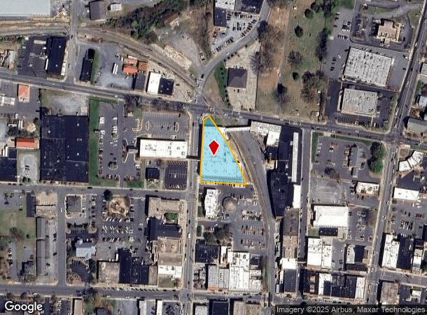
170 N Church St
Greensboro-High Point, NC
CHURCH STREET LOFT APT LLC LO:1 PL:171-82
7751-73-6404
Randolph
Apartment
North Carolina
2025
1
2025
0.85 AC
030100
Asheboro CBD
59,830 SF
Greensboro/Winston-Salem
DEMOGRAPHICS near 170 N Church St
1 Mile
3 Mile
5 Mile
2024 Total Population
9,101
26,173
42,510
2029 Population
9,503
27,221
44,237
Pop Growth 2024-2029
+ 4.42%
+ 4.00%
+ 4.06%
Average Age
39
40
40
2024 Total Households
3,829
10,510
16,899
HH Growth 2024-2029
+ 4.49%
+ 4.02%
+ 4.05%
Median Household Inc
$37,916
$46,080
$48,736
Avg Household Size
2.30
2.40
2.40
2024 Avg HH Vehicles
1.00
2.00
2.00
Median Home Value
$128,757
$146,698
$144,475
Median Year Built
1969
1973
1978
Nearby Places
Map Layers
Map Styles
 Street
 Aerial
- Restaurants
- Banks
- Shops
- Fitness
- Groceries
PUBLIC TRANSPORTATION
AIRPORT
Piedmont Triad International
DRIVE
WALK
Distance
Piedmont Triad International
44 min
33.0 mi
Freight Ports
Port of Wilmington
DRIVE
WALK
Distance
Port of Wilmington
225 min
190.0 mi
Nearby Properties
Address
Land Use
TOTAL SIZE
Lot Size
Zoning
Address
Land Use
TOTAL SIZE
Lot Size
Zoning
312,205 SF
6.83 AC
B2
Address
Land Use
TOTAL SIZE
Lot Size
Zoning
54,565 SF
65.17 AC
B2
Address
Land Use
TOTAL SIZE
Lot Size
Zoning
3,196 SF
24.89 AC
RA6 (CZ)
Address
Land Use
TOTAL SIZE
Lot Size
Zoning
221,524 SF
22.11 AC
B2 (CZ)
Address
Land Use
TOTAL SIZE
Lot Size
Zoning
178,413 SF
36.13 AC
B2
Address
Land Use
TOTAL SIZE
Lot Size
Zoning
178,413 SF
35.87 AC
B2
Address
Land Use
TOTAL SIZE
Lot Size
Zoning
24.92 AC
B2
Address
Land Use
TOTAL SIZE
Lot Size
Zoning
5.24 AC
B3
Address
Land Use
TOTAL SIZE
Lot Size
Zoning
44,912 SF
25.15 AC
I1
Address
Land Use
TOTAL SIZE
Lot Size
Zoning
75,251 SF
18.75 AC
B2 (CZ)
Address
Land Use
TOTAL SIZE
Lot Size
Zoning
26.07 AC
B2
Address
Land Use
TOTAL SIZE
Lot Size
Zoning
84,857 SF
8.31 AC
B2
Address
Land Use
TOTAL SIZE
Lot Size
Zoning
84,329 SF
71.50 AC
I2
Address
Land Use
TOTAL SIZE
Lot Size
Zoning
29,212 SF
104.58 AC
B2
Address
Land Use
TOTAL SIZE
Lot Size
Zoning
84,298 SF
8.25 AC
B2
Address
Land Use
TOTAL SIZE
Lot Size
Zoning
94,956 SF
15.15 AC
B2
Address
Land Use
TOTAL SIZE
Lot Size
Zoning
159,217 SF
25.99 AC
I1
Address
Land Use
TOTAL SIZE
Lot Size
Zoning
52,741 SF
2.53 AC
B2
Address
Land Use
TOTAL SIZE
Lot Size
Zoning
83,900 SF
8.22 AC
B2
Address
Land Use
TOTAL SIZE
Lot Size
Zoning
52,741 SF
2.15 AC
B2
Address
Land Use
TOTAL SIZE
Lot Size
Zoning
136,877 SF
25.59 AC
I1
Address
Land Use
TOTAL SIZE
Lot Size
Zoning
193,214 SF
17.06 AC
I1
Address
Land Use
TOTAL SIZE
Lot Size
Zoning
38,113 SF
8.56 AC
B2
Address
Land Use
TOTAL SIZE
Lot Size
Zoning
38,113 SF
8.16 AC
B2
Address
Land Use
TOTAL SIZE
Lot Size
Zoning
53,871 SF
11.36 AC
B2
Address
Land Use
TOTAL SIZE
Lot Size
Zoning
35,502 SF
2.83 AC
B2
Address
Land Use
TOTAL SIZE
Lot Size
Zoning
2,800 SF
6.64 AC
RA6
Address
Land Use
TOTAL SIZE
Lot Size
Zoning
4,590 SF
15.50 AC
RA6
Address
Land Use
TOTAL SIZE
Lot Size
Zoning
18,144 SF
2.91 AC
B2
Address
Land Use
TOTAL SIZE
Lot Size
Zoning
47,797 SF
2.61 AC
B2 (CZ)
The World's #1 Commercial Real Estate Marketplace
Connect with us
© 2026 CoStar Group
The information above has been obtained from sources believed reliable. While we do not doubt its accuracy we have not verified it and make no guarantee, warranty or representation about it. It is your responsibility to independently confirm its accuracy and completeness. Any projections, opinions, assumptions, or estimates used are for example only and do not represent the current or future performance of the property. The value of this transaction to you depends on tax and other factors which should be evaluated by your tax, financial, and legal advisors. You and your advisors should conduct a careful, independent investigation of the property to determine to your satisfaction the suitability of the property for your needs.