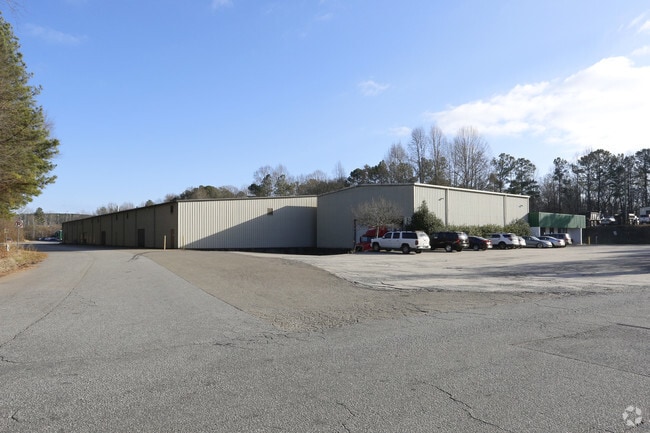
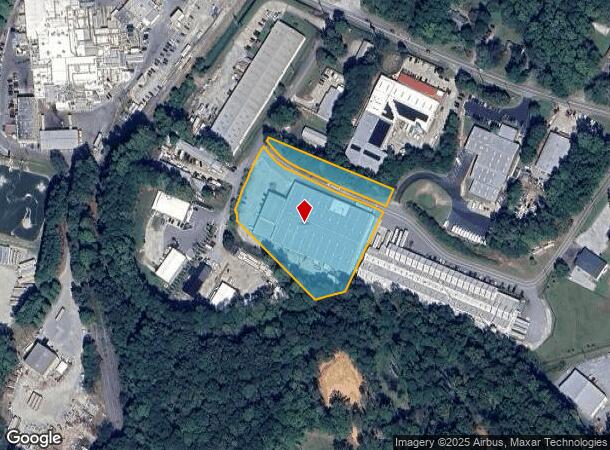
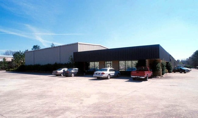
Property Record
170 N Industrial Way, Canton, GA 30115
NEARBY LISTINGS FOR SALE OR LEASE
Property Detail
170 N Industrial Way
015N13-00000-086-00A-0000
LL 127 15TH D
Industrialgeneral
Cherokee
X
Georgia
13057C0253E
127
2025
3.63 AC
2025
Woodstock/Canton
090703
Atlanta
63,752 SF
Atlanta-Sandy Springs-Roswell, GA
DEMOGRAPHICS near 170 N Industrial Way
1 Mile
3 Mile
5 Mile
2024 Total Population
5,531
50,655
102,251
2029 Population
6,380
57,862
117,092
Pop Growth 2024-2029
+ 15.35%
+ 14.23%
+ 14.51%
Average Age
37
37
39
2024 Total Households
2,108
17,303
35,955
HH Growth 2024-2029
+ 15.51%
+ 14.42%
+ 14.68%
Median Household Inc
$80,686
$95,317
$95,570
Avg Household Size
2.50
2.80
2.80
2024 Avg HH Vehicles
2.00
2.00
2.00
Median Home Value
$267,689
$327,920
$361,682
Median Year Built
2003
2002
2002
Nearby Places
- Restaurants
- Banks
- Shops
- Fitness
- Groceries
Nearby Properties
Address
Land Use
TOTAL SIZE
Lot Size
Zoning
Address
Land Use
TOTAL SIZE
Lot Size
Zoning
275,118 SF
21.61 AC
R-40
Address
Land Use
TOTAL SIZE
Lot Size
Zoning
255,483 SF
138.30 AC
LI
Address
Land Use
TOTAL SIZE
Lot Size
Zoning
443,973 SF
70.02 AC
GC
Address
Land Use
TOTAL SIZE
Lot Size
Zoning
353,395 SF
29.15 AC
GC
Address
Land Use
TOTAL SIZE
Lot Size
Zoning
162,243 SF
29.44 AC
R-5
Address
Land Use
TOTAL SIZE
Lot Size
Zoning
79,162 SF
8.54 AC
RM16
Address
Land Use
TOTAL SIZE
Lot Size
Zoning
103,620 SF
19.78 AC
R-5
Address
Land Use
TOTAL SIZE
Lot Size
Zoning
302,757 SF
62.80 AC
PUD
Address
Land Use
TOTAL SIZE
Lot Size
Zoning
177,744 SF
23.73 AC
PUD
Address
Land Use
TOTAL SIZE
Lot Size
Zoning
155,341 SF
14.54 AC
R-5
Address
Land Use
TOTAL SIZE
Lot Size
Zoning
241,482 SF
31.65 AC
PD
Address
Land Use
TOTAL SIZE
Lot Size
Zoning
43,897 SF
8.45 AC
PUD
Address
Land Use
TOTAL SIZE
Lot Size
Zoning
149,713 SF
36.97 AC
R-80
Address
Land Use
TOTAL SIZE
Lot Size
Zoning
138,048 SF
21.40 AC
R-40
Address
Land Use
TOTAL SIZE
Lot Size
Zoning
182,067 SF
23.83 AC
GC
Address
Land Use
TOTAL SIZE
Lot Size
Zoning
134,017 SF
42.78 AC
AG
Address
Land Use
TOTAL SIZE
Lot Size
Zoning
85,408 SF
37.56 AC
AG
Address
Land Use
TOTAL SIZE
Lot Size
Zoning
81,237 SF
11.63 AC
R-5
Address
Land Use
TOTAL SIZE
Lot Size
Zoning
70,397 SF
13.24 AC
R-20
Address
Land Use
TOTAL SIZE
Lot Size
Zoning
35,443 SF
OI
Address
Land Use
TOTAL SIZE
Lot Size
Zoning
44,397 SF
15.84 AC
GC
Address
Land Use
TOTAL SIZE
Lot Size
Zoning
69,360 SF
5.86 AC
R-80
Address
Land Use
TOTAL SIZE
Lot Size
Zoning
57,363 SF
19.68 AC
PUD
Address
Land Use
TOTAL SIZE
Lot Size
Zoning
35,360 SF
OI
Address
Land Use
TOTAL SIZE
Lot Size
Zoning
78,503 SF
9.51 AC
PUD
Address
Land Use
TOTAL SIZE
Lot Size
Zoning
158,853 SF
33.73 AC
LI
Address
Land Use
TOTAL SIZE
Lot Size
Zoning
31,232 SF
8.61 AC
LI
Address
Land Use
TOTAL SIZE
Lot Size
Zoning
110,264 SF
8.83 AC
LI
Address
Land Use
TOTAL SIZE
Lot Size
Zoning
67,422 SF
8.14 AC
PUD
Address
Land Use
TOTAL SIZE
Lot Size
Zoning
56,484 SF
9.04 AC
GC
The World's #1 Commercial Real Estate Marketplace
Connect with us
© 2025 CoStar Group
The information above has been obtained from sources believed reliable. While we do not doubt its accuracy we have not verified it and make no guarantee, warranty or representation about it. It is your responsibility to independently confirm its accuracy and completeness. Any projections, opinions, assumptions, or estimates used are for example only and do not represent the current or future performance of the property. The value of this transaction to you depends on tax and other factors which should be evaluated by your tax, financial, and legal advisors. You and your advisors should conduct a careful, independent investigation of the property to determine to your satisfaction the suitability of the property for your needs.