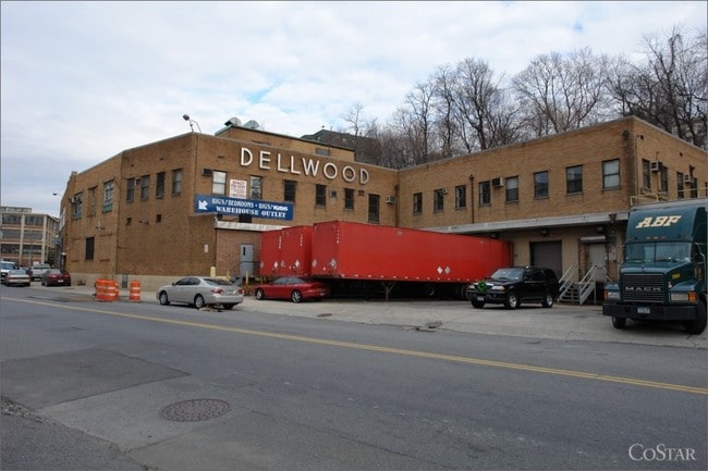
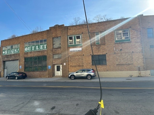
Property Record
170 Saw Mill River Rd, Elmsford, NY 10523
Current Lease Availabilities
NEARBY LISTINGS FOR SALE OR LEASE
Property Detail
170 Saw Mill River Rd
New York-Jersey City-White Plains, NY-NJ
Building Lots And Villa Sites At Elmsfor
2689-007-190-00079-000-0022
Westchester
Commercialacreage
New York
X
43.000
36119C0262F
0.18 AC
2025
Southwest
2024
Westchester/So Connecticut
001600
DEMOGRAPHICS near 170 Saw Mill River Rd
1 Mile
3 Mile
5 Mile
2024 Total Population
48,438
233,473
636,691
2029 Population
47,053
227,386
608,527
Pop Growth 2024-2029
(2.86%)
(2.61%)
(4.42%)
Average Age
39
41
41
2024 Total Households
17,493
89,242
237,113
HH Growth 2024-2029
(3.08%)
(2.74%)
(4.71%)
Median Household Inc
$55,882
$75,614
$76,707
Avg Household Size
2.60
2.50
2.60
2024 Avg HH Vehicles
1.00
1.00
1.00
Median Home Value
$412,822
$470,556
$584,740
Median Year Built
1954
1955
1953
Nearby Places
- Restaurants
- Banks
- Shops
- Fitness
- Groceries
PUBLIC TRANSPORTATION
COMMUTER RAIL
White Plains Station (Harlem Line - Metro-North Commuter Railroad Company (Metro-North))
DRIVE
WALK
Distance
White Plains Station (Harlem Line - Metro-North Commuter Railroad Company (Metro-North))
7 min
3.5 mi
Valhalla Station (Harlem Line - Metro-North Commuter Railroad Company (Metro-North))
DRIVE
WALK
Distance
Valhalla Station (Harlem Line - Metro-North Commuter Railroad Company (Metro-North))
8 min
4.2 mi
AIRPORT
Westchester County
DRIVE
WALK
Distance
Westchester County
17 min
11.3 mi
LaGuardia
DRIVE
WALK
Distance
LaGuardia
40 min
25.5 mi
John F Kennedy International
DRIVE
WALK
Distance
John F Kennedy International
52 min
34.3 mi
Freight Ports
NY - Red Hook Container Terminal
DRIVE
WALK
Distance
NY - Red Hook Container Terminal
54 min
33.7 mi
Nearby Properties
Address
Land Use
TOTAL SIZE
Lot Size
Zoning
Address
Land Use
TOTAL SIZE
Lot Size
Zoning
358.83 AC
Address
Land Use
TOTAL SIZE
Lot Size
Zoning
85.40 AC
Address
Land Use
TOTAL SIZE
Lot Size
Zoning
4.45 AC
B
Address
Land Use
TOTAL SIZE
Lot Size
Zoning
2,760 SF
60.76 AC
Address
Land Use
TOTAL SIZE
Lot Size
Zoning
63.40 AC
R-40
Address
Land Use
TOTAL SIZE
Lot Size
Zoning
63.48 AC
R-30
Address
Land Use
TOTAL SIZE
Lot Size
Zoning
22.92 AC
Address
Land Use
TOTAL SIZE
Lot Size
Zoning
75.87 AC
R-20
Address
Land Use
TOTAL SIZE
Lot Size
Zoning
Address
Land Use
TOTAL SIZE
Lot Size
Zoning
24.28 AC
Address
Land Use
TOTAL SIZE
Lot Size
Zoning
17.61 AC
Address
Land Use
TOTAL SIZE
Lot Size
Zoning
36.59 AC
Address
Land Use
TOTAL SIZE
Lot Size
Zoning
17.17 AC
Address
Land Use
TOTAL SIZE
Lot Size
Zoning
14.86 AC
OB
Address
Land Use
TOTAL SIZE
Lot Size
Zoning
24.66 AC
Address
Land Use
TOTAL SIZE
Lot Size
Zoning
16.22 AC
UR
Address
Land Use
TOTAL SIZE
Lot Size
Zoning
29.35 AC
Address
Land Use
TOTAL SIZE
Lot Size
Zoning
7.78 AC
Address
Land Use
TOTAL SIZE
Lot Size
Zoning
19.25 AC
Address
Land Use
TOTAL SIZE
Lot Size
Zoning
28.51 AC
Address
Land Use
TOTAL SIZE
Lot Size
Zoning
37.99 AC
Address
Land Use
TOTAL SIZE
Lot Size
Zoning
253,167 SF
9.11 AC
OB
Address
Land Use
TOTAL SIZE
Lot Size
Zoning
60.01 AC
Address
Land Use
TOTAL SIZE
Lot Size
Zoning
8.42 AC
Address
Land Use
TOTAL SIZE
Lot Size
Zoning
22.44 AC
R-20
Address
Land Use
TOTAL SIZE
Lot Size
Zoning
26.50 AC
Address
Land Use
TOTAL SIZE
Lot Size
Zoning
205,000 SF
7.85 AC
Address
Land Use
TOTAL SIZE
Lot Size
Zoning
9.67 AC
Address
Land Use
TOTAL SIZE
Lot Size
Zoning
11.61 AC
Address
Land Use
TOTAL SIZE
Lot Size
Zoning
The World's #1 Commercial Real Estate Marketplace
Connect with us
© 2025 CoStar Group
The information above has been obtained from sources believed reliable. While we do not doubt its accuracy we have not verified it and make no guarantee, warranty or representation about it. It is your responsibility to independently confirm its accuracy and completeness. Any projections, opinions, assumptions, or estimates used are for example only and do not represent the current or future performance of the property. The value of this transaction to you depends on tax and other factors which should be evaluated by your tax, financial, and legal advisors. You and your advisors should conduct a careful, independent investigation of the property to determine to your satisfaction the suitability of the property for your needs.