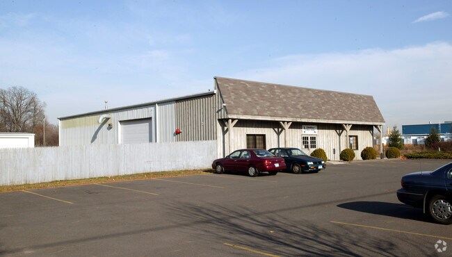
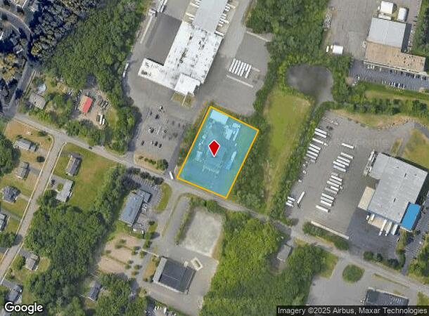
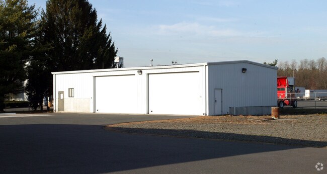
Property Record
170 Strong Rd, South Windsor, CT 06074
NEARBY LISTINGS FOR SALE OR LEASE
Property Detail
170 Strong Rd
SWIN-000096-000000-000062
Hartford
Commercialnec
Connecticut
X
1.71 AC
09003C0376F
South Windsor
2024
Hartford
2025
Hartford-West Hartford-East Hartford, CT
487300
DEMOGRAPHICS near 170 Strong Rd
1 mile
3 mile
5 mile
2024 Total Population
636
21,971
88,752
2029 Population
639
21,771
88,362
Pop Growth 2024-2029
+ 0.47%
(0.91%)
(0.44%)
Average Age
45
42
41
2024 Total Households
260
8,770
35,141
HH Growth 2024-2029
+ 0.38%
(1.05%)
(0.49%)
Median Household Inc
$133,482
$108,448
$87,520
Avg Household Size
2.40
2.40
2.50
2024 Avg HH Vehicles
2.00
2.00
2.00
Median Home Value
$350,000
$261,529
$246,914
Median Year Built
1956
1966
1970
Nearby Places
Map Layers
Map Styles
 Street
 Aerial
Transit
 Traffic
 Biking
Places
Listings with unknown addresses are not visible on the map
- Restaurants
- Banks
- Shops
- Fitness
- Groceries
PUBLIC TRANSPORTATION
COMMUTER RAIL
Drive
Walk
Distance
14 min
7.7 mi
Windsor Locks (Hartford Line - CT Rail (CTRail))
Drive
Walk
Distance
Windsor Locks (Hartford Line - CT Rail (CTRail))
14 min
7.8 mi
AIRPORT
Bradley International
Drive
Walk
Distance
Bradley International
24 min
10.4 mi
Freight Ports
Port of New Haven
Drive
Walk
Distance
Port of New Haven
63 min
45.6 mi
Nearby Properties
Address
Land Use
TOTAL SIZE
Lot Size
Zoning
Address
Land Use
TOTAL SIZE
Lot Size
Zoning
13,680 SF
240.83 AC
Address
Land Use
TOTAL SIZE
Lot Size
Zoning
248,364 SF
47.28 AC
A20
Address
Land Use
TOTAL SIZE
Lot Size
Zoning
659,693 SF
102.30 AC
I
Address
Land Use
TOTAL SIZE
Lot Size
Zoning
301,011 SF
60.83 AC
I
Address
Land Use
TOTAL SIZE
Lot Size
Zoning
6.50 AC
Address
Land Use
TOTAL SIZE
Lot Size
Zoning
421,152 SF
45.95 AC
CD
Address
Land Use
TOTAL SIZE
Lot Size
Zoning
35.05 AC
FP
Address
Land Use
TOTAL SIZE
Lot Size
Zoning
177,630 SF
32.64 AC
Address
Land Use
TOTAL SIZE
Lot Size
Zoning
247,428 SF
35.46 AC
Address
Land Use
TOTAL SIZE
Lot Size
Zoning
101,317 SF
24.91 AC
RR
Address
Land Use
TOTAL SIZE
Lot Size
Zoning
209,744 SF
25.67 AC
CD
Address
Land Use
TOTAL SIZE
Lot Size
Zoning
259,600 SF
25.58 AC
CD
Address
Land Use
TOTAL SIZE
Lot Size
Zoning
302,370 SF
16.43 AC
I
Address
Land Use
TOTAL SIZE
Lot Size
Zoning
182,628 SF
15.94 AC
CD
Address
Land Use
TOTAL SIZE
Lot Size
Zoning
416,640 SF
30 AC
I
Address
Land Use
TOTAL SIZE
Lot Size
Zoning
768 SF
15.72 AC
Address
Land Use
TOTAL SIZE
Lot Size
Zoning
62,487 SF
14.35 AC
CD
Address
Land Use
TOTAL SIZE
Lot Size
Zoning
153,247 SF
19.85 AC
I
Address
Land Use
TOTAL SIZE
Lot Size
Zoning
11,212 SF
15.54 AC
Address
Land Use
TOTAL SIZE
Lot Size
Zoning
168,000 SF
13.86 AC
I
Address
Land Use
TOTAL SIZE
Lot Size
Zoning
59,882 SF
6 AC
RC
Address
Land Use
TOTAL SIZE
Lot Size
Zoning
229,636 SF
15.05 AC
I
Address
Land Use
TOTAL SIZE
Lot Size
Zoning
76,907 SF
6.97 AC
RC
Address
Land Use
TOTAL SIZE
Lot Size
Zoning
13.39 AC
RR
Address
Land Use
TOTAL SIZE
Lot Size
Zoning
44,363 SF
23 AC
A20
Address
Land Use
TOTAL SIZE
Lot Size
Zoning
43.62 AC
Address
Land Use
TOTAL SIZE
Lot Size
Zoning
242,072 SF
12.07 AC
I
Address
Land Use
TOTAL SIZE
Lot Size
Zoning
49,088 SF
1.47 AC
Address
Land Use
TOTAL SIZE
Lot Size
Zoning
120,328 SF
10.41 AC
I
Address
Land Use
TOTAL SIZE
Lot Size
Zoning
The World's #1 Commercial Real Estate Marketplace
Connect with us
© 2026 CoStar Group
The information above has been obtained from sources believed reliable. While we do not doubt its accuracy we have not verified it and make no guarantee, warranty or representation about it. It is your responsibility to independently confirm its accuracy and completeness. Any projections, opinions, assumptions, or estimates used are for example only and do not represent the current or future performance of the property. The value of this transaction to you depends on tax and other factors which should be evaluated by your tax, financial, and legal advisors. You and your advisors should conduct a careful, independent investigation of the property to determine to your satisfaction the suitability of the property for your needs.