Property Record
170 Thompson Rd, Webster, MA 01570
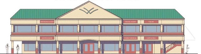

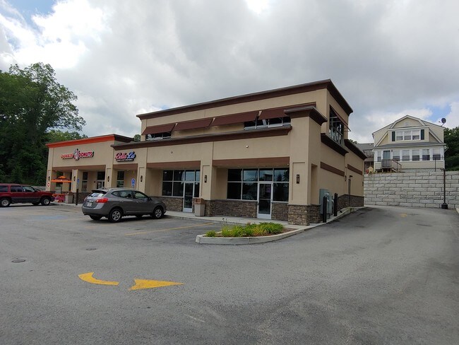
Property Detail
170 Thompson Rd
Commercialofficeresidentialmixeduse
WORCESTER
GB-4 W
Massachusetts
B and X Area of moderate flood hazard, usually the area between the limits of the 100-year and 500-year floods.
0.98 AC
2025
Outlying Worcester
2025
Boston
754200
Worcester, MA
2,064 SF
WEBS-000030-D000000-000002
NEARBY LISTINGS FOR SALE OR LEASE
DEMOGRAPHICS near 170 Thompson Rd
1 mile
3 mile
5 mile
2025 Total Population
6,279
26,239
41,710
2030 Population
6,352
26,755
42,641
Pop Growth 2025-2030
+ 1.16%
+ 1.97%
+ 2.23%
Average Age
43
43
43
2025 Total Households
2,841
11,147
16,906
HH Growth 2025-2030
+ 1.27%
+ 2.05%
+ 2.30%
Median Household Inc
$70,842
$74,005
$84,683
Avg Household Size
2.20
2.30
2.40
2025 Avg HH Vehicles
2.00
2.00
2.00
Median Home Value
$366,505
$374,101
$372,657
Median Year Built
1954
1963
1967
Nearby Places
Map Layers
Map Styles
 Street
 Aerial
Layers
 Traffic
 Biking
Places
Listings with unknown addresses are not visible on the map
- Restaurants
- Banks
- Shops
- Fitness
- Groceries
PUBLIC TRANSPORTATION
AIRPORT
Worcester Regional
Drive
Walk
Distance
Worcester Regional
32 min
19.1 mi
Rhode Island Tf Green International
Drive
Walk
Distance
Rhode Island Tf Green International
64 min
49.7 mi
Freight Ports
Port of Boston
Drive
Walk
Distance
Port of Boston
77 min
58.2 mi
SALE & LEASE HISTORY
LISTING DATE
SALE/LEASE

Aug 23, 2019
For Lease
Nearby Properties
Address
Land Use
TOTAL SIZE
Lot Size
Zoning
Address
Land Use
TOTAL SIZE
Lot Size
Zoning
60.14 AC
Address
Land Use
TOTAL SIZE
Lot Size
Zoning
95,274 SF
10.18 AC
Address
Land Use
TOTAL SIZE
Lot Size
Zoning
187,396 SF
90.39 AC
Address
Land Use
TOTAL SIZE
Lot Size
Zoning
34 AC
LI
Address
Land Use
TOTAL SIZE
Lot Size
Zoning
9.05 AC
INDUST
Address
Land Use
TOTAL SIZE
Lot Size
Zoning
131,686 SF
14.60 AC
INDUST
Address
Land Use
TOTAL SIZE
Lot Size
Zoning
13.22 AC
INDUST
Address
Land Use
TOTAL SIZE
Lot Size
Zoning
175,000 SF
10.01 AC
LI
Address
Land Use
TOTAL SIZE
Lot Size
Zoning
4.87 AC
INDUST
Address
Land Use
TOTAL SIZE
Lot Size
Zoning
20.31 AC
INDUST
Address
Land Use
TOTAL SIZE
Lot Size
Zoning
10.09 AC
Address
Land Use
TOTAL SIZE
Lot Size
Zoning
101,227 SF
8.48 AC
Address
Land Use
TOTAL SIZE
Lot Size
Zoning
2.15 AC
GB-4 W
Address
Land Use
TOTAL SIZE
Lot Size
Zoning
102,704 SF
31 AC
GB-4 W
Address
Land Use
TOTAL SIZE
Lot Size
Zoning
164,660 SF
15.40 AC
INDUST
Address
Land Use
TOTAL SIZE
Lot Size
Zoning
Address
Land Use
TOTAL SIZE
Lot Size
Zoning
123,910 SF
10 AC
INDUST
Address
Land Use
TOTAL SIZE
Lot Size
Zoning
60 AC
INDUST
Address
Land Use
TOTAL SIZE
Lot Size
Zoning
52,677 SF
15.17 AC
Address
Land Use
TOTAL SIZE
Lot Size
Zoning
8.96 AC
GB-5 W
Address
Land Use
TOTAL SIZE
Lot Size
Zoning
54,273 SF
8.94 AC
INDUST
Address
Land Use
TOTAL SIZE
Lot Size
Zoning
3.60 AC
Address
Land Use
TOTAL SIZE
Lot Size
Zoning
21,111 SF
1.71 AC
GB-4 W
Address
Land Use
TOTAL SIZE
Lot Size
Zoning
37,907 SF
28.50 AC
Address
Land Use
TOTAL SIZE
Lot Size
Zoning
18.60 AC
GB-5 W
Address
Land Use
TOTAL SIZE
Lot Size
Zoning
5.24 AC
GB-4 W
Address
Land Use
TOTAL SIZE
Lot Size
Zoning
33,063 SF
1.96 AC
Address
Land Use
TOTAL SIZE
Lot Size
Zoning
6.08 AC
MR-12,
Address
Land Use
TOTAL SIZE
Lot Size
Zoning
4.60 AC
I
Address
Land Use
TOTAL SIZE
Lot Size
Zoning
10 AC
LI
The World's #1 Commercial Real Estate Marketplace
Connect with us
© 2026 CoStar Group
The information above has been obtained from sources believed reliable. While we do not doubt its accuracy we have not verified it and make no guarantee, warranty or representation about it. It is your responsibility to independently confirm its accuracy and completeness. Any projections, opinions, assumptions, or estimates used are for example only and do not represent the current or future performance of the property. The value of this transaction to you depends on tax and other factors which should be evaluated by your tax, financial, and legal advisors. You and your advisors should conduct a careful, independent investigation of the property to determine to your satisfaction the suitability of the property for your needs.