Property Record
170 Travis Way, Manhattan, MT 59741

NEARBY LISTINGS FOR SALE OR LEASE
-
-
View all Manhattan listings for sale on LoopNet.com
Property Detail
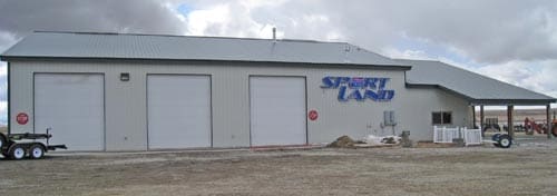
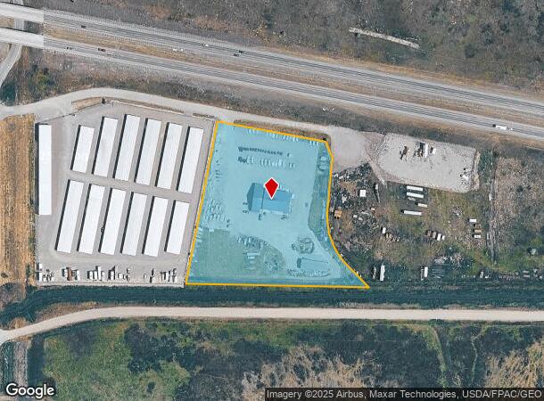
170 Travis Way
06-1009-11-3-02-01-0000
Minor Sub 399
Vehiclerentalsvehiclesales
MINOR SUB 399, S11, T01 N, R03 E, LOT 2, ACRES 4.473
X
Gallatin
30031C0555E
Montana
2025
2
2025
4.47 AC
000400
Other Market Areas
6,000 SF
Bozeman, MT
DEMOGRAPHICS near 170 Travis Way
1 Mile
3 Mile
5 Mile
2024 Total Population
1,439
2,555
3,488
2029 Population
1,602
2,841
3,874
Pop Growth 2024-2029
+ 11.33%
+ 11.19%
+ 11.07%
Average Age
40
40
41
2024 Total Households
574
1,003
1,337
HH Growth 2024-2029
+ 11.67%
+ 11.57%
+ 11.44%
Median Household Inc
$60,346
$68,624
$72,439
Avg Household Size
2.50
2.50
2.60
2024 Avg HH Vehicles
2.00
2.00
2.00
Median Home Value
$391,757
$488,461
$555,093
Median Year Built
1969
1976
1984
Nearby Places
Map Layers
Map Styles
 Street
 Aerial
- Restaurants
- Banks
- Shops
- Fitness
- Groceries
PUBLIC TRANSPORTATION
AIRPORT
Bozeman Yellowstone International
DRIVE
WALK
Distance
Bozeman Yellowstone International
19 min
11.2 mi
Nearby Properties
Address
Land Use
TOTAL SIZE
Lot Size
Zoning
Address
Land Use
TOTAL SIZE
Lot Size
Zoning
38,557 SF
3.10 AC
R3
Address
Land Use
TOTAL SIZE
Lot Size
Zoning
11,635 SF
2.40 AC
B2
Address
Land Use
TOTAL SIZE
Lot Size
Zoning
79,044 SF
5.96 AC
M1
Address
Land Use
TOTAL SIZE
Lot Size
Zoning
8,000 SF
6.19 AC
Address
Land Use
TOTAL SIZE
Lot Size
Zoning
54,898 SF
3.82 AC
M1
Address
Land Use
TOTAL SIZE
Lot Size
Zoning
1,523 SF
36.58 AC
6
Address
Land Use
TOTAL SIZE
Lot Size
Zoning
1,440 SF
5.01 AC
Address
Land Use
TOTAL SIZE
Lot Size
Zoning
21,400 SF
2.03 AC
M1
Address
Land Use
TOTAL SIZE
Lot Size
Zoning
17,593 SF
1.71 AC
M1
Address
Land Use
TOTAL SIZE
Lot Size
Zoning
10,526 SF
0.48 AC
1
Address
Land Use
TOTAL SIZE
Lot Size
Zoning
4,968 SF
3.04 AC
R3
Address
Land Use
TOTAL SIZE
Lot Size
Zoning
10,633 SF
1.14 AC
R3
Address
Land Use
TOTAL SIZE
Lot Size
Zoning
22,040 SF
1.76 AC
M1
Address
Land Use
TOTAL SIZE
Lot Size
Zoning
7,749 SF
1.12 AC
R3
Address
Land Use
TOTAL SIZE
Lot Size
Zoning
10,633 SF
0.74 AC
R3
Address
Land Use
TOTAL SIZE
Lot Size
Zoning
30,084 SF
0.78 AC
Address
Land Use
TOTAL SIZE
Lot Size
Zoning
6,001 SF
0.90 AC
Address
Land Use
TOTAL SIZE
Lot Size
Zoning
36.36 AC
Address
Land Use
TOTAL SIZE
Lot Size
Zoning
9,605 SF
2.11 AC
M1
Address
Land Use
TOTAL SIZE
Lot Size
Zoning
1,556 SF
4.51 AC
Address
Land Use
TOTAL SIZE
Lot Size
Zoning
7,749 SF
0.70 AC
M1
Address
Land Use
TOTAL SIZE
Lot Size
Zoning
6,000 SF
0.14 AC
6
Address
Land Use
TOTAL SIZE
Lot Size
Zoning
3,819 SF
0.88 AC
6
Address
Land Use
TOTAL SIZE
Lot Size
Zoning
6,200 SF
0.15 AC
6
Address
Land Use
TOTAL SIZE
Lot Size
Zoning
12.83 AC
1
Address
Land Use
TOTAL SIZE
Lot Size
Zoning
2,860 SF
0.44 AC
1
Address
Land Use
TOTAL SIZE
Lot Size
Zoning
4,616 SF
0.48 AC
6
Address
Land Use
TOTAL SIZE
Lot Size
Zoning
6,681 SF
1.46 AC
M1
The World's #1 Commercial Real Estate Marketplace
Connect with us
© 2025 CoStar Group
The information above has been obtained from sources believed reliable. While we do not doubt its accuracy we have not verified it and make no guarantee, warranty or representation about it. It is your responsibility to independently confirm its accuracy and completeness. Any projections, opinions, assumptions, or estimates used are for example only and do not represent the current or future performance of the property. The value of this transaction to you depends on tax and other factors which should be evaluated by your tax, financial, and legal advisors. You and your advisors should conduct a careful, independent investigation of the property to determine to your satisfaction the suitability of the property for your needs.