Property Record
170 Vergason Ave, Norwich, CT 06360
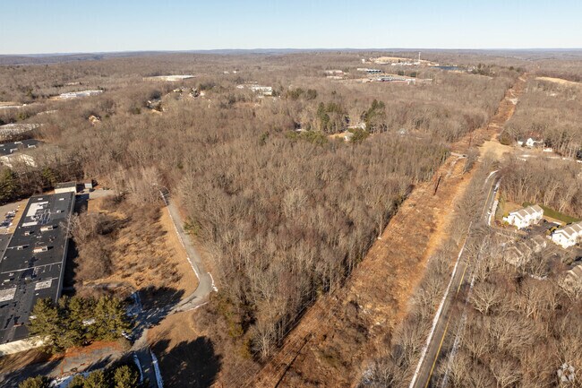
Property Detail
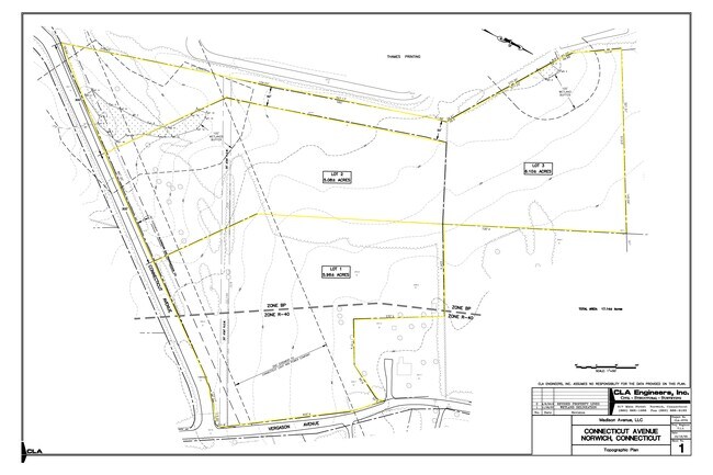
170 Vergason Ave
42 1 19 1
NEW LONDON
Residentialacreage
Connecticut
R40
19
B and X Area of moderate flood hazard, usually the area between the limits of the 100-year and 500-year floods.
5.77 AC
2025
NE New London/Norwich
2025
Hartford
696200
Norwich-New London-Willimantic, CT
NEARBY LISTINGS FOR SALE OR LEASE
DEMOGRAPHICS near 170 Vergason Ave
1 mile
3 mile
5 mile
2025 Total Population
1,869
13,135
48,215
2030 Population
1,907
13,241
48,649
Pop Growth 2025-2030
+ 2.03%
+ 0.81%
+ 0.90%
Average Age
43
43
41
2025 Total Households
854
5,555
20,074
HH Growth 2025-2030
+ 1.87%
+ 0.77%
+ 0.88%
Median Household Inc
$89,211
$78,774
$69,567
Avg Household Size
2.20
2.30
2.30
2025 Avg HH Vehicles
2.00
2.00
2.00
Median Home Value
$334,036
$277,862
$258,840
Median Year Built
1982
1958
1957
Nearby Places
Map Layers
Map Styles
 Street
 Aerial
Layers
 Traffic
 Biking
Places
Listings with unknown addresses are not visible on the map
- Restaurants
- Banks
- Shops
- Fitness
- Groceries
SALE & LEASE HISTORY
LISTING DATE
SALE/LEASE

Feb 25, 2022
For Lease
Nearby Properties
Address
Land Use
TOTAL SIZE
Lot Size
Zoning
Address
Land Use
TOTAL SIZE
Lot Size
Zoning
200,847 SF
14.30 AC
R40
Address
Land Use
TOTAL SIZE
Lot Size
Zoning
13.78 AC
R40
Address
Land Use
TOTAL SIZE
Lot Size
Zoning
179,652 SF
16.82 AC
PC
Address
Land Use
TOTAL SIZE
Lot Size
Zoning
128,565 SF
18.90 AC
R40
Address
Land Use
TOTAL SIZE
Lot Size
Zoning
4.18 AC
R20
Address
Land Use
TOTAL SIZE
Lot Size
Zoning
2,544 SF
184.20 AC
R-2
Address
Land Use
TOTAL SIZE
Lot Size
Zoning
41,621 SF
47.24 AC
BP/R40
Address
Land Use
TOTAL SIZE
Lot Size
Zoning
87,162 SF
30.20 AC
R20/MF
Address
Land Use
TOTAL SIZE
Lot Size
Zoning
11,510 SF
19.23 AC
BP/R40
Address
Land Use
TOTAL SIZE
Lot Size
Zoning
3.76 AC
MF
Address
Land Use
TOTAL SIZE
Lot Size
Zoning
351.80 AC
ROS
Address
Land Use
TOTAL SIZE
Lot Size
Zoning
70,639 SF
14 AC
R-80
Address
Land Use
TOTAL SIZE
Lot Size
Zoning
136,074 SF
8.51 AC
BP
Address
Land Use
TOTAL SIZE
Lot Size
Zoning
7.78 AC
BP
Address
Land Use
TOTAL SIZE
Lot Size
Zoning
3.85 AC
GC
Address
Land Use
TOTAL SIZE
Lot Size
Zoning
162,122 SF
8.48 AC
BP
Address
Land Use
TOTAL SIZE
Lot Size
Zoning
83,453 SF
5.80 AC
MF
Address
Land Use
TOTAL SIZE
Lot Size
Zoning
44,294 SF
5.18 AC
BP
Address
Land Use
TOTAL SIZE
Lot Size
Zoning
219,698 SF
14 AC
BP
Address
Land Use
TOTAL SIZE
Lot Size
Zoning
61,418 SF
6.37 AC
R-2
Address
Land Use
TOTAL SIZE
Lot Size
Zoning
3.28 AC
R20
Address
Land Use
TOTAL SIZE
Lot Size
Zoning
37,360 SF
2 AC
R20
Address
Land Use
TOTAL SIZE
Lot Size
Zoning
26.46 AC
BP
Address
Land Use
TOTAL SIZE
Lot Size
Zoning
8.43 AC
R40
Address
Land Use
TOTAL SIZE
Lot Size
Zoning
73,470 SF
13.11 AC
BP
Address
Land Use
TOTAL SIZE
Lot Size
Zoning
50,833 SF
3.61 AC
BP
Address
Land Use
TOTAL SIZE
Lot Size
Zoning
213,280 SF
25.58 AC
BP
Address
Land Use
TOTAL SIZE
Lot Size
Zoning
11.87 AC
C-2
Address
Land Use
TOTAL SIZE
Lot Size
Zoning
17,424 SF
14.07 AC
IND
Address
Land Use
TOTAL SIZE
Lot Size
Zoning
6.65 AC
MF
The World's #1 Commercial Real Estate Marketplace
Connect with us
© 2026 CoStar Group
The information above has been obtained from sources believed reliable. While we do not doubt its accuracy we have not verified it and make no guarantee, warranty or representation about it. It is your responsibility to independently confirm its accuracy and completeness. Any projections, opinions, assumptions, or estimates used are for example only and do not represent the current or future performance of the property. The value of this transaction to you depends on tax and other factors which should be evaluated by your tax, financial, and legal advisors. You and your advisors should conduct a careful, independent investigation of the property to determine to your satisfaction the suitability of the property for your needs.