Property Record
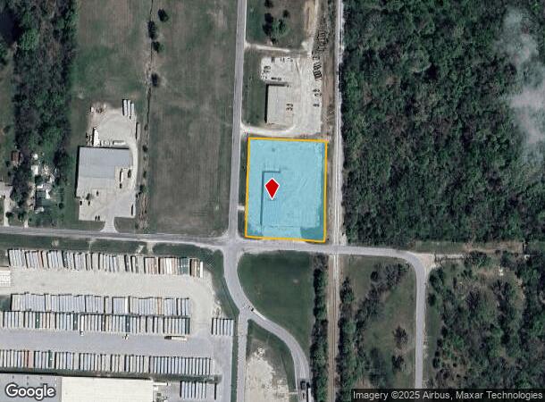
1700 Anaconda Rd, Harrisonville, MO 64701

NEARBY LISTINGS FOR SALE OR LEASE
-
-
View all Harrisonville listings for lease on LoopNet.com
Property Detail
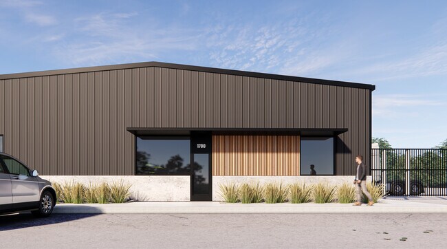
1700 Anaconda Rd
Kansas City, MO-KS
Vine Street Industrial Park
0947200
PT W2 LT 1 NE,S1.71A LYG W OF RR R/W & E OF ANA RD
Storebuilding
Cass
X
Missouri
29037C0188F
1
2023
1.71 AC
2025
Cass County
061400
Kansas City
32,400 SF
DEMOGRAPHICS near 1700 Anaconda Rd
1 Mile
3 Mile
5 Mile
2024 Total Population
2,153
11,082
13,865
2029 Population
2,290
11,735
14,676
Pop Growth 2024-2029
+ 6.36%
+ 5.89%
+ 5.85%
Average Age
37
40
41
2024 Total Households
805
4,288
5,330
HH Growth 2024-2029
+ 6.58%
+ 6.02%
+ 5.98%
Median Household Inc
$59,761
$61,658
$65,535
Avg Household Size
2.40
2.40
2.50
2024 Avg HH Vehicles
2.00
2.00
2.00
Median Home Value
$150,797
$205,909
$232,308
Median Year Built
1968
1975
1977
Nearby Places
Map Layers
Map Styles
 Street
 Aerial
- Restaurants
- Banks
- Shops
- Fitness
- Groceries
SALE & LEASE HISTORY
LISTING DATE
SALE/LEASE

Sep 19, 2022
For Sale
Mar 20, 2025
For Lease
Mar 06, 2023
For Lease
Nearby Properties
Address
Land Use
TOTAL SIZE
Lot Size
Zoning
Address
Land Use
TOTAL SIZE
Lot Size
Zoning
197,883 SF
30 AC
Address
Land Use
TOTAL SIZE
Lot Size
Zoning
367,575 SF
53.34 AC
Address
Land Use
TOTAL SIZE
Lot Size
Zoning
996,962 SF
75.28 AC
Address
Land Use
TOTAL SIZE
Lot Size
Zoning
219,735 SF
33.54 AC
Address
Land Use
TOTAL SIZE
Lot Size
Zoning
1,030,621 SF
43.38 AC
Address
Land Use
TOTAL SIZE
Lot Size
Zoning
411,232 SF
26.77 AC
Address
Land Use
TOTAL SIZE
Lot Size
Zoning
157,628 SF
5.06 AC
Address
Land Use
TOTAL SIZE
Lot Size
Zoning
55,413 SF
8 AC
Address
Land Use
TOTAL SIZE
Lot Size
Zoning
1,126,810 SF
17.17 AC
Address
Land Use
TOTAL SIZE
Lot Size
Zoning
42,378 SF
14.20 AC
Address
Land Use
TOTAL SIZE
Lot Size
Zoning
Address
Land Use
TOTAL SIZE
Lot Size
Zoning
15,840 SF
20 AC
Address
Land Use
TOTAL SIZE
Lot Size
Zoning
105,500 SF
4.29 AC
Address
Land Use
TOTAL SIZE
Lot Size
Zoning
103,920 SF
12.29 AC
Address
Land Use
TOTAL SIZE
Lot Size
Zoning
53,673 SF
12.16 AC
Address
Land Use
TOTAL SIZE
Lot Size
Zoning
65,356 SF
6.21 AC
Address
Land Use
TOTAL SIZE
Lot Size
Zoning
19,600 SF
6.30 AC
Address
Land Use
TOTAL SIZE
Lot Size
Zoning
40,784 SF
0.45 AC
Address
Land Use
TOTAL SIZE
Lot Size
Zoning
460,328 SF
20 AC
Address
Land Use
TOTAL SIZE
Lot Size
Zoning
45,480 SF
6.46 AC
Address
Land Use
TOTAL SIZE
Lot Size
Zoning
62,008 SF
4.97 AC
Address
Land Use
TOTAL SIZE
Lot Size
Zoning
74,086 SF
5.39 AC
Address
Land Use
TOTAL SIZE
Lot Size
Zoning
88,957 SF
9.93 AC
Address
Land Use
TOTAL SIZE
Lot Size
Zoning
21,310 SF
3.40 AC
Address
Land Use
TOTAL SIZE
Lot Size
Zoning
20,600 SF
3.90 AC
Address
Land Use
TOTAL SIZE
Lot Size
Zoning
55,428 SF
10 AC
Address
Land Use
TOTAL SIZE
Lot Size
Zoning
48.57 AC
Address
Land Use
TOTAL SIZE
Lot Size
Zoning
107,500 SF
7.10 AC
Address
Land Use
TOTAL SIZE
Lot Size
Zoning
11,070 SF
10.15 AC
Address
Land Use
TOTAL SIZE
Lot Size
Zoning
45,944 SF
7 AC
The World's #1 Commercial Real Estate Marketplace
Connect with us
© 2025 CoStar Group
The information above has been obtained from sources believed reliable. While we do not doubt its accuracy we have not verified it and make no guarantee, warranty or representation about it. It is your responsibility to independently confirm its accuracy and completeness. Any projections, opinions, assumptions, or estimates used are for example only and do not represent the current or future performance of the property. The value of this transaction to you depends on tax and other factors which should be evaluated by your tax, financial, and legal advisors. You and your advisors should conduct a careful, independent investigation of the property to determine to your satisfaction the suitability of the property for your needs.