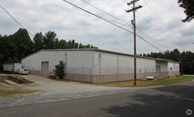
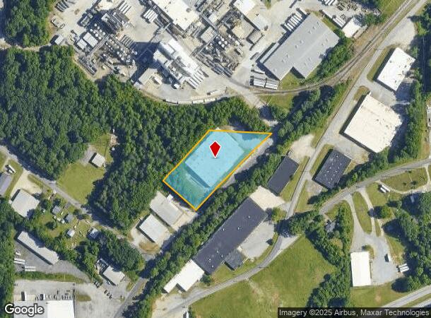
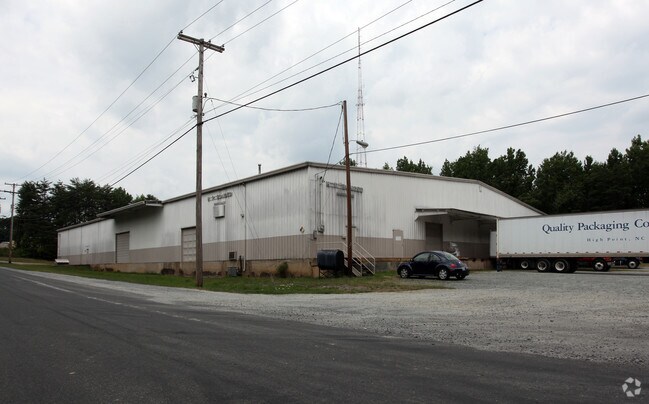
Property Record
1700 Belmar St, High Point, NC 27260
NEARBY LISTINGS FOR SALE OR LEASE
Property Detail
1700 Belmar St
6799-51-5009
Belmar St
Warehouse
BELMAR ST;N SIDE
X
Randolph
3710679900K
North Carolina
2025
1.81 AC
2025
High Point/SW Guilford Cty
031601
Greensboro/Winston-Salem
23,040 SF
Greensboro-High Point, NC
DEMOGRAPHICS near 1700 Belmar St
1 mile
3 mile
5 mile
2024 Total Population
1,605
32,361
99,494
2029 Population
1,638
33,286
102,168
Pop Growth 2024-2029
+ 2.06%
+ 2.86%
+ 2.69%
Average Age
39
39
39
2024 Total Households
670
12,797
38,153
HH Growth 2024-2029
+ 2.09%
+ 2.82%
+ 2.78%
Median Household Inc
$32,500
$48,189
$46,364
Avg Household Size
2.40
2.40
2.40
2024 Avg HH Vehicles
2.00
2.00
2.00
Median Home Value
$107,200
$156,144
$152,030
Median Year Built
1967
1976
1972
Nearby Places
Map Layers
Map Styles
 Street
 Aerial
Transit
 Traffic
 Biking
Places
Listings with unknown addresses are not visible on the map
- Restaurants
- Banks
- Shops
- Fitness
- Groceries
PUBLIC TRANSPORTATION
COMMUTER RAIL
High Point Station (Piedmont - North Carolina by Train (NC Train))
Drive
Walk
Distance
High Point Station (Piedmont - North Carolina by Train (NC Train))
9 min
5.0 mi
AIRPORT
Piedmont Triad International
Drive
Walk
Distance
Piedmont Triad International
32 min
20.7 mi
Nearby Properties
Address
Land Use
TOTAL SIZE
Lot Size
Zoning
Address
Land Use
TOTAL SIZE
Lot Size
Zoning
1,277,656 SF
2.47 AC
CB
Address
Land Use
TOTAL SIZE
Lot Size
Zoning
484,289 SF
6.41 AC
CB
Address
Land Use
TOTAL SIZE
Lot Size
Zoning
796,121 SF
9.36 AC
CB
Address
Land Use
TOTAL SIZE
Lot Size
Zoning
802,214 SF
0.01 AC
CB
Address
Land Use
TOTAL SIZE
Lot Size
Zoning
706,686 SF
39.02 AC
R-5
Address
Land Use
TOTAL SIZE
Lot Size
Zoning
457,534 SF
2.13 AC
CB
Address
Land Use
TOTAL SIZE
Lot Size
Zoning
104,686 SF
12.97 AC
GB
Address
Land Use
TOTAL SIZE
Lot Size
Zoning
355,633 SF
63.42 AC
HI
Address
Land Use
TOTAL SIZE
Lot Size
Zoning
322,779 SF
0.88 AC
CB
Address
Land Use
TOTAL SIZE
Lot Size
Zoning
204,276 SF
68.51 AC
M-2
Address
Land Use
TOTAL SIZE
Lot Size
Zoning
297,676 SF
0.48 AC
CB
Address
Land Use
TOTAL SIZE
Lot Size
Zoning
319,603 SF
1.34 AC
CB
Address
Land Use
TOTAL SIZE
Lot Size
Zoning
196,353 SF
13.76 AC
RC
Address
Land Use
TOTAL SIZE
Lot Size
Zoning
369,312 SF
0.75 AC
CB
Address
Land Use
TOTAL SIZE
Lot Size
Zoning
156,010 SF
36.21 AC
M-1
Address
Land Use
TOTAL SIZE
Lot Size
Zoning
351,736 SF
34.77 AC
HI
Address
Land Use
TOTAL SIZE
Lot Size
Zoning
87,485 SF
17.21 AC
R-3
Address
Land Use
TOTAL SIZE
Lot Size
Zoning
174,529 SF
2.87 AC
CB
Address
Land Use
TOTAL SIZE
Lot Size
Zoning
81,450 SF
1.38 AC
CB
Address
Land Use
TOTAL SIZE
Lot Size
Zoning
233,398 SF
0.48 AC
CB
Address
Land Use
TOTAL SIZE
Lot Size
Zoning
4,500 SF
6.98 AC
MX-D
Address
Land Use
TOTAL SIZE
Lot Size
Zoning
94,632 SF
1.13 AC
MX-D
Address
Land Use
TOTAL SIZE
Lot Size
Zoning
258,695 SF
0.70 AC
CB
Address
Land Use
TOTAL SIZE
Lot Size
Zoning
286,940 SF
1.97 AC
CB
Address
Land Use
TOTAL SIZE
Lot Size
Zoning
105,676 SF
24.20 AC
R-5
Address
Land Use
TOTAL SIZE
Lot Size
Zoning
85,233 SF
4.56 AC
CU-PDM
Address
Land Use
TOTAL SIZE
Lot Size
Zoning
245,194 SF
23.44 AC
LI
Address
Land Use
TOTAL SIZE
Lot Size
Zoning
85,233 SF
4.36 AC
CU-PDM
Address
Land Use
TOTAL SIZE
Lot Size
Zoning
225,254 SF
0.45 AC
CB
Address
Land Use
TOTAL SIZE
Lot Size
Zoning
77,506 SF
2.62 AC
CB
The World's #1 Commercial Real Estate Marketplace
Connect with us
© 2026 CoStar Group
The information above has been obtained from sources believed reliable. While we do not doubt its accuracy we have not verified it and make no guarantee, warranty or representation about it. It is your responsibility to independently confirm its accuracy and completeness. Any projections, opinions, assumptions, or estimates used are for example only and do not represent the current or future performance of the property. The value of this transaction to you depends on tax and other factors which should be evaluated by your tax, financial, and legal advisors. You and your advisors should conduct a careful, independent investigation of the property to determine to your satisfaction the suitability of the property for your needs.