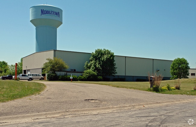
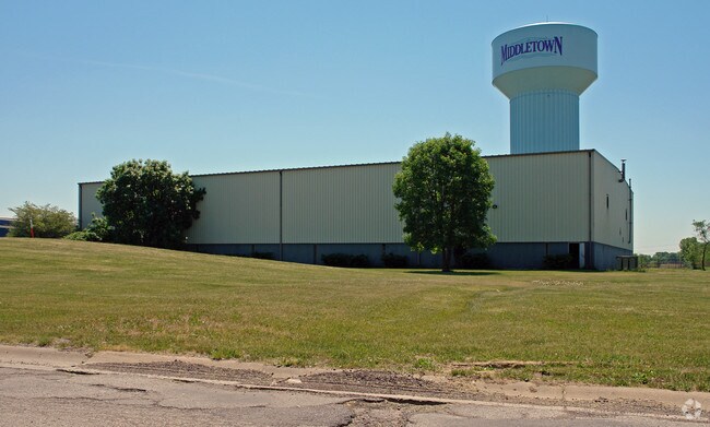
Property Record
1700 Made Dr, Middletown, OH 45044
NEARBY LISTINGS FOR SALE OR LEASE
Property Detail
1700 Made Dr
Q6542-084-000-015
A Land Of 1
Warehouse
16071 N 418.46 OF W 133.08 OF S 1439.51
X
Butler
39017C0209E
Ohio
2024
1.82 AC
2024
Monroe/Middletown
014100
Cincinnati/Dayton
24,704 SF
Cincinnati, OH-KY-IN
DEMOGRAPHICS near 1700 Made Dr
1 Mile
3 Mile
5 Mile
2024 Total Population
1,321
32,448
99,696
2029 Population
1,342
33,072
101,535
Pop Growth 2024-2029
+ 1.59%
+ 1.92%
+ 1.84%
Average Age
39
37
38
2024 Total Households
447
11,901
37,357
HH Growth 2024-2029
+ 1.34%
+ 1.89%
+ 1.89%
Median Household Inc
$92,079
$58,887
$69,183
Avg Household Size
2.80
2.60
2.60
2024 Avg HH Vehicles
2.00
2.00
2.00
Median Home Value
$210,000
$166,594
$187,894
Median Year Built
1990
1969
1974
Nearby Places
Map Layers
Map Styles
 Street
 Aerial
- Restaurants
- Banks
- Shops
- Fitness
- Groceries
PUBLIC TRANSPORTATION
AIRPORT
James M Cox Dayton International
DRIVE
WALK
Distance
James M Cox Dayton International
57 min
40.1 mi
Cincinnati/Northern Kentucky International
DRIVE
WALK
Distance
Cincinnati/Northern Kentucky International
67 min
45.0 mi
SALE & LEASE HISTORY
LISTING DATE
SALE/LEASE

Nov 30, 2021
For Sale
Nearby Properties
Address
Land Use
TOTAL SIZE
Lot Size
Zoning
Address
Land Use
TOTAL SIZE
Lot Size
Zoning
14,558 SF
26.81 AC
Address
Land Use
TOTAL SIZE
Lot Size
Zoning
34.66 AC
Address
Land Use
TOTAL SIZE
Lot Size
Zoning
369,922 SF
28.10 AC
Address
Land Use
TOTAL SIZE
Lot Size
Zoning
40.03 AC
Address
Land Use
TOTAL SIZE
Lot Size
Zoning
12,040 SF
49.57 AC
Address
Land Use
TOTAL SIZE
Lot Size
Zoning
833,210 SF
57.88 AC
Address
Land Use
TOTAL SIZE
Lot Size
Zoning
1,380,095 SF
47.11 AC
Address
Land Use
TOTAL SIZE
Lot Size
Zoning
3,956 SF
186.57 AC
Address
Land Use
TOTAL SIZE
Lot Size
Zoning
57.88 AC
Address
Land Use
TOTAL SIZE
Lot Size
Zoning
334,640 SF
41.28 AC
Address
Land Use
TOTAL SIZE
Lot Size
Zoning
369,922 SF
28.10 AC
Address
Land Use
TOTAL SIZE
Lot Size
Zoning
189,571 SF
10.79 AC
ADV
Address
Land Use
TOTAL SIZE
Lot Size
Zoning
478,217 SF
61.13 AC
Address
Land Use
TOTAL SIZE
Lot Size
Zoning
148,762 SF
5.01 AC
Address
Land Use
TOTAL SIZE
Lot Size
Zoning
402,440 SF
25.46 AC
Address
Land Use
TOTAL SIZE
Lot Size
Zoning
41.28 AC
Address
Land Use
TOTAL SIZE
Lot Size
Zoning
86.47 AC
ADV
Address
Land Use
TOTAL SIZE
Lot Size
Zoning
57,248 SF
224.87 AC
Address
Land Use
TOTAL SIZE
Lot Size
Zoning
235,831 SF
15.01 AC
Address
Land Use
TOTAL SIZE
Lot Size
Zoning
Address
Land Use
TOTAL SIZE
Lot Size
Zoning
33,362 SF
0.73 AC
Address
Land Use
TOTAL SIZE
Lot Size
Zoning
371,743 SF
24.58 AC
ADV
Address
Land Use
TOTAL SIZE
Lot Size
Zoning
9,069 SF
115.70 AC
Address
Land Use
TOTAL SIZE
Lot Size
Zoning
166 AC
ADV
Address
Land Use
TOTAL SIZE
Lot Size
Zoning
73,178 SF
5.12 AC
Address
Land Use
TOTAL SIZE
Lot Size
Zoning
71,525 SF
6.87 AC
Address
Land Use
TOTAL SIZE
Lot Size
Zoning
151,839 SF
1.68 AC
Address
Land Use
TOTAL SIZE
Lot Size
Zoning
161,195 SF
37.71 AC
Address
Land Use
TOTAL SIZE
Lot Size
Zoning
169,399 SF
48.55 AC
Address
Land Use
TOTAL SIZE
Lot Size
Zoning
104,888 SF
7.45 AC
The World's #1 Commercial Real Estate Marketplace
Connect with us
© 2025 CoStar Group
The information above has been obtained from sources believed reliable. While we do not doubt its accuracy we have not verified it and make no guarantee, warranty or representation about it. It is your responsibility to independently confirm its accuracy and completeness. Any projections, opinions, assumptions, or estimates used are for example only and do not represent the current or future performance of the property. The value of this transaction to you depends on tax and other factors which should be evaluated by your tax, financial, and legal advisors. You and your advisors should conduct a careful, independent investigation of the property to determine to your satisfaction the suitability of the property for your needs.