Property Record
1710 Saint Louis Mills Cir, Hazelwood, MO 63042
NEARBY LISTINGS FOR SALE OR LEASE
-
-
-
-
-
No Photo
-
-
View all Hazelwood listings for sale on LoopNet.com
Property Detail
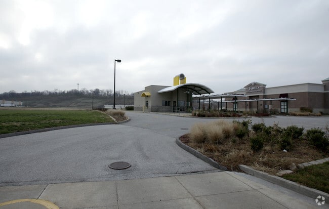
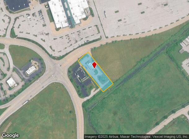
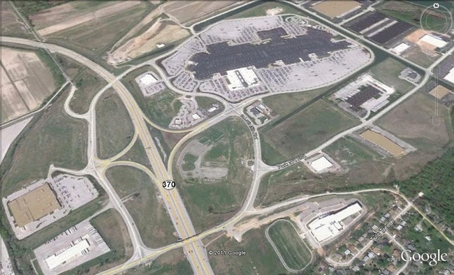
1710 Saint Louis Mills Cir
St. Louis, MO-IL
St Louis Mills Park
09N-64-0260
ST LOUIS MILLS PARK LOT S-3
Restaurantbuilding
St. Louis
X
Missouri
29183C0295G
s-3
2023
1.19 AC
2025
North County
211401
St. Louis
1,566 SF
DEMOGRAPHICS near 1710 Saint Louis Mills Cir
1 Mile
3 Mile
5 Mile
2024 Total Population
2,110
21,483
117,707
2029 Population
2,062
21,093
117,714
Pop Growth 2024-2029
(2.27%)
(1.82%)
+ 0.01%
Average Age
41
40
40
2024 Total Households
935
9,316
49,175
HH Growth 2024-2029
(2.35%)
(1.90%)
(0.02%)
Median Household Inc
$52,747
$57,569
$60,972
Avg Household Size
2.20
2.20
2.30
2024 Avg HH Vehicles
2.00
2.00
2.00
Median Home Value
$143,674
$170,163
$167,882
Median Year Built
1966
1970
1966
Nearby Places
- Restaurants
- Banks
- Shops
- Fitness
- Groceries
PUBLIC TRANSPORTATION
AIRPORT
St Louis Lambert International
DRIVE
WALK
Distance
St Louis Lambert International
12 min
6.5 mi
Freight Ports
Port Milwaukee
DRIVE
WALK
Distance
Port Milwaukee
431 min
379.6 mi
Nearby Properties
Address
Land Use
TOTAL SIZE
Lot Size
Zoning
Address
Land Use
TOTAL SIZE
Lot Size
Zoning
449,698 SF
47.19 AC
R3
Address
Land Use
TOTAL SIZE
Lot Size
Zoning
4,416 SF
54.81 AC
80B
Address
Land Use
TOTAL SIZE
Lot Size
Zoning
833,525 SF
25.53 AC
R1
Address
Land Use
TOTAL SIZE
Lot Size
Zoning
893,188 SF
71.88 AC
G
Address
Land Use
TOTAL SIZE
Lot Size
Zoning
564,552 SF
42.07 AC
10M-1
Address
Land Use
TOTAL SIZE
Lot Size
Zoning
528,000 SF
21.10 AC
80I
Address
Land Use
TOTAL SIZE
Lot Size
Zoning
542,500 SF
39.91 AC
FPNU
Address
Land Use
TOTAL SIZE
Lot Size
Zoning
662,199 SF
26.58 AC
10M-1
Address
Land Use
TOTAL SIZE
Lot Size
Zoning
319,398 SF
15.58 AC
10M-3
Address
Land Use
TOTAL SIZE
Lot Size
Zoning
448,590 SF
24.75 AC
M3
Address
Land Use
TOTAL SIZE
Lot Size
Zoning
158,499 SF
27.01 AC
FPM3
Address
Land Use
TOTAL SIZE
Lot Size
Zoning
491,800 SF
18.69 AC
80AG
Address
Land Use
TOTAL SIZE
Lot Size
Zoning
67,891 SF
4 AC
R3
Address
Land Use
TOTAL SIZE
Lot Size
Zoning
406,000 SF
18.82 AC
80CA
Address
Land Use
TOTAL SIZE
Lot Size
Zoning
317,145 SF
21.71 AC
10M-1
Address
Land Use
TOTAL SIZE
Lot Size
Zoning
403,200 SF
21.99 AC
10M-1
Address
Land Use
TOTAL SIZE
Lot Size
Zoning
445,715 SF
28.16 AC
80I
Address
Land Use
TOTAL SIZE
Lot Size
Zoning
343,900 SF
19.62 AC
80AG
Address
Land Use
TOTAL SIZE
Lot Size
Zoning
119,925 SF
72.26 AC
10M-1
Address
Land Use
TOTAL SIZE
Lot Size
Zoning
494,400 SF
26.26 AC
FPM3
Address
Land Use
TOTAL SIZE
Lot Size
Zoning
318,468 SF
17.52 AC
10M-3
Address
Land Use
TOTAL SIZE
Lot Size
Zoning
293,622 SF
28.06 AC
H
Address
Land Use
TOTAL SIZE
Lot Size
Zoning
161,536 SF
7.91 AC
R5
Address
Land Use
TOTAL SIZE
Lot Size
Zoning
269,258 SF
89.80 AC
80F
Address
Land Use
TOTAL SIZE
Lot Size
Zoning
534,068 SF
39.76 AC
M1
Address
Land Use
TOTAL SIZE
Lot Size
Zoning
216,000 SF
16.42 AC
80AG
Address
Land Use
TOTAL SIZE
Lot Size
Zoning
130,500 SF
10.68 AC
FPM3
Address
Land Use
TOTAL SIZE
Lot Size
Zoning
388,768 SF
25.96 AC
FPM3
Address
Land Use
TOTAL SIZE
Lot Size
Zoning
135,721 SF
5.40 AC
80F
Address
Land Use
TOTAL SIZE
Lot Size
Zoning
278,550 SF
18 AC
10M-1
The World's #1 Commercial Real Estate Marketplace
Connect with us
© 2025 CoStar Group
The information above has been obtained from sources believed reliable. While we do not doubt its accuracy we have not verified it and make no guarantee, warranty or representation about it. It is your responsibility to independently confirm its accuracy and completeness. Any projections, opinions, assumptions, or estimates used are for example only and do not represent the current or future performance of the property. The value of this transaction to you depends on tax and other factors which should be evaluated by your tax, financial, and legal advisors. You and your advisors should conduct a careful, independent investigation of the property to determine to your satisfaction the suitability of the property for your needs.