Property Record
1700 Us Highway 50, Silver Springs, NV 89429


NEARBY LISTINGS FOR SALE OR LEASE
-
-
View all Silver Springs listings for sale on LoopNet.com
Property Detail
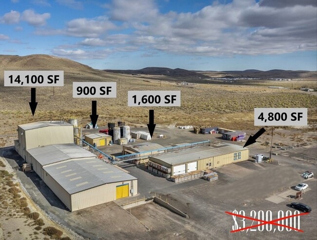
1700 Us Highway 50
015-271-17
Division Of Large Parcels
Lightindustrial
VAQUERO SUPPLEMENT
X
Lyon
32019C0212E
Nevada
2026
12.28 AC
2025
S Lyon County
960206
Reno/Sparks
4,800 SF
Fernley, NV
DEMOGRAPHICS near 1700 Us Highway 50
1 Mile
3 Mile
5 Mile
2024 Total Population
949
2,770
4,071
2029 Population
1,051
3,088
4,541
Pop Growth 2024-2029
+ 10.75%
+ 11.48%
+ 11.55%
Average Age
42
44
44
2024 Total Households
342
1,051
1,565
HH Growth 2024-2029
+ 10.82%
+ 11.51%
+ 11.63%
Median Household Inc
$55,000
$35,985
$37,000
Avg Household Size
2.60
2.50
2.50
2024 Avg HH Vehicles
2.00
2.00
2.00
Median Home Value
$274,218
$254,973
$268,019
Median Year Built
1980
1988
1990
Nearby Places
Map Layers
Map Styles
 Street
 Aerial
- Restaurants
- Banks
- Shops
- Fitness
- Groceries
PUBLIC TRANSPORTATION
AIRPORT
Reno/Tahoe International
DRIVE
WALK
Distance
Reno/Tahoe International
75 min
45.9 mi
Freight Ports
Port of Stockton
DRIVE
WALK
Distance
Port of Stockton
260 min
220.2 mi
SALE & LEASE HISTORY
LISTING DATE
SALE/LEASE

Nov 08, 2023
For Sale
Nearby Properties
Address
Land Use
TOTAL SIZE
Lot Size
Zoning
Address
Land Use
TOTAL SIZE
Lot Size
Zoning
142,800 SF
26.66 AC
M1
Address
Land Use
TOTAL SIZE
Lot Size
Zoning
2,585 SF
4.94 AC
RR2T
Address
Land Use
TOTAL SIZE
Lot Size
Zoning
3,600 SF
1.23 AC
M1
Address
Land Use
TOTAL SIZE
Lot Size
Zoning
2.07 AC
RR5
Address
Land Use
TOTAL SIZE
Lot Size
Zoning
1,064 SF
5.08 AC
M1
Address
Land Use
TOTAL SIZE
Lot Size
Zoning
15,398 SF
29.03 AC
EMU
Address
Land Use
TOTAL SIZE
Lot Size
Zoning
5,076 SF
11.52 AC
M1
Address
Land Use
TOTAL SIZE
Lot Size
Zoning
9,936 SF
1.52 AC
C2
Address
Land Use
TOTAL SIZE
Lot Size
Zoning
8,000 SF
4.35 AC
RR3T
Address
Land Use
TOTAL SIZE
Lot Size
Zoning
8,676 SF
1.02 AC
C2
Address
Land Use
TOTAL SIZE
Lot Size
Zoning
2,676 SF
2.55 AC
NR2
Address
Land Use
TOTAL SIZE
Lot Size
Zoning
6,832 SF
1.66 AC
C2
Address
Land Use
TOTAL SIZE
Lot Size
Zoning
9,230 SF
1.10 AC
C2
Address
Land Use
TOTAL SIZE
Lot Size
Zoning
5,760 SF
2.33 AC
M1
Address
Land Use
TOTAL SIZE
Lot Size
Zoning
7,000 SF
0.80 AC
C2
Address
Land Use
TOTAL SIZE
Lot Size
Zoning
6,850 SF
1.99 AC
M1
Address
Land Use
TOTAL SIZE
Lot Size
Zoning
10,758 SF
0.60 AC
C2
Address
Land Use
TOTAL SIZE
Lot Size
Zoning
5,400 SF
5.54 AC
CC
Address
Land Use
TOTAL SIZE
Lot Size
Zoning
48.18 AC
MULT
Address
Land Use
TOTAL SIZE
Lot Size
Zoning
8,000 SF
0.80 AC
C2
Address
Land Use
TOTAL SIZE
Lot Size
Zoning
2,280 SF
389.49 AC
M1
Address
Land Use
TOTAL SIZE
Lot Size
Zoning
10 AC
MULT
Address
Land Use
TOTAL SIZE
Lot Size
Zoning
3.76 AC
C2
Address
Land Use
TOTAL SIZE
Lot Size
Zoning
2,400 SF
5.65 AC
M1
Address
Land Use
TOTAL SIZE
Lot Size
Zoning
836 SF
0.74 AC
C2
Address
Land Use
TOTAL SIZE
Lot Size
Zoning
17.37 AC
E1T
Address
Land Use
TOTAL SIZE
Lot Size
Zoning
12,960 SF
4.06 AC
M1
Address
Land Use
TOTAL SIZE
Lot Size
Zoning
20.41 AC
MULT
Address
Land Use
TOTAL SIZE
Lot Size
Zoning
3,240 SF
0.57 AC
C2
The World's #1 Commercial Real Estate Marketplace
Connect with us
© 2026 CoStar Group
The information above has been obtained from sources believed reliable. While we do not doubt its accuracy we have not verified it and make no guarantee, warranty or representation about it. It is your responsibility to independently confirm its accuracy and completeness. Any projections, opinions, assumptions, or estimates used are for example only and do not represent the current or future performance of the property. The value of this transaction to you depends on tax and other factors which should be evaluated by your tax, financial, and legal advisors. You and your advisors should conduct a careful, independent investigation of the property to determine to your satisfaction the suitability of the property for your needs.