Property Record
1700 Highway 36 W, Saint Paul, MN 55113


NEARBY LISTINGS FOR SALE OR LEASE
Property Detail
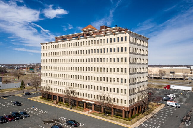
1700 Highway 36 W
Minneapolis-St. Paul-Bloomington, MN-WI
Rosewood Village
09-29-23-43-0001
ROSEWOOD VILLAGE LOT 2 BLK 1
Officebuilding
Ramsey
X
Minnesota
27053C0250F
2
2024
4.64 AC
2025
Suburban St Paul
041301
Minneapolis/St Paul
94,719 SF
DEMOGRAPHICS near 1700 Highway 36 W
1 Mile
3 Mile
5 Mile
2024 Total Population
6,631
80,015
348,149
2029 Population
6,432
78,005
341,536
Pop Growth 2024-2029
(3.00%)
(2.51%)
(1.90%)
Average Age
42
41
37
2024 Total Households
2,820
33,957
144,288
HH Growth 2024-2029
(3.23%)
(2.68%)
(1.97%)
Median Household Inc
$84,375
$82,805
$68,168
Avg Household Size
2.20
2.20
2.20
2024 Avg HH Vehicles
2.00
2.00
2.00
Median Home Value
$355,366
$323,873
$303,735
Median Year Built
1962
1964
1966
Nearby Places
Map Layers
Map Styles
 Street
 Aerial
- Restaurants
- Banks
- Shops
- Fitness
- Groceries
PUBLIC TRANSPORTATION
COMMUTER RAIL
Target Field Station (Northstar Corridor - Northstar Commuter Rail)
DRIVE
WALK
Distance
Target Field Station (Northstar Corridor - Northstar Commuter Rail)
15 min
7.7 mi
DRIVE
WALK
Distance
14 min
9.3 mi
AIRPORT
Minneapolis-St Paul International/Wold-Chamberlain
DRIVE
WALK
Distance
Minneapolis-St Paul International/Wold-Chamberlain
25 min
11.6 mi
SALE & LEASE HISTORY
LISTING DATE
SALE/LEASE

Sep 25, 2019
For Lease
Jun 15, 2022
For Lease
Jan 13, 2017
For Lease
Feb 06, 2017
For Lease
Aug 23, 2018
For Lease
Nearby Properties
Address
Land Use
TOTAL SIZE
Lot Size
Zoning
Address
Land Use
TOTAL SIZE
Lot Size
Zoning
36,300 SF
223.37 AC
Address
Land Use
TOTAL SIZE
Lot Size
Zoning
37.24 AC
Address
Land Use
TOTAL SIZE
Lot Size
Zoning
Address
Land Use
TOTAL SIZE
Lot Size
Zoning
18.24 AC
Address
Land Use
TOTAL SIZE
Lot Size
Zoning
48.52 AC
Address
Land Use
TOTAL SIZE
Lot Size
Zoning
294,047 SF
7.99 AC
Address
Land Use
TOTAL SIZE
Lot Size
Zoning
4,808 SF
269.81 AC
Address
Land Use
TOTAL SIZE
Lot Size
Zoning
476,695 SF
21.51 AC
Address
Land Use
TOTAL SIZE
Lot Size
Zoning
18,630 SF
22.02 AC
Address
Land Use
TOTAL SIZE
Lot Size
Zoning
276,144 SF
347.68 AC
Address
Land Use
TOTAL SIZE
Lot Size
Zoning
220 SF
19.66 AC
Address
Land Use
TOTAL SIZE
Lot Size
Zoning
462,598 SF
17.20 AC
I2
Address
Land Use
TOTAL SIZE
Lot Size
Zoning
658,453 SF
40.22 AC
Address
Land Use
TOTAL SIZE
Lot Size
Zoning
Address
Land Use
TOTAL SIZE
Lot Size
Zoning
792 SF
42.69 AC
Address
Land Use
TOTAL SIZE
Lot Size
Zoning
2,296 SF
128.65 AC
Address
Land Use
TOTAL SIZE
Lot Size
Zoning
419,070 SF
45.50 AC
Address
Land Use
TOTAL SIZE
Lot Size
Zoning
167,511 SF
14.49 AC
Address
Land Use
TOTAL SIZE
Lot Size
Zoning
335,252 SF
19.06 AC
Address
Land Use
TOTAL SIZE
Lot Size
Zoning
294,500 SF
5.95 AC
Address
Land Use
TOTAL SIZE
Lot Size
Zoning
201,030 SF
7.59 AC
Address
Land Use
TOTAL SIZE
Lot Size
Zoning
170,875 SF
2.76 AC
Address
Land Use
TOTAL SIZE
Lot Size
Zoning
150,341 SF
12.86 AC
C3S
Address
Land Use
TOTAL SIZE
Lot Size
Zoning
6.11 AC
Address
Land Use
TOTAL SIZE
Lot Size
Zoning
272,002 SF
8.16 AC
Address
Land Use
TOTAL SIZE
Lot Size
Zoning
404,642 SF
15.97 AC
Address
Land Use
TOTAL SIZE
Lot Size
Zoning
599,778 SF
21.76 AC
I2
Address
Land Use
TOTAL SIZE
Lot Size
Zoning
Address
Land Use
TOTAL SIZE
Lot Size
Zoning
25,523 SF
135.18 AC
Address
Land Use
TOTAL SIZE
Lot Size
Zoning
25,699 SF
1.69 AC
The World's #1 Commercial Real Estate Marketplace
Connect with us
© 2026 CoStar Group
The information above has been obtained from sources believed reliable. While we do not doubt its accuracy we have not verified it and make no guarantee, warranty or representation about it. It is your responsibility to independently confirm its accuracy and completeness. Any projections, opinions, assumptions, or estimates used are for example only and do not represent the current or future performance of the property. The value of this transaction to you depends on tax and other factors which should be evaluated by your tax, financial, and legal advisors. You and your advisors should conduct a careful, independent investigation of the property to determine to your satisfaction the suitability of the property for your needs.