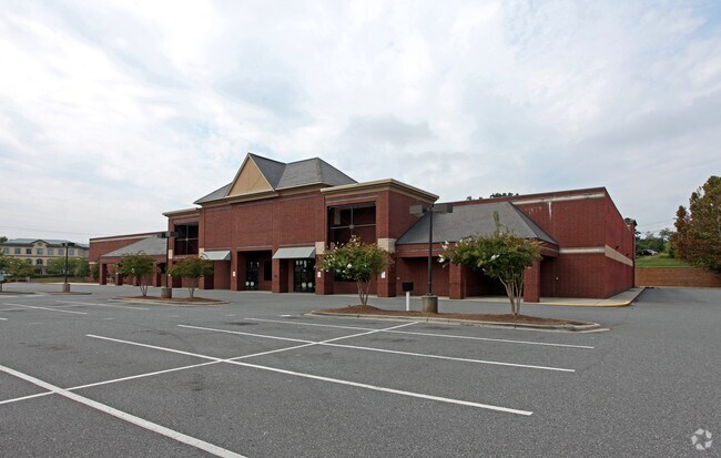
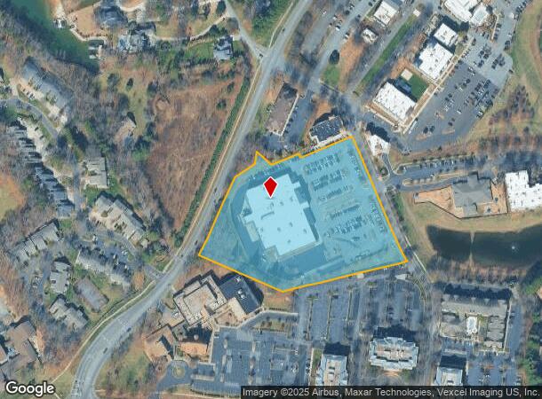
Property Record
17001 Kenton Dr, Cornelius, NC 28031


NEARBY LISTINGS FOR SALE OR LEASE
Property Detail
17001 Kenton Dr
Charlotte-Concord-Gastonia, NC-SC
Gary S Cangelosi&Joseph H Call
005-061-08
TRACT O & M & PK M31-469
Commercialnec
Mecklenburg
X
North Carolina
3710463200K
8
2024
5.86 AC
2025
North
006209
Charlotte
51,098 SF
DEMOGRAPHICS near 17001 Kenton Dr
1 Mile
3 Mile
5 Mile
2024 Total Population
7,664
50,274
102,350
2029 Population
8,068
52,885
108,544
Pop Growth 2024-2029
+ 5.27%
+ 5.19%
+ 6.05%
Average Age
42
40
40
2024 Total Households
3,738
20,230
40,351
HH Growth 2024-2029
+ 5.38%
+ 5.25%
+ 6.11%
Median Household Inc
$103,551
$104,826
$108,022
Avg Household Size
2.00
2.50
2.50
2024 Avg HH Vehicles
2.00
2.00
2.00
Median Home Value
$427,842
$401,983
$407,522
Median Year Built
1997
2000
2001
Nearby Places
Map Layers
Map Styles
 Street
 Aerial
- Restaurants
- Banks
- Shops
- Fitness
- Groceries
PUBLIC TRANSPORTATION
AIRPORT
Concord-Padgett Regional
DRIVE
WALK
Distance
Concord-Padgett Regional
24 min
15.5 mi
Charlotte/Douglas International
DRIVE
WALK
Distance
Charlotte/Douglas International
35 min
23.5 mi
Freight Ports
North Charleston Terminal
DRIVE
WALK
Distance
North Charleston Terminal
246 min
215.7 mi
SALE & LEASE HISTORY
LISTING DATE
SALE/LEASE

Sep 25, 2016
For Lease
Aug 03, 2017
For Lease
Apr 12, 2017
For Lease
Nearby Properties
Address
Land Use
TOTAL SIZE
Lot Size
Zoning
Address
Land Use
TOTAL SIZE
Lot Size
Zoning
395,706 SF
23.38 AC
NRCD
Address
Land Use
TOTAL SIZE
Lot Size
Zoning
4,552 SF
92.49 AC
HC(CD)
Address
Land Use
TOTAL SIZE
Lot Size
Zoning
222,382 SF
31.89 AC
NR
Address
Land Use
TOTAL SIZE
Lot Size
Zoning
280,344 SF
21.36 AC
NRCD
Address
Land Use
TOTAL SIZE
Lot Size
Zoning
339,268 SF
21.80 AC
NR
Address
Land Use
TOTAL SIZE
Lot Size
Zoning
223,720 SF
18.42 AC
VC
Address
Land Use
TOTAL SIZE
Lot Size
Zoning
187,250 SF
22.35 AC
NR
Address
Land Use
TOTAL SIZE
Lot Size
Zoning
292,144 SF
25.33 AC
NRCD
Address
Land Use
TOTAL SIZE
Lot Size
Zoning
360,243 SF
26.30 AC
HCCD
Address
Land Use
TOTAL SIZE
Lot Size
Zoning
200,768 SF
3.86 AC
HCCD
Address
Land Use
TOTAL SIZE
Lot Size
Zoning
239,596 SF
19.24 AC
NMX
Address
Land Use
TOTAL SIZE
Lot Size
Zoning
202,245 SF
14.55 AC
NRCD
Address
Land Use
TOTAL SIZE
Lot Size
Zoning
139,697 SF
19.75 AC
NR
Address
Land Use
TOTAL SIZE
Lot Size
Zoning
120,661 SF
10.50 AC
HC(CD)
Address
Land Use
TOTAL SIZE
Lot Size
Zoning
167,122 SF
5.62 AC
Address
Land Use
TOTAL SIZE
Lot Size
Zoning
156,092 SF
17.20 AC
NRCD
Address
Land Use
TOTAL SIZE
Lot Size
Zoning
204,216 SF
3.29 AC
HCCD
Address
Land Use
TOTAL SIZE
Lot Size
Zoning
180,542 SF
3.50 AC
HCCD
Address
Land Use
TOTAL SIZE
Lot Size
Zoning
108,153 SF
4.70 AC
TND-U(CD)
Address
Land Use
TOTAL SIZE
Lot Size
Zoning
Address
Land Use
TOTAL SIZE
Lot Size
Zoning
139,665 SF
14.37 AC
HC
Address
Land Use
TOTAL SIZE
Lot Size
Zoning
109,316 SF
7.03 AC
NR
Address
Land Use
TOTAL SIZE
Lot Size
Zoning
107,528 SF
6.90 AC
HCCD
Address
Land Use
TOTAL SIZE
Lot Size
Zoning
62,877 SF
68 AC
CI
Address
Land Use
TOTAL SIZE
Lot Size
Zoning
85,617 SF
12.36 AC
VC
Address
Land Use
TOTAL SIZE
Lot Size
Zoning
127,743 SF
3.95 AC
VC(CD)
Address
Land Use
TOTAL SIZE
Lot Size
Zoning
81,162 SF
41.09 AC
NR
Address
Land Use
TOTAL SIZE
Lot Size
Zoning
98,895 SF
4.36 AC
Address
Land Use
TOTAL SIZE
Lot Size
Zoning
83,624 SF
6.35 AC
Address
Land Use
TOTAL SIZE
Lot Size
Zoning
83,520 SF
3.98 AC
NR
The World's #1 Commercial Real Estate Marketplace
Connect with us
© 2026 CoStar Group
The information above has been obtained from sources believed reliable. While we do not doubt its accuracy we have not verified it and make no guarantee, warranty or representation about it. It is your responsibility to independently confirm its accuracy and completeness. Any projections, opinions, assumptions, or estimates used are for example only and do not represent the current or future performance of the property. The value of this transaction to you depends on tax and other factors which should be evaluated by your tax, financial, and legal advisors. You and your advisors should conduct a careful, independent investigation of the property to determine to your satisfaction the suitability of the property for your needs.