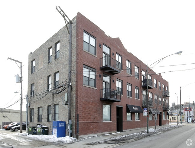
Property Record
1560 W Wabansia Ave, Chicago, IL 60642

NEARBY LISTINGS FOR SALE OR LEASE
Property Detail
1560 W Wabansia Ave
Chicago
Glove Co Lofts Condo
Chicago-Naperville-Elgin, IL-IN-WI
Cook
14-32-306-024-1021
Illinois
Condominium
0.28 AC
X
North Branch/Goose Island
17031C0416J
DEMOGRAPHICS near 1560 W Wabansia Ave
1 Mile
3 Mile
5 Mile
2024 Total Population
53,602
568,812
1,097,799
2029 Population
51,927
553,266
1,055,651
Pop Growth 2024-2029
(3.12%)
(2.73%)
(3.84%)
Average Age
33
36
37
2024 Total Households
24,902
294,791
522,103
HH Growth 2024-2029
(3.50%)
(2.70%)
(3.62%)
Median Household Inc
$145,751
$107,785
$89,472
Avg Household Size
2.10
1.90
2.00
2024 Avg HH Vehicles
1.00
1.00
1.00
Median Home Value
$696,883
$532,073
$444,779
Median Year Built
1964
1970
1960
Nearby Places
Map Layers
Map Styles
 Street
 Aerial
- Restaurants
- Banks
- Shops
- Fitness
- Groceries
PUBLIC TRANSPORTATION
TRANSIT/SUBWAY
Division Station (Blue Line - Chicago Transit Authority "L" Trains (The "L"))
DRIVE
WALK
Distance
Division Station (Blue Line - Chicago Transit Authority "L" Trains (The "L"))
1 min
12 min
0.6 mi
Damen Station (Blue Line) (Blue Line - Chicago Transit Authority "L" Trains (The "L"))
DRIVE
WALK
Distance
Damen Station (Blue Line) (Blue Line - Chicago Transit Authority "L" Trains (The "L"))
2 min
13 min
0.7 mi
North/Clybourn Station (Red Line - Chicago Transit Authority "L" Trains (The "L"))
DRIVE
WALK
Distance
North/Clybourn Station (Red Line - Chicago Transit Authority "L" Trains (The "L"))
2 min
20 min
1.1 mi
Armitage Station (Brown Line - Chicago Transit Authority "L" Trains (The "L"), Purple Line - Chicago Transit Authority "L" Trains (The "L"))
DRIVE
WALK
Distance
Armitage Station (Brown Line - Chicago Transit Authority "L" Trains (The "L"), Purple Line - Chicago Transit Authority "L" Trains (The "L"))
3 min
20 min
1.1 mi
COMMUTER RAIL
Clybourn Station (Union Pacific North Line - Northeast Illinois Regional Commuter Railroad (Metra), Union Pacific Northwest Line - Northeast Illinois Regional Commuter Railroad (Metra))
DRIVE
WALK
Distance
Clybourn Station (Union Pacific North Line - Northeast Illinois Regional Commuter Railroad (Metra), Union Pacific Northwest Line - Northeast Illinois Regional Commuter Railroad (Metra))
0 min
6 min
0.3 mi
Western Avenue Station (Md-N/Md-W/Ncs) (Milwaukee District North Line - Northeast Illinois Regional Commuter Railroad (Metra), Milwaukee District West Line - Northeast Illinois Regional Commuter Railroad (Metra), North Central Service - Northeast Illinois Regional Commuter Railroad (Metra))
DRIVE
WALK
Distance
Western Avenue Station (Md-N/Md-W/Ncs) (Milwaukee District North Line - Northeast Illinois Regional Commuter Railroad (Metra), Milwaukee District West Line - Northeast Illinois Regional Commuter Railroad (Metra), North Central Service - Northeast Illinois Regional Commuter Railroad (Metra))
6 min
2.8 mi
AIRPORT
Chicago Midway International
DRIVE
WALK
Distance
Chicago Midway International
20 min
11.3 mi
Chicago O'Hare International
DRIVE
WALK
Distance
Chicago O'Hare International
22 min
14.5 mi
Freight Ports
Port Milwaukee
DRIVE
WALK
Distance
Port Milwaukee
100 min
82.8 mi
SALE & LEASE HISTORY
LISTING DATE
SALE/LEASE

Apr 10, 2019
For Sale
Apr 10, 2019
For Lease
Nearby Properties
Address
Land Use
TOTAL SIZE
Lot Size
Zoning
Address
Land Use
TOTAL SIZE
Lot Size
Zoning
4,667,723 SF
2.94 AC
DC-16
Address
Land Use
TOTAL SIZE
Lot Size
Zoning
1,546,909 SF
0.98 AC
PD 1369
Address
Land Use
TOTAL SIZE
Lot Size
Zoning
1,496,448 SF
2 AC
PD 376
Address
Land Use
TOTAL SIZE
Lot Size
Zoning
1,396,750 SF
4.09 AC
PD 98
Address
Land Use
TOTAL SIZE
Lot Size
Zoning
1,362,475 SF
1.97 AC
PD 1226
Address
Land Use
TOTAL SIZE
Lot Size
Zoning
4,296,046 SF
6.15 AC
DC-16
Address
Land Use
TOTAL SIZE
Lot Size
Zoning
3,914,400 SF
5.70 AC
DC-16
Address
Land Use
TOTAL SIZE
Lot Size
Zoning
1,810,145 SF
1.03 AC
PD 365
Address
Land Use
TOTAL SIZE
Lot Size
Zoning
3,090,691 SF
3.30 AC
PD 377,PD
Address
Land Use
TOTAL SIZE
Lot Size
Zoning
0.82 AC
PD 1115
Address
Land Use
TOTAL SIZE
Lot Size
Zoning
0.88 AC
DC-16,PD 9
Address
Land Use
TOTAL SIZE
Lot Size
Zoning
2,750,656 SF
6.29 AC
PD 1065
Address
Land Use
TOTAL SIZE
Lot Size
Zoning
831,084 SF
2.05 AC
PD 316
Address
Land Use
TOTAL SIZE
Lot Size
Zoning
1,888,207 SF
2.03 AC
PD 264
Address
Land Use
TOTAL SIZE
Lot Size
Zoning
1,600,546 SF
1.04 AC
PD 191
Address
Land Use
TOTAL SIZE
Lot Size
Zoning
1,231,710 SF
2.01 AC
PD 27
Address
Land Use
TOTAL SIZE
Lot Size
Zoning
2,429,909 SF
2.93 AC
PD 882
Address
Land Use
TOTAL SIZE
Lot Size
Zoning
2,456,900 SF
0.96 AC
PD 256
Address
Land Use
TOTAL SIZE
Lot Size
Zoning
2,612,517 SF
1.28 AC
PD 256
Address
Land Use
TOTAL SIZE
Lot Size
Zoning
1,272,928 SF
2.33 AC
PD 368
Address
Land Use
TOTAL SIZE
Lot Size
Zoning
1.23 AC
PD 291
Address
Land Use
TOTAL SIZE
Lot Size
Zoning
1,502,279 SF
3.79 AC
PD 98
Address
Land Use
TOTAL SIZE
Lot Size
Zoning
1,559,966 SF
1.38 AC
DC-12
Address
Land Use
TOTAL SIZE
Lot Size
Zoning
1,493,502 SF
1.31 AC
PD 70
Address
Land Use
TOTAL SIZE
Lot Size
Zoning
1,316,385 SF
0.76 AC
PD 381
Address
Land Use
TOTAL SIZE
Lot Size
Zoning
1,571,900 SF
0.59 AC
PD 382
Address
Land Use
TOTAL SIZE
Lot Size
Zoning
1,300,110 SF
1.52 AC
PD 70
Address
Land Use
TOTAL SIZE
Lot Size
Zoning
1,578,363 SF
2.62 AC
DX-12
Address
Land Use
TOTAL SIZE
Lot Size
Zoning
1,109,372 SF
1.66 AC
PD 368
Address
Land Use
TOTAL SIZE
Lot Size
Zoning
1,051,000 SF
0.93 AC
PD 325
The World's #1 Commercial Real Estate Marketplace
Connect with us
© 2026 CoStar Group
The information above has been obtained from sources believed reliable. While we do not doubt its accuracy we have not verified it and make no guarantee, warranty or representation about it. It is your responsibility to independently confirm its accuracy and completeness. Any projections, opinions, assumptions, or estimates used are for example only and do not represent the current or future performance of the property. The value of this transaction to you depends on tax and other factors which should be evaluated by your tax, financial, and legal advisors. You and your advisors should conduct a careful, independent investigation of the property to determine to your satisfaction the suitability of the property for your needs.