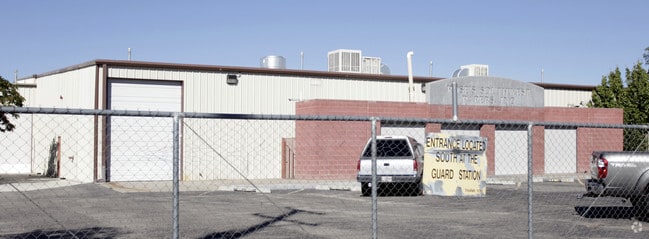
Property Record
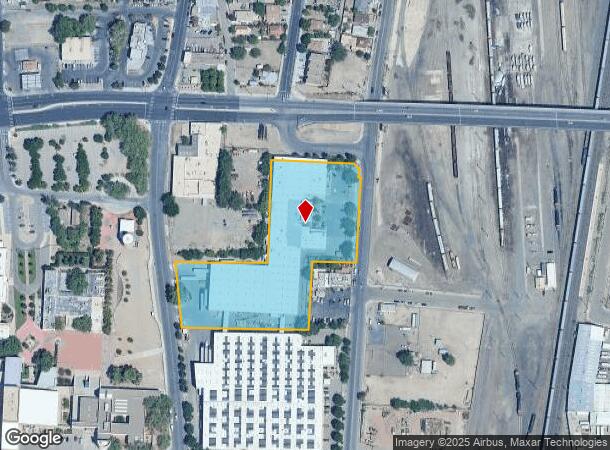
1701 2Nd St Sw, Albuquerque, NM 87102

NEARBY LISTINGS FOR SALE OR LEASE
Property Detail
1701 2Nd St Sw
1-014-056-125364-2-07-02
Unit One South Barelas Industrial Park
Warehouse
TR E-1-A-1 PLAT OF TR E-1-A SOUTH BARELAS INDUSTRIAL PARK UNIT 1 (AKA TR E-1-A EXC THE S'LY PORT) CONT 4.2113 AC
X
Bernalillo
35001C0334G
New Mexico
2024
4.21 AC
2025
South Valley
004001
Albuquerque
95,265 SF
Albuquerque, NM
DEMOGRAPHICS near 1701 2Nd St Sw
1 Mile
3 Mile
5 Mile
2024 Total Population
11,374
82,954
227,648
2029 Population
11,407
83,207
227,370
Pop Growth 2024-2029
+ 0.29%
+ 0.30%
(0.12%)
Average Age
40
39
39
2024 Total Households
4,835
36,114
95,543
HH Growth 2024-2029
+ 0.35%
+ 0.42%
(0.02%)
Median Household Inc
$34,408
$42,529
$45,840
Avg Household Size
2.20
2.10
2.30
2024 Avg HH Vehicles
2.00
2.00
2.00
Median Home Value
$166,748
$237,172
$217,061
Median Year Built
1959
1965
1972
Nearby Places
Map Layers
Map Styles
 Street
 Aerial
- Restaurants
- Banks
- Shops
- Fitness
- Groceries
PUBLIC TRANSPORTATION
COMMUTER RAIL
Downtown Albuquerque (Rail Runner Express - New Mexico Rail Runner Express)
DRIVE
WALK
Distance
Downtown Albuquerque (Rail Runner Express - New Mexico Rail Runner Express)
3 min
1.2 mi
Bernalillo County-International Sunport (Rail Runner Express - New Mexico Rail Runner Express)
DRIVE
WALK
Distance
Bernalillo County-International Sunport (Rail Runner Express - New Mexico Rail Runner Express)
5 min
2.7 mi
AIRPORT
Albuquerque International Sunport
DRIVE
WALK
Distance
Albuquerque International Sunport
23 min
8.9 mi
Nearby Properties
Address
Land Use
TOTAL SIZE
Lot Size
Zoning
Address
Land Use
TOTAL SIZE
Lot Size
Zoning
2,286.01 AC
Address
Land Use
TOTAL SIZE
Lot Size
Zoning
607,287 SF
8.26 AC
Address
Land Use
TOTAL SIZE
Lot Size
Zoning
18,420 SF
18.94 AC
Address
Land Use
TOTAL SIZE
Lot Size
Zoning
849,036 SF
8.12 AC
Address
Land Use
TOTAL SIZE
Lot Size
Zoning
Address
Land Use
TOTAL SIZE
Lot Size
Zoning
Address
Land Use
TOTAL SIZE
Lot Size
Zoning
4,284 SF
47.29 AC
Address
Land Use
TOTAL SIZE
Lot Size
Zoning
4,279 SF
13.72 AC
Address
Land Use
TOTAL SIZE
Lot Size
Zoning
179,231 SF
1,213.98 AC
Address
Land Use
TOTAL SIZE
Lot Size
Zoning
472,156 SF
1.78 AC
Address
Land Use
TOTAL SIZE
Lot Size
Zoning
Address
Land Use
TOTAL SIZE
Lot Size
Zoning
37,700 SF
4.43 AC
Address
Land Use
TOTAL SIZE
Lot Size
Zoning
Address
Land Use
TOTAL SIZE
Lot Size
Zoning
355,645 SF
11.98 AC
Address
Land Use
TOTAL SIZE
Lot Size
Zoning
287,781 SF
38.18 AC
Address
Land Use
TOTAL SIZE
Lot Size
Zoning
381,985 SF
1.84 AC
Address
Land Use
TOTAL SIZE
Lot Size
Zoning
380,018 SF
0.13 AC
Address
Land Use
TOTAL SIZE
Lot Size
Zoning
Address
Land Use
TOTAL SIZE
Lot Size
Zoning
61,072 SF
130.31 AC
Address
Land Use
TOTAL SIZE
Lot Size
Zoning
27.32 AC
Address
Land Use
TOTAL SIZE
Lot Size
Zoning
370,665 SF
1.66 AC
Address
Land Use
TOTAL SIZE
Lot Size
Zoning
Address
Land Use
TOTAL SIZE
Lot Size
Zoning
Address
Land Use
TOTAL SIZE
Lot Size
Zoning
313,812 SF
0.77 AC
Address
Land Use
TOTAL SIZE
Lot Size
Zoning
267,101 SF
3.40 AC
Address
Land Use
TOTAL SIZE
Lot Size
Zoning
41.40 AC
Address
Land Use
TOTAL SIZE
Lot Size
Zoning
36,200 SF
12.21 AC
Address
Land Use
TOTAL SIZE
Lot Size
Zoning
32.17 AC
Address
Land Use
TOTAL SIZE
Lot Size
Zoning
Address
Land Use
TOTAL SIZE
Lot Size
Zoning
269,596 SF
9.33 AC
The World's #1 Commercial Real Estate Marketplace
Connect with us
© 2025 CoStar Group
The information above has been obtained from sources believed reliable. While we do not doubt its accuracy we have not verified it and make no guarantee, warranty or representation about it. It is your responsibility to independently confirm its accuracy and completeness. Any projections, opinions, assumptions, or estimates used are for example only and do not represent the current or future performance of the property. The value of this transaction to you depends on tax and other factors which should be evaluated by your tax, financial, and legal advisors. You and your advisors should conduct a careful, independent investigation of the property to determine to your satisfaction the suitability of the property for your needs.