Property Record
1701 E 33Rd St, Des Moines, IA 50317
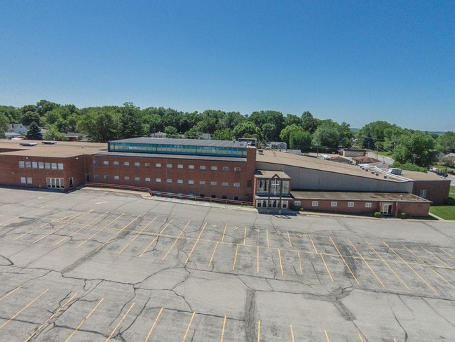

Property Detail
1701 E 33Rd St
060-09374005000
-EX W 33F RD & E 615F W 648F N 205F & E 630F W 663F S 155F N 360F- N 20A S 30A SW 1/4 NE 1/4 SEC 32-79-23
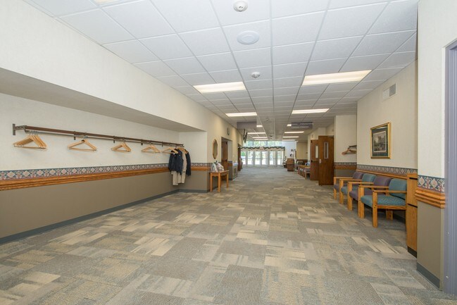
Publicschool
Polk
R1-60
Iowa
B and X Area of moderate flood hazard, usually the area between the limits of the 100-year and 500-year floods.
14.49 AC
0
Northeast
2025
Des Moines
001900
Des Moines-West Des Moines, IA
89,286 SF
NEARBY LISTINGS FOR SALE OR LEASE
-
-
View all Des Moines listings for sale on LoopNet.com
DEMOGRAPHICS near 1701 E 33Rd St
1 mile
3 mile
5 mile
2025 Total Population
9,430
59,717
145,711
2030 Population
9,743
61,946
152,327
Pop Growth 2025-2030
+ 3.32%
+ 3.73%
+ 4.54%
Average Age
39
39
38
2025 Total Households
3,650
22,789
58,477
HH Growth 2025-2030
+ 3.40%
+ 3.87%
+ 4.87%
Median Household Inc
$64,925
$60,277
$61,329
Avg Household Size
2.50
2.50
2.40
2025 Avg HH Vehicles
2.00
2.00
2.00
Median Home Value
$165,492
$178,704
$189,712
Median Year Built
1955
1963
1971
Nearby Places
Map Layers
Map Styles
 Street
 Aerial
Layers
 Traffic
 Biking
Places
Listings with unknown addresses are not visible on the map
- Restaurants
- Banks
- Shops
- Fitness
- Groceries
PUBLIC TRANSPORTATION
AIRPORT
Des Moines International
Drive
Walk
Distance
Des Moines International
22 min
10.5 mi
Freight Ports
Port Milwaukee
Drive
Walk
Distance
Port Milwaukee
412 min
368.5 mi
SALE & LEASE HISTORY
LISTING DATE
SALE/LEASE

Sep 23, 2016
For Sale
Nearby Properties
Address
Land Use
TOTAL SIZE
Lot Size
Zoning
Address
Land Use
TOTAL SIZE
Lot Size
Zoning
481,030 SF
31.92 AC
PUD
Address
Land Use
TOTAL SIZE
Lot Size
Zoning
675,000 SF
65.27 AC
Address
Land Use
TOTAL SIZE
Lot Size
Zoning
177,094 SF
24.60 AC
Address
Land Use
TOTAL SIZE
Lot Size
Zoning
475,929 SF
49.86 AC
M2
Address
Land Use
TOTAL SIZE
Lot Size
Zoning
342,000 SF
22.18 AC
Address
Land Use
TOTAL SIZE
Lot Size
Zoning
312,500 SF
38.14 AC
Address
Land Use
TOTAL SIZE
Lot Size
Zoning
320,429 SF
22.34 AC
R3
Address
Land Use
TOTAL SIZE
Lot Size
Zoning
529,161 SF
33.60 AC
HI
Address
Land Use
TOTAL SIZE
Lot Size
Zoning
603,502 SF
33.03 AC
M-1
Address
Land Use
TOTAL SIZE
Lot Size
Zoning
90,325 SF
5.49 AC
PUD
Address
Land Use
TOTAL SIZE
Lot Size
Zoning
82,202 SF
9.48 AC
PUD
Address
Land Use
TOTAL SIZE
Lot Size
Zoning
218,593 SF
19.31 AC
M-2
Address
Land Use
TOTAL SIZE
Lot Size
Zoning
118,080 SF
15.76 AC
Address
Land Use
TOTAL SIZE
Lot Size
Zoning
175,854 SF
22.81 AC
Address
Land Use
TOTAL SIZE
Lot Size
Zoning
79,991 SF
4.55 AC
M-1
Address
Land Use
TOTAL SIZE
Lot Size
Zoning
1,890,511 SF
39.03 AC
M-2
Address
Land Use
TOTAL SIZE
Lot Size
Zoning
274,160 SF
19.99 AC
M-1
Address
Land Use
TOTAL SIZE
Lot Size
Zoning
155,276 SF
6.66 AC
R-4
Address
Land Use
TOTAL SIZE
Lot Size
Zoning
181,492 SF
12.32 AC
M1
Address
Land Use
TOTAL SIZE
Lot Size
Zoning
201,072 SF
26.81 AC
Address
Land Use
TOTAL SIZE
Lot Size
Zoning
79,823 SF
11.47 AC
M2
Address
Land Use
TOTAL SIZE
Lot Size
Zoning
71,666 SF
18.40 AC
R1-80
Address
Land Use
TOTAL SIZE
Lot Size
Zoning
198,500 SF
11.79 AC
M-1
Address
Land Use
TOTAL SIZE
Lot Size
Zoning
199,180 SF
9.64 AC
M-1
Address
Land Use
TOTAL SIZE
Lot Size
Zoning
83,885 SF
1.57 AC
PUD
Address
Land Use
TOTAL SIZE
Lot Size
Zoning
61,030 SF
3.37 AC
Address
Land Use
TOTAL SIZE
Lot Size
Zoning
126,830 SF
6.53 AC
Address
Land Use
TOTAL SIZE
Lot Size
Zoning
127,200 SF
12.31 AC
HI
Address
Land Use
TOTAL SIZE
Lot Size
Zoning
76,524 SF
3.17 AC
C-2
Address
Land Use
TOTAL SIZE
Lot Size
Zoning
45,004 SF
5.68 AC
The World's #1 Commercial Real Estate Marketplace
Connect with us
© 2026 CoStar Group
The information above has been obtained from sources believed reliable. While we do not doubt its accuracy we have not verified it and make no guarantee, warranty or representation about it. It is your responsibility to independently confirm its accuracy and completeness. Any projections, opinions, assumptions, or estimates used are for example only and do not represent the current or future performance of the property. The value of this transaction to you depends on tax and other factors which should be evaluated by your tax, financial, and legal advisors. You and your advisors should conduct a careful, independent investigation of the property to determine to your satisfaction the suitability of the property for your needs.