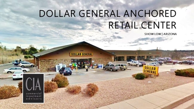
Property Record
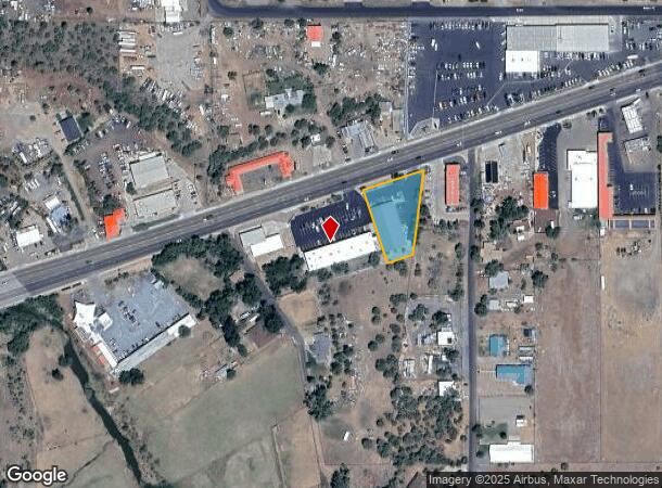
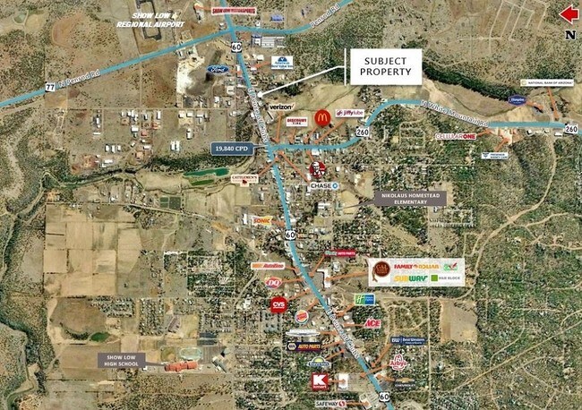
1701 E Deuce Of Clubs, Show Low, AZ 85901

NEARBY LISTINGS FOR SALE OR LEASE
Property Detail
1701 E Deuce Of Clubs
Show Low, AZ
Mary Lee Beck Subdivision
210-24-074D
SECTION 21, T10N, R22E:LOT C OF SURVEY 56-43. AKA: COMM NW COR SEC 21; TH S0*25'18 E 644.73'; TH N71*46'47 E 215.97'; TH N72*15'26E 254.75' TPOB; TH N72*15'26 E 188.35'; TH S06*42'32 W 254.92';TH S73*02'15 W 82.85'; TH N17*42'09 W 76.53'; TH N72*20'2
Storemultistory
Navajo
X
Arizona
04017C4494E
c
2024
0.72 AC
2026
Arizona Northeast & Holbrook Area
961701
Other Market Areas
9,375 SF
DEMOGRAPHICS near 1701 E Deuce Of Clubs
1 Mile
3 Mile
5 Mile
2024 Total Population
1,215
11,711
21,525
2029 Population
1,279
12,668
23,531
Pop Growth 2024-2029
+ 5.27%
+ 8.17%
+ 9.32%
Average Age
41
41
44
2024 Total Households
487
4,667
8,752
HH Growth 2024-2029
+ 5.34%
+ 8.08%
+ 9.31%
Median Household Inc
$63,101
$58,721
$56,582
Avg Household Size
2.40
2.40
2.40
2024 Avg HH Vehicles
2.00
2.00
2.00
Median Home Value
$231,915
$230,584
$234,426
Median Year Built
1986
1997
1998
Nearby Places
Map Layers
Map Styles
 Street
 Aerial
- Restaurants
- Banks
- Shops
- Fitness
- Groceries
Nearby Properties
Address
Land Use
TOTAL SIZE
Lot Size
Zoning
Address
Land Use
TOTAL SIZE
Lot Size
Zoning
147,745 SF
12.70 AC
MUNICIPAL
Address
Land Use
TOTAL SIZE
Lot Size
Zoning
81,647 SF
4.47 AC
MUNICIPAL
Address
Land Use
TOTAL SIZE
Lot Size
Zoning
74,338 SF
2.29 AC
Address
Land Use
TOTAL SIZE
Lot Size
Zoning
56,032 SF
4.60 AC
MUNICIPAL
Address
Land Use
TOTAL SIZE
Lot Size
Zoning
55,237 SF
6.03 AC
MUNICIPAL
Address
Land Use
TOTAL SIZE
Lot Size
Zoning
30,952 SF
5.72 AC
MUNICIPAL
Address
Land Use
TOTAL SIZE
Lot Size
Zoning
89,607 SF
5.78 AC
Address
Land Use
TOTAL SIZE
Lot Size
Zoning
29,707 SF
3 AC
MUNICIPAL
Address
Land Use
TOTAL SIZE
Lot Size
Zoning
32,762 SF
1.95 AC
MUNICIPAL
Address
Land Use
TOTAL SIZE
Lot Size
Zoning
30,942 SF
3.21 AC
MUNICIPAL
Address
Land Use
TOTAL SIZE
Lot Size
Zoning
46,700 SF
2.51 AC
MUNICIPAL
Address
Land Use
TOTAL SIZE
Lot Size
Zoning
33,421 SF
5.84 AC
MUNICIPAL
Address
Land Use
TOTAL SIZE
Lot Size
Zoning
19,280 SF
6.14 AC
MUNICIPAL
Address
Land Use
TOTAL SIZE
Lot Size
Zoning
76,060 SF
4.69 AC
MUNICIPAL
Address
Land Use
TOTAL SIZE
Lot Size
Zoning
8 AC
MUNICIPAL
Address
Land Use
TOTAL SIZE
Lot Size
Zoning
62,331 SF
4.20 AC
MUNICIPAL
Address
Land Use
TOTAL SIZE
Lot Size
Zoning
26,513 SF
9.76 AC
MUNICIPAL
Address
Land Use
TOTAL SIZE
Lot Size
Zoning
89,607 SF
3.97 AC
Address
Land Use
TOTAL SIZE
Lot Size
Zoning
21,291 SF
1.80 AC
MUNICIPAL
Address
Land Use
TOTAL SIZE
Lot Size
Zoning
16,349 SF
3.68 AC
MUNICIPAL
Address
Land Use
TOTAL SIZE
Lot Size
Zoning
24,000 SF
4.09 AC
MUNICIPAL
Address
Land Use
TOTAL SIZE
Lot Size
Zoning
17,948 SF
3.31 AC
MUNICIPAL
Address
Land Use
TOTAL SIZE
Lot Size
Zoning
31,443 SF
1.96 AC
MUNICIPAL
Address
Land Use
TOTAL SIZE
Lot Size
Zoning
24,876 SF
1.89 AC
MUNICIPAL
Address
Land Use
TOTAL SIZE
Lot Size
Zoning
22,705 SF
3.74 AC
MUNICIPAL
Address
Land Use
TOTAL SIZE
Lot Size
Zoning
10,880 SF
1.36 AC
MUNICIPAL
Address
Land Use
TOTAL SIZE
Lot Size
Zoning
19,369 SF
17.26 AC
MUNICIPAL
Address
Land Use
TOTAL SIZE
Lot Size
Zoning
48,000 SF
1.15 AC
MUNICIPAL
Address
Land Use
TOTAL SIZE
Lot Size
Zoning
25,015 SF
1.89 AC
MUNICIPAL
The World's #1 Commercial Real Estate Marketplace
Connect with us
© 2025 CoStar Group
The information above has been obtained from sources believed reliable. While we do not doubt its accuracy we have not verified it and make no guarantee, warranty or representation about it. It is your responsibility to independently confirm its accuracy and completeness. Any projections, opinions, assumptions, or estimates used are for example only and do not represent the current or future performance of the property. The value of this transaction to you depends on tax and other factors which should be evaluated by your tax, financial, and legal advisors. You and your advisors should conduct a careful, independent investigation of the property to determine to your satisfaction the suitability of the property for your needs.