Property Record
1701 E Slaton Rd, Lubbock, TX 79404
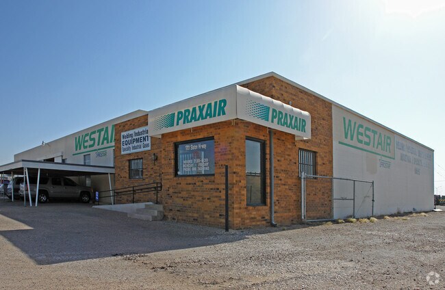


Property Detail
1701 E Slaton Rd
Lubbock, TX
BARTOS S148.16OF L 3 & BLK E SEC 6 AB 491 TR 8A1 & 8G
R28795
LUBBOCK
Commercialnec
Texas
B and X Area of moderate flood hazard, usually the area between the limits of the 100-year and 500-year floods.
35
2024
1.48 AC
2025
Southeast Inner Loop
002500
Lubbock
12,291 SF
NEARBY LISTINGS FOR SALE OR LEASE
DEMOGRAPHICS near 1701 E Slaton Rd
1 mile
3 mile
5 mile
2025 Total Population
928
31,805
114,337
2030 Population
987
33,275
119,073
Pop Growth 2025-2030
+ 6.36%
+ 4.62%
+ 4.14%
Average Age
37
36
35
2025 Total Households
328
11,677
42,241
HH Growth 2025-2030
+ 6.71%
+ 4.86%
+ 4.62%
Median Household Inc
$64,024
$48,722
$52,192
Avg Household Size
2.70
2.60
2.40
2025 Avg HH Vehicles
2.00
2.00
2.00
Median Home Value
$128,682
$129,299
$176,891
Median Year Built
1985
1977
1976
Nearby Places
Map Layers
Map Styles
 Street
 Aerial
Layers
 Traffic
 Biking
Places
Listings with unknown addresses are not visible on the map
- Restaurants
- Banks
- Shops
- Fitness
- Groceries
PUBLIC TRANSPORTATION
AIRPORT
Lubbock Preston Smith International
Drive
Walk
Distance
Lubbock Preston Smith International
26 min
15.7 mi
Nearby Properties
Address
Land Use
TOTAL SIZE
Lot Size
Zoning
Address
Land Use
TOTAL SIZE
Lot Size
Zoning
709,350 SF
98.60 AC
Address
Land Use
TOTAL SIZE
Lot Size
Zoning
176,165 SF
36.61 AC
Address
Land Use
TOTAL SIZE
Lot Size
Zoning
7.68 AC
Address
Land Use
TOTAL SIZE
Lot Size
Zoning
167,208 SF
10.09 AC
Address
Land Use
TOTAL SIZE
Lot Size
Zoning
157,644 SF
9.69 AC
Address
Land Use
TOTAL SIZE
Lot Size
Zoning
76,680 SF
4.95 AC
Address
Land Use
TOTAL SIZE
Lot Size
Zoning
421,200 SF
43.22 AC
Address
Land Use
TOTAL SIZE
Lot Size
Zoning
205,150 SF
23.43 AC
Address
Land Use
TOTAL SIZE
Lot Size
Zoning
150,000 SF
216.67 AC
Address
Land Use
TOTAL SIZE
Lot Size
Zoning
192,128 SF
9.87 AC
Address
Land Use
TOTAL SIZE
Lot Size
Zoning
53,816 SF
1.32 AC
Address
Land Use
TOTAL SIZE
Lot Size
Zoning
42,288 SF
5.30 AC
Address
Land Use
TOTAL SIZE
Lot Size
Zoning
189,737 SF
31 AC
Address
Land Use
TOTAL SIZE
Lot Size
Zoning
88,310 SF
9.95 AC
Address
Land Use
TOTAL SIZE
Lot Size
Zoning
367,283 SF
36.77 AC
Address
Land Use
TOTAL SIZE
Lot Size
Zoning
55,824 SF
2.28 AC
Address
Land Use
TOTAL SIZE
Lot Size
Zoning
62,226 SF
6.90 AC
Address
Land Use
TOTAL SIZE
Lot Size
Zoning
5,000 SF
190 AC
Address
Land Use
TOTAL SIZE
Lot Size
Zoning
69,391 SF
6.47 AC
Address
Land Use
TOTAL SIZE
Lot Size
Zoning
79,488 SF
5.23 AC
Address
Land Use
TOTAL SIZE
Lot Size
Zoning
179,172 SF
11.72 AC
Address
Land Use
TOTAL SIZE
Lot Size
Zoning
233,241 SF
12.52 AC
Address
Land Use
TOTAL SIZE
Lot Size
Zoning
159,054 SF
7.53 AC
Address
Land Use
TOTAL SIZE
Lot Size
Zoning
45,144 SF
2.99 AC
Address
Land Use
TOTAL SIZE
Lot Size
Zoning
27,017 SF
25.54 AC
Address
Land Use
TOTAL SIZE
Lot Size
Zoning
45,421 SF
1.83 AC
Address
Land Use
TOTAL SIZE
Lot Size
Zoning
112,725 SF
20 AC
Address
Land Use
TOTAL SIZE
Lot Size
Zoning
46,034 SF
14.04 AC
Address
Land Use
TOTAL SIZE
Lot Size
Zoning
147,479 SF
7.56 AC
Address
Land Use
TOTAL SIZE
Lot Size
Zoning
163,080 SF
9.32 AC
The World's #1 Commercial Real Estate Marketplace
Connect with us
© 2026 CoStar Group
The information above has been obtained from sources believed reliable. While we do not doubt its accuracy we have not verified it and make no guarantee, warranty or representation about it. It is your responsibility to independently confirm its accuracy and completeness. Any projections, opinions, assumptions, or estimates used are for example only and do not represent the current or future performance of the property. The value of this transaction to you depends on tax and other factors which should be evaluated by your tax, financial, and legal advisors. You and your advisors should conduct a careful, independent investigation of the property to determine to your satisfaction the suitability of the property for your needs.