Property Record
1701 Hempstead Rd, Lancaster, PA 17601

Save to a Folder
{{folder.Name}}
{{folder.ListingIds.length}} Properties
{{folder.ListingIds.length}} Property
Create a New Folder
Property Detail
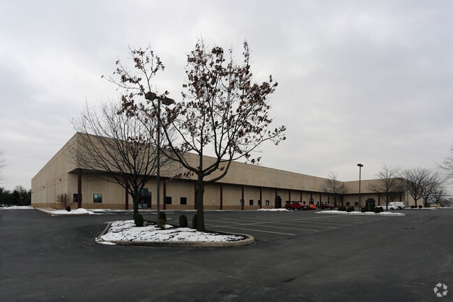
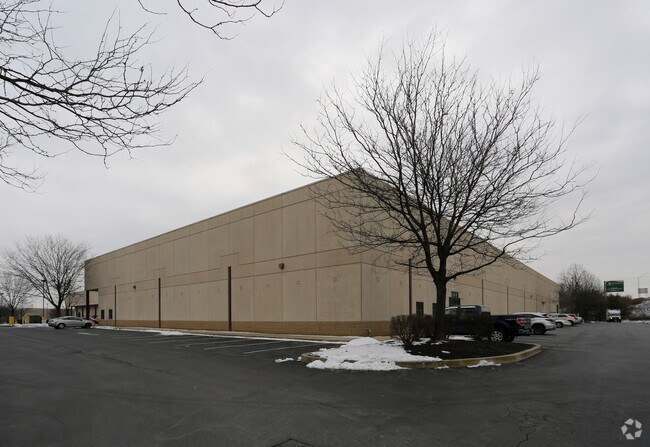
1701 Hempstead Rd
310-54699-0-0000
1701 HEMPSTEAD RD
Lightindustrial
Lancaster
I
Pennsylvania
B and X Area of moderate flood hazard, usually the area between the limits of the 100-year and 500-year floods.
6
2025
8.38 AC
2026
Lancaster County
013203
Philadelphia
123,252 SF
Lancaster, PA
NEARBY LISTINGS FOR SALE OR LEASE
DEMOGRAPHICS near 1701 Hempstead Rd
1 mile
3 mile
5 mile
2025 Total Population
5,737
57,493
147,567
2030 Population
5,814
58,212
149,549
Pop Growth 2025-2030
+ 1.34%
+ 1.25%
+ 1.34%
Average Age
43
40
40
2025 Total Households
2,495
21,271
56,455
HH Growth 2025-2030
+ 1.48%
+ 1.24%
+ 1.33%
Median Household Inc
$77,138
$79,355
$73,766
Avg Household Size
2.30
2.50
2.40
2025 Avg HH Vehicles
2.00
2.00
2.00
Median Home Value
$273,179
$296,144
$294,259
Median Year Built
1987
1967
1964
Nearby Places
Map Layers
Map Styles
 Street
 Aerial
Layers
 Traffic
 Biking
Places
Listings with unknown addresses are not visible on the map
- Restaurants
- Banks
- Shops
- Fitness
- Groceries
PUBLIC TRANSPORTATION
COMMUTER RAIL
Lancaster (Keystone Service - Amtrak, Pennsylvanian - Amtrak)
Drive
Walk
Distance
Lancaster (Keystone Service - Amtrak, Pennsylvanian - Amtrak)
10 min
5.1 mi
AIRPORT
Harrisburg International
Drive
Walk
Distance
Harrisburg International
45 min
34.5 mi
Freight Ports
Port of Wilmington, RI
Drive
Walk
Distance
Port of Wilmington, RI
88 min
50.3 mi
SALE & LEASE HISTORY
LISTING DATE
SALE/LEASE

Feb 27, 2018
For Lease
Nearby Properties
Address
Land Use
TOTAL SIZE
Lot Size
Zoning
Address
Land Use
TOTAL SIZE
Lot Size
Zoning
1,120,221 SF
8.40 AC
Address
Land Use
TOTAL SIZE
Lot Size
Zoning
871,695 SF
69.40 AC
R2
Address
Land Use
TOTAL SIZE
Lot Size
Zoning
315,373 SF
4.73 AC
DF
Address
Land Use
TOTAL SIZE
Lot Size
Zoning
403,771 SF
106.93 AC
Address
Land Use
TOTAL SIZE
Lot Size
Zoning
610,108 SF
39.96 AC
C-2
Address
Land Use
TOTAL SIZE
Lot Size
Zoning
419,136 SF
34.11 AC
Address
Land Use
TOTAL SIZE
Lot Size
Zoning
251,676 SF
40.20 AC
R-2
Address
Land Use
TOTAL SIZE
Lot Size
Zoning
333,301 SF
24.15 AC
MU
Address
Land Use
TOTAL SIZE
Lot Size
Zoning
275,959 SF
68.50 AC
IN
Address
Land Use
TOTAL SIZE
Lot Size
Zoning
322,380 SF
33.29 AC
R-3
Address
Land Use
TOTAL SIZE
Lot Size
Zoning
234,386 SF
15.30 AC
MU
Address
Land Use
TOTAL SIZE
Lot Size
Zoning
289,398 SF
35.20 AC
C-2
Address
Land Use
TOTAL SIZE
Lot Size
Zoning
254,079 SF
21.54 AC
Address
Land Use
TOTAL SIZE
Lot Size
Zoning
219,576 SF
21.41 AC
Address
Land Use
TOTAL SIZE
Lot Size
Zoning
234,681 SF
7.50 AC
MU
Address
Land Use
TOTAL SIZE
Lot Size
Zoning
195,708 SF
26.17 AC
Address
Land Use
TOTAL SIZE
Lot Size
Zoning
233,826 SF
12.73 AC
Address
Land Use
TOTAL SIZE
Lot Size
Zoning
323,300 SF
21.60 AC
C-2
Address
Land Use
TOTAL SIZE
Lot Size
Zoning
125,073 SF
19.07 AC
I
Address
Land Use
TOTAL SIZE
Lot Size
Zoning
302,460 SF
51.80 AC
R4
Address
Land Use
TOTAL SIZE
Lot Size
Zoning
87,502 SF
11.69 AC
MU
Address
Land Use
TOTAL SIZE
Lot Size
Zoning
125,153 SF
24.10 AC
Address
Land Use
TOTAL SIZE
Lot Size
Zoning
123,445 SF
13.66 AC
I
Address
Land Use
TOTAL SIZE
Lot Size
Zoning
198,937 SF
24.74 AC
R-2
Address
Land Use
TOTAL SIZE
Lot Size
Zoning
844,700 SF
59.50 AC
I
Address
Land Use
TOTAL SIZE
Lot Size
Zoning
63,514 SF
177.90 AC
R-1
Address
Land Use
TOTAL SIZE
Lot Size
Zoning
136,104 SF
11.14 AC
Address
Land Use
TOTAL SIZE
Lot Size
Zoning
244,922 SF
18.40 AC
MU
Address
Land Use
TOTAL SIZE
Lot Size
Zoning
164,716 SF
0.47 AC
Address
Land Use
TOTAL SIZE
Lot Size
Zoning
251,051 SF
31.10 AC
R-3
The World's #1 Commercial Real Estate Marketplace
Connect with us
© 2026 CoStar Group
The information above has been obtained from sources believed reliable. While we do not doubt its accuracy we have not verified it and make no guarantee, warranty or representation about it. It is your responsibility to independently confirm its accuracy and completeness. Any projections, opinions, assumptions, or estimates used are for example only and do not represent the current or future performance of the property. The value of this transaction to you depends on tax and other factors which should be evaluated by your tax, financial, and legal advisors. You and your advisors should conduct a careful, independent investigation of the property to determine to your satisfaction the suitability of the property for your needs.