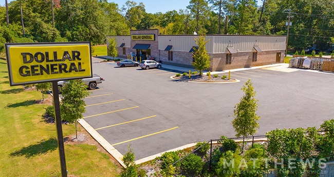
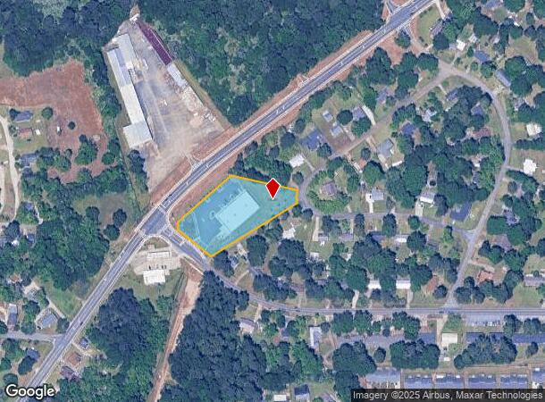
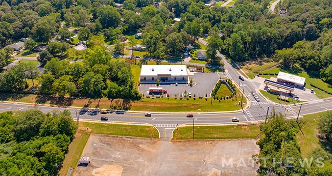
Property Record
1701 Kings Chapel Rd, Perry, GA 31069

NEARBY LISTINGS FOR SALE OR LEASE
-
-
-
-
-
-
No Photo
-
View all Perry listings for sale on LoopNet.com
Property Detail
1701 Kings Chapel Rd
0P0190001000
P-19 Suber Davis S D
Wholesaleoutletdiscountstore
MAYO DAVIS BUSINESS BLOCK LL 82 10TH LD
X
Houston
13153C0154E
Georgia
2024
1.64 AC
2024
Perry/Warner Robins
021401
Other Market Areas
11,197 SF
Warner Robins, GA
DEMOGRAPHICS near 1701 Kings Chapel Rd
1 Mile
3 Mile
5 Mile
2024 Total Population
6,701
19,276
32,477
2029 Population
7,395
21,307
35,937
Pop Growth 2024-2029
+ 10.36%
+ 10.54%
+ 10.65%
Average Age
38
39
38
2024 Total Households
2,616
7,412
12,102
HH Growth 2024-2029
+ 10.09%
+ 10.38%
+ 10.47%
Median Household Inc
$54,213
$65,634
$75,789
Avg Household Size
2.30
2.50
2.60
2024 Avg HH Vehicles
2.00
2.00
2.00
Median Home Value
$164,067
$178,397
$183,145
Median Year Built
1986
1991
1999
Nearby Places
Map Layers
Map Styles
 Street
 Aerial
- Restaurants
- Banks
- Shops
- Fitness
- Groceries
SALE & LEASE HISTORY
LISTING DATE
SALE/LEASE

Oct 10, 2024
For Sale
Nearby Properties
Address
Land Use
TOTAL SIZE
Lot Size
Zoning
Address
Land Use
TOTAL SIZE
Lot Size
Zoning
68,186 SF
562.30 AC
GU
Address
Land Use
TOTAL SIZE
Lot Size
Zoning
147,496 SF
66.05 AC
GU
Address
Land Use
TOTAL SIZE
Lot Size
Zoning
158,407 SF
218.84 AC
M2
Address
Land Use
TOTAL SIZE
Lot Size
Zoning
262,500 SF
20 AC
GU
Address
Land Use
TOTAL SIZE
Lot Size
Zoning
0.44 AC
Address
Land Use
TOTAL SIZE
Lot Size
Zoning
158,300 SF
30 AC
GU
Address
Land Use
TOTAL SIZE
Lot Size
Zoning
49,947 SF
4.03 AC
C2
Address
Land Use
TOTAL SIZE
Lot Size
Zoning
439.32 AC
M2
Address
Land Use
TOTAL SIZE
Lot Size
Zoning
439.32 AC
M2
Address
Land Use
TOTAL SIZE
Lot Size
Zoning
78,010 SF
20 AC
C2
Address
Land Use
TOTAL SIZE
Lot Size
Zoning
6,382 SF
24.71 AC
RM-2
Address
Land Use
TOTAL SIZE
Lot Size
Zoning
5,736 SF
16.65 AC
RM-2
Address
Land Use
TOTAL SIZE
Lot Size
Zoning
91,249 SF
15.85 AC
GU
Address
Land Use
TOTAL SIZE
Lot Size
Zoning
304,196 SF
177.46 AC
M1
Address
Land Use
TOTAL SIZE
Lot Size
Zoning
25,002 SF
15.17 AC
RM-2
Address
Land Use
TOTAL SIZE
Lot Size
Zoning
442.42 AC
M2
Address
Land Use
TOTAL SIZE
Lot Size
Zoning
151,525 SF
17.55 AC
C2
Address
Land Use
TOTAL SIZE
Lot Size
Zoning
106,055 SF
22.72 AC
GU
Address
Land Use
TOTAL SIZE
Lot Size
Zoning
46,200 SF
12.29 AC
C2
Address
Land Use
TOTAL SIZE
Lot Size
Zoning
19,810 SF
79.64 AC
GU
Address
Land Use
TOTAL SIZE
Lot Size
Zoning
31,248 SF
10.30 AC
RM-2
Address
Land Use
TOTAL SIZE
Lot Size
Zoning
255.39 AC
GU/M1
Address
Land Use
TOTAL SIZE
Lot Size
Zoning
54,262 SF
38.29 AC
M1
Address
Land Use
TOTAL SIZE
Lot Size
Zoning
4,820 SF
14.59 AC
RM-2
Address
Land Use
TOTAL SIZE
Lot Size
Zoning
12,000 SF
7.27 AC
RM-2
Address
Land Use
TOTAL SIZE
Lot Size
Zoning
226.03 AC
GU
Address
Land Use
TOTAL SIZE
Lot Size
Zoning
30,050 SF
47.52 AC
GU
Address
Land Use
TOTAL SIZE
Lot Size
Zoning
38,066 SF
11.73 AC
GU
Address
Land Use
TOTAL SIZE
Lot Size
Zoning
44,832 SF
11.95 AC
GU
Address
Land Use
TOTAL SIZE
Lot Size
Zoning
218.84 AC
M2
The World's #1 Commercial Real Estate Marketplace
Connect with us
© 2025 CoStar Group
The information above has been obtained from sources believed reliable. While we do not doubt its accuracy we have not verified it and make no guarantee, warranty or representation about it. It is your responsibility to independently confirm its accuracy and completeness. Any projections, opinions, assumptions, or estimates used are for example only and do not represent the current or future performance of the property. The value of this transaction to you depends on tax and other factors which should be evaluated by your tax, financial, and legal advisors. You and your advisors should conduct a careful, independent investigation of the property to determine to your satisfaction the suitability of the property for your needs.