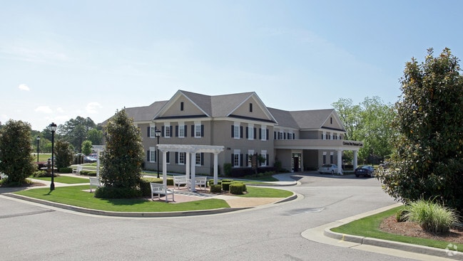
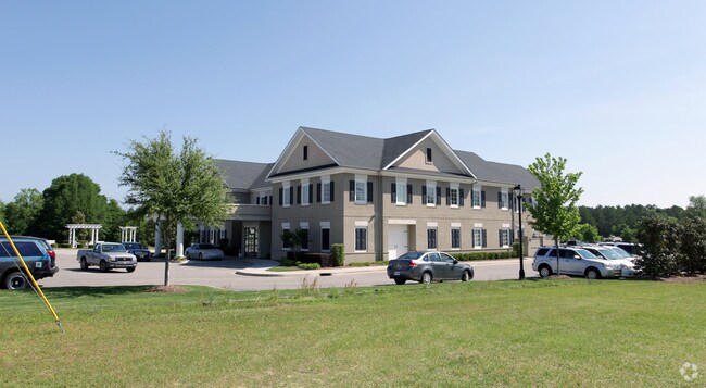
Property Record
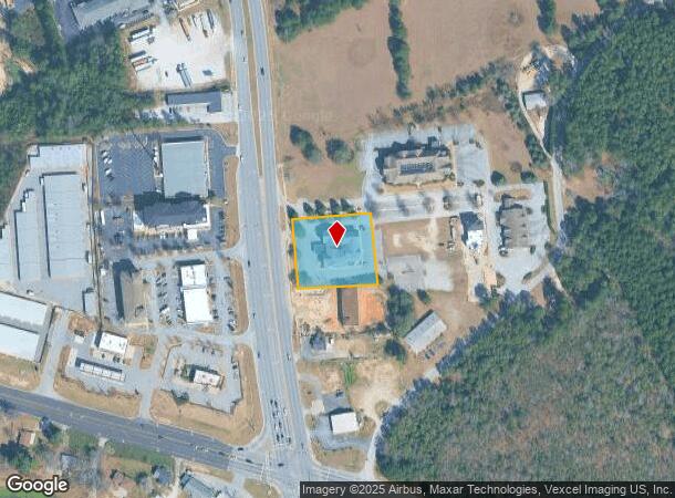
1701 Magnolia Way, Augusta, GA 30909
NEARBY LISTINGS FOR SALE OR LEASE
Property Detail
1701 Magnolia Way
Augusta-Richmond County, GA-SC
Village At Crossroads
074-113I
LOT 1 1.12 ACS; VILLAGE AT CROSSROADS
Officebuilding
Columbia
X
Georgia
13245C0085G
1
2025
1.12 AC
2025
Outlying Columbia County
030505
Augusta/Richmond County
19,032 SF
DEMOGRAPHICS near 1701 Magnolia Way
1 Mile
3 Mile
5 Mile
2024 Total Population
3,737
46,941
122,403
2029 Population
3,999
49,428
129,773
Pop Growth 2024-2029
+ 7.01%
+ 5.30%
+ 6.02%
Average Age
39
39
38
2024 Total Households
1,583
18,845
47,820
HH Growth 2024-2029
+ 6.25%
+ 4.53%
+ 5.24%
Median Household Inc
$60,305
$63,552
$66,229
Avg Household Size
2.30
2.40
2.40
2024 Avg HH Vehicles
2.00
2.00
2.00
Median Home Value
$133,301
$171,673
$192,037
Median Year Built
1990
1993
1990
Nearby Places
Map Layers
Map Styles
 Street
 Aerial
- Restaurants
- Banks
- Shops
- Fitness
- Groceries
PUBLIC TRANSPORTATION
AIRPORT
Augusta Regional at Bush Field
DRIVE
WALK
Distance
Augusta Regional at Bush Field
25 min
13.9 mi
Freight Ports
Georgia Ports - Savannah
DRIVE
WALK
Distance
Georgia Ports - Savannah
159 min
123.0 mi
Nearby Properties
Address
Land Use
TOTAL SIZE
Lot Size
Zoning
Address
Land Use
TOTAL SIZE
Lot Size
Zoning
371,617 SF
13.26 AC
B-2
Address
Land Use
TOTAL SIZE
Lot Size
Zoning
4,357 SF
34 AC
R-3B
Address
Land Use
TOTAL SIZE
Lot Size
Zoning
292,232 SF
39.73 AC
B-2
Address
Land Use
TOTAL SIZE
Lot Size
Zoning
5,541 SF
14.81 AC
B-2
Address
Land Use
TOTAL SIZE
Lot Size
Zoning
4,077 SF
20.88 AC
C-2;GEN CO
Address
Land Use
TOTAL SIZE
Lot Size
Zoning
5,480 SF
19.05 AC
R-3B
Address
Land Use
TOTAL SIZE
Lot Size
Zoning
984 SF
16.18 AC
R-3C
Address
Land Use
TOTAL SIZE
Lot Size
Zoning
3,680 SF
13.42 AC
B-2
Address
Land Use
TOTAL SIZE
Lot Size
Zoning
92,482 SF
14.77 AC
Address
Land Use
TOTAL SIZE
Lot Size
Zoning
3,498 SF
12.61 AC
B-2
Address
Land Use
TOTAL SIZE
Lot Size
Zoning
2,665 SF
11.80 AC
B-2
Address
Land Use
TOTAL SIZE
Lot Size
Zoning
36,755 SF
12.09 AC
B-2
Address
Land Use
TOTAL SIZE
Lot Size
Zoning
61,236 SF
8.09 AC
R-3B
Address
Land Use
TOTAL SIZE
Lot Size
Zoning
952 SF
29 AC
A
Address
Land Use
TOTAL SIZE
Lot Size
Zoning
3,829 SF
35.30 AC
R-3B
Address
Land Use
TOTAL SIZE
Lot Size
Zoning
4,108 SF
14.12 AC
B-2
Address
Land Use
TOTAL SIZE
Lot Size
Zoning
640 SF
12.17 AC
B-1
Address
Land Use
TOTAL SIZE
Lot Size
Zoning
112,947 SF
14.91 AC
Address
Land Use
TOTAL SIZE
Lot Size
Zoning
72,381 SF
0.95 AC
Address
Land Use
TOTAL SIZE
Lot Size
Zoning
62,440 SF
5.70 AC
B-2
Address
Land Use
TOTAL SIZE
Lot Size
Zoning
11,584 SF
10.34 AC
R-3B
Address
Land Use
TOTAL SIZE
Lot Size
Zoning
156,372 SF
17.81 AC
B-2
Address
Land Use
TOTAL SIZE
Lot Size
Zoning
106,072 SF
9.35 AC
007
Address
Land Use
TOTAL SIZE
Lot Size
Zoning
226,626 SF
34.18 AC
B-2_A
Address
Land Use
TOTAL SIZE
Lot Size
Zoning
2,725 SF
12.42 AC
B-2
Address
Land Use
TOTAL SIZE
Lot Size
Zoning
89,307 SF
3.62 AC
B-2 COND
Address
Land Use
TOTAL SIZE
Lot Size
Zoning
226,626 SF
34.18 AC
B-2_A
Address
Land Use
TOTAL SIZE
Lot Size
Zoning
49,100 SF
22.92 AC
B-2
Address
Land Use
TOTAL SIZE
Lot Size
Zoning
75,000 SF
12.90 AC
Address
Land Use
TOTAL SIZE
Lot Size
Zoning
6,580 SF
50.62 AC
The World's #1 Commercial Real Estate Marketplace
Connect with us
© 2025 CoStar Group
The information above has been obtained from sources believed reliable. While we do not doubt its accuracy we have not verified it and make no guarantee, warranty or representation about it. It is your responsibility to independently confirm its accuracy and completeness. Any projections, opinions, assumptions, or estimates used are for example only and do not represent the current or future performance of the property. The value of this transaction to you depends on tax and other factors which should be evaluated by your tax, financial, and legal advisors. You and your advisors should conduct a careful, independent investigation of the property to determine to your satisfaction the suitability of the property for your needs.