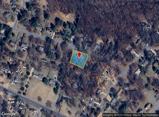
Property Record
1701 Maydale Dr, Silver Spring, MD 20905
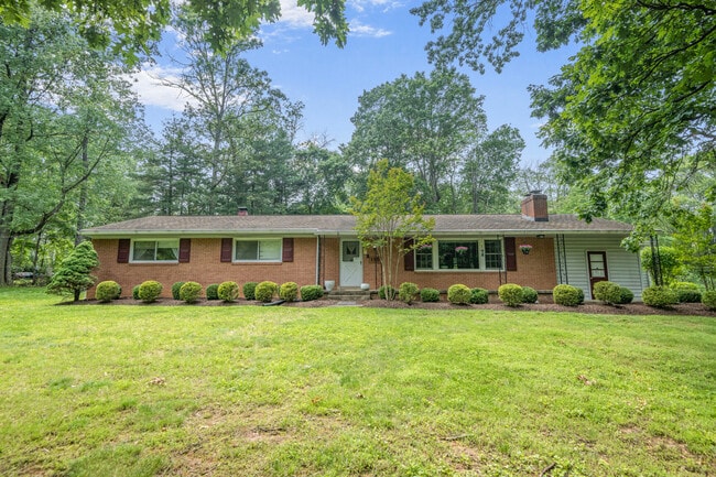
This Property Is For Sale
NEARBY LISTINGS FOR SALE OR LEASE
-
-
View all Silver Spring listings for sale on LoopNet.com
Property Detail
1701 Maydale Dr
Washington-Arlington-Alexandria, DC-VA-MD-WV
Maydale
05-00266951
MAYDALE
Sfr
Montgomery
X
Maryland
24033C0030E
10
2024
0.72 AC
2025
North Silver Spring/Rt 29
701408
Washington, DC
2,732 SF
DEMOGRAPHICS near 1701 Maydale Dr
1 mile
3 mile
5 mile
2024 Total Population
7,267
67,496
174,484
2029 Population
7,168
67,219
173,472
Pop Growth 2024-2029
(1.36%)
(0.41%)
(0.58%)
Average Age
43
41
42
2024 Total Households
2,315
22,410
60,230
HH Growth 2024-2029
(1.60%)
(0.50%)
(0.68%)
Median Household Inc
$144,721
$115,139
$112,904
Avg Household Size
3.10
2.90
2.80
2024 Avg HH Vehicles
3.00
2.00
2.00
Median Home Value
$689,272
$628,724
$594,717
Median Year Built
1977
1982
1981
Nearby Places
Map Layers
Map Styles
 Street
 Aerial
Transit
 Traffic
 Biking
Places
Listings with unknown addresses are not visible on the map
- Restaurants
- Banks
- Shops
- Fitness
- Groceries
PUBLIC TRANSPORTATION
COMMUTER RAIL
Muirkirk (Camden Line - Maryland Area Regional Commuter Trains (The MARC))
Drive
Walk
Distance
Muirkirk (Camden Line - Maryland Area Regional Commuter Trains (The MARC))
13 min
6.7 mi
Greenbelt (Camden Line - Maryland Area Regional Commuter Trains (The MARC))
Drive
Walk
Distance
Greenbelt (Camden Line - Maryland Area Regional Commuter Trains (The MARC))
18 min
9.4 mi
AIRPORT
Ronald Reagan Washington Ntl
Drive
Walk
Distance
Ronald Reagan Washington Ntl
44 min
22.3 mi
Baltimore/Washington International Thurgood Marshall
Drive
Walk
Distance
Baltimore/Washington International Thurgood Marshall
36 min
25.7 mi
Washington Dulles International
Drive
Walk
Distance
Washington Dulles International
59 min
37.6 mi
Freight Ports
Port of Baltimore
Drive
Walk
Distance
Port of Baltimore
40 min
28.3 mi
Nearby Properties
Address
Land Use
TOTAL SIZE
Lot Size
Zoning
Address
Land Use
TOTAL SIZE
Lot Size
Zoning
531,312 SF
25.70 AC
R30
Address
Land Use
TOTAL SIZE
Lot Size
Zoning
385,000 SF
16.42 AC
RH
Address
Land Use
TOTAL SIZE
Lot Size
Zoning
482,799 SF
17.79 AC
R30
Address
Land Use
TOTAL SIZE
Lot Size
Zoning
251,862 SF
91.09 AC
RE2C
Address
Land Use
TOTAL SIZE
Lot Size
Zoning
166,410 SF
26.25 AC
CRT1.
Address
Land Use
TOTAL SIZE
Lot Size
Zoning
310,052 SF
9.63 AC
R20
Address
Land Use
TOTAL SIZE
Lot Size
Zoning
371,939 SF
21.54 AC
EOF1.
Address
Land Use
TOTAL SIZE
Lot Size
Zoning
564,644 SF
16.85 AC
RH
Address
Land Use
TOTAL SIZE
Lot Size
Zoning
222,345 SF
14.21 AC
R30
Address
Land Use
TOTAL SIZE
Lot Size
Zoning
235,616 SF
12.81 AC
R30
Address
Land Use
TOTAL SIZE
Lot Size
Zoning
4,380 SF
17.89 AC
CRT22
Address
Land Use
TOTAL SIZE
Lot Size
Zoning
350,684 SF
36.50 AC
EOF1.
Address
Land Use
TOTAL SIZE
Lot Size
Zoning
456,896 SF
8.96 AC
R20
Address
Land Use
TOTAL SIZE
Lot Size
Zoning
239,072 SF
10.41 AC
R20
Address
Land Use
TOTAL SIZE
Lot Size
Zoning
177,712 SF
13.89 AC
GR1.5
Address
Land Use
TOTAL SIZE
Lot Size
Zoning
154,775 SF
33.38 AC
R200
Address
Land Use
TOTAL SIZE
Lot Size
Zoning
195,369 SF
9.72 AC
R20
Address
Land Use
TOTAL SIZE
Lot Size
Zoning
143,000 SF
20.01 AC
RC
Address
Land Use
TOTAL SIZE
Lot Size
Zoning
202,191 SF
7.70 AC
R30
Address
Land Use
TOTAL SIZE
Lot Size
Zoning
99,491 SF
5.97 AC
R200
Address
Land Use
TOTAL SIZE
Lot Size
Zoning
242,468 SF
17.77 AC
R30
Address
Land Use
TOTAL SIZE
Lot Size
Zoning
115,000 SF
10.14 AC
RE1
Address
Land Use
TOTAL SIZE
Lot Size
Zoning
141,492 SF
7.96 AC
R20
Address
Land Use
TOTAL SIZE
Lot Size
Zoning
7.61 AC
RH
Address
Land Use
TOTAL SIZE
Lot Size
Zoning
127,803 SF
2.91 AC
EOF07
Address
Land Use
TOTAL SIZE
Lot Size
Zoning
94,545 SF
30.85 AC
RC
Address
Land Use
TOTAL SIZE
Lot Size
Zoning
93,796 SF
6.80 AC
NR0.7
Address
Land Use
TOTAL SIZE
Lot Size
Zoning
57,749 SF
4.98 AC
GR1.5
Address
Land Use
TOTAL SIZE
Lot Size
Zoning
130,577 SF
4.45 AC
R200
Address
Land Use
TOTAL SIZE
Lot Size
Zoning
92,227 SF
6.51 AC
R200
The World's #1 Commercial Real Estate Marketplace
Connect with us
© 2026 CoStar Group
The information above has been obtained from sources believed reliable. While we do not doubt its accuracy we have not verified it and make no guarantee, warranty or representation about it. It is your responsibility to independently confirm its accuracy and completeness. Any projections, opinions, assumptions, or estimates used are for example only and do not represent the current or future performance of the property. The value of this transaction to you depends on tax and other factors which should be evaluated by your tax, financial, and legal advisors. You and your advisors should conduct a careful, independent investigation of the property to determine to your satisfaction the suitability of the property for your needs.