Property Record
1701 S 1St St, Yakima, WA 98901
NEARBY LISTINGS FOR SALE OR LEASE
Property Detail
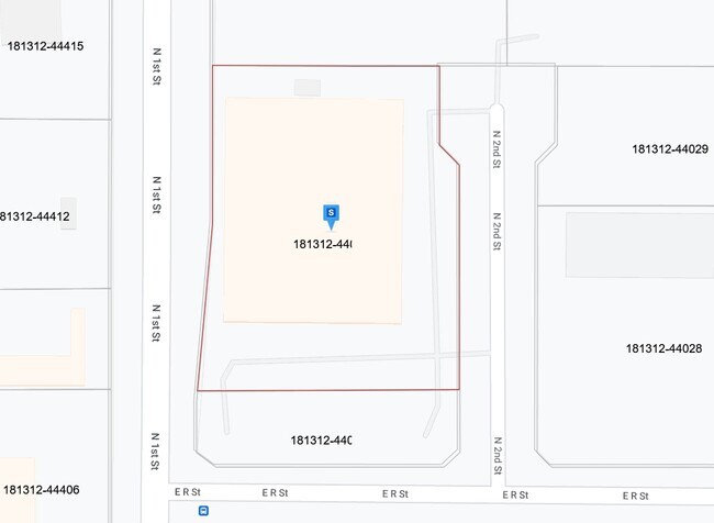
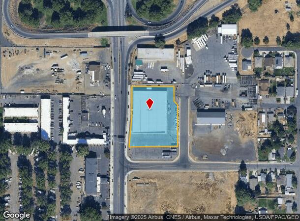
1701 S 1St St
181312-44012
SECTION 12 TOWNSHIP 13 RANGE 18 QUARTER SE BEG SE COR SE 1/4, TH N 0^06'17E 931.6 FT, TH N 89^53'43W 358.37 FT TO TRUE POB, TH N 89^53'43W 232.11 FT, TH S O^04'23E 116.87 FT, TH S 05^09'10W SECTION 12 TOWNSHIP 13 RANGE 18 QUARTER SE LOT 1 OF A SURVEY
Storebuilding
Yakima
X
Washington
53077C1032D
1
2025
1.90 AC
2025
Greater Yakima
001502
Yakima
37,625 SF
Yakima, WA
DEMOGRAPHICS near 1701 S 1St St
1 Mile
3 Mile
5 Mile
2024 Total Population
4,952
63,228
120,762
2029 Population
4,971
63,539
121,512
Pop Growth 2024-2029
+ 0.38%
+ 0.49%
+ 0.62%
Average Age
32
36
37
2024 Total Households
1,495
22,652
43,982
HH Growth 2024-2029
+ 0.20%
+ 0.53%
+ 0.62%
Median Household Inc
$32,665
$48,171
$56,931
Avg Household Size
2.90
2.60
2.60
2024 Avg HH Vehicles
2.00
2.00
2.00
Median Home Value
$78,571
$226,115
$258,995
Median Year Built
1969
1965
1972
Nearby Places
Map Layers
Map Styles
 Street
 Aerial
- Restaurants
- Banks
- Shops
- Fitness
- Groceries
PUBLIC TRANSPORTATION
AIRPORT
Yakima Air Trml/McAllister Field
DRIVE
WALK
Distance
Yakima Air Trml/McAllister Field
13 min
5.3 mi
Freight Ports
Port of Tacoma
DRIVE
WALK
Distance
Port of Tacoma
179 min
153.3 mi
Nearby Properties
Address
Land Use
TOTAL SIZE
Lot Size
Zoning
Address
Land Use
TOTAL SIZE
Lot Size
Zoning
390,527 SF
11.86 AC
R3
Address
Land Use
TOTAL SIZE
Lot Size
Zoning
409,453 SF
8.25 AC
R3
Address
Land Use
TOTAL SIZE
Lot Size
Zoning
197,341 SF
36.70 AC
GC
Address
Land Use
TOTAL SIZE
Lot Size
Zoning
326,323 SF
30.05 AC
R2
Address
Land Use
TOTAL SIZE
Lot Size
Zoning
499,230 SF
22.57 AC
M1
Address
Land Use
TOTAL SIZE
Lot Size
Zoning
193,955 SF
9.94 AC
C1
Address
Land Use
TOTAL SIZE
Lot Size
Zoning
474,587 SF
18.06 AC
M1
Address
Land Use
TOTAL SIZE
Lot Size
Zoning
132,582 SF
32.50 AC
R1
Address
Land Use
TOTAL SIZE
Lot Size
Zoning
87,068 SF
2.89 AC
CBD
Address
Land Use
TOTAL SIZE
Lot Size
Zoning
176,098 SF
1.67 AC
CBD
Address
Land Use
TOTAL SIZE
Lot Size
Zoning
235,222 SF
14.23 AC
M1
Address
Land Use
TOTAL SIZE
Lot Size
Zoning
106,878 SF
3.46 AC
RD
Address
Land Use
TOTAL SIZE
Lot Size
Zoning
298,360 SF
15.21 AC
M1
Address
Land Use
TOTAL SIZE
Lot Size
Zoning
329,388 SF
16.13 AC
M1
Address
Land Use
TOTAL SIZE
Lot Size
Zoning
501,270 SF
21.09 AC
M1
Address
Land Use
TOTAL SIZE
Lot Size
Zoning
82,436 SF
11 AC
RD
Address
Land Use
TOTAL SIZE
Lot Size
Zoning
126,988 SF
9.65 AC
R2
Address
Land Use
TOTAL SIZE
Lot Size
Zoning
153,010 SF
26.44 AC
R1
Address
Land Use
TOTAL SIZE
Lot Size
Zoning
65,606 SF
3.39 AC
R2
Address
Land Use
TOTAL SIZE
Lot Size
Zoning
100,992 SF
9.15 AC
RD
Address
Land Use
TOTAL SIZE
Lot Size
Zoning
79,293 SF
14.01 AC
R1
Address
Land Use
TOTAL SIZE
Lot Size
Zoning
91,856 SF
9.17 AC
RD
Address
Land Use
TOTAL SIZE
Lot Size
Zoning
124,505 SF
13.59 AC
R1
Address
Land Use
TOTAL SIZE
Lot Size
Zoning
56,505 SF
2.75 AC
C1
Address
Land Use
TOTAL SIZE
Lot Size
Zoning
98,397 SF
17.48 AC
R1
Address
Land Use
TOTAL SIZE
Lot Size
Zoning
327,890 SF
18.44 AC
M1
Address
Land Use
TOTAL SIZE
Lot Size
Zoning
197,263 SF
18.08 AC
C1
Address
Land Use
TOTAL SIZE
Lot Size
Zoning
128,789 SF
6.65 AC
R3
Address
Land Use
TOTAL SIZE
Lot Size
Zoning
162,933 SF
14.96 AC
SCC
Address
Land Use
TOTAL SIZE
Lot Size
Zoning
99,000 SF
5.44 AC
C1
The World's #1 Commercial Real Estate Marketplace
Connect with us
© 2026 CoStar Group
The information above has been obtained from sources believed reliable. While we do not doubt its accuracy we have not verified it and make no guarantee, warranty or representation about it. It is your responsibility to independently confirm its accuracy and completeness. Any projections, opinions, assumptions, or estimates used are for example only and do not represent the current or future performance of the property. The value of this transaction to you depends on tax and other factors which should be evaluated by your tax, financial, and legal advisors. You and your advisors should conduct a careful, independent investigation of the property to determine to your satisfaction the suitability of the property for your needs.