Property Record
1701 Tierra Del Norte Loop, Rio Rancho, NM 87144


Property Detail
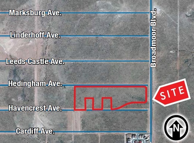
1701 Tierra Del Norte Loop
Albuquerque, NM
LEGAL: S: 12 T: 12N R: 2E SUBD: RIO RANCHO ESTATES BLOCK: 46 UNIT: 13 TRACT: A
1-012-071-379-280
SANDOVAL
Vacantlandnec
New Mexico
B and X Area of moderate flood hazard, usually the area between the limits of the 100-year and 500-year floods.
11.09 AC
2024
Rio Rancho
2025
Albuquerque
010718
NEARBY LISTINGS FOR SALE OR LEASE
DEMOGRAPHICS near 1701 Tierra Del Norte Loop
1 mile
3 mile
5 mile
2025 Total Population
3,458
46,108
105,328
2030 Population
3,853
48,215
109,704
Pop Growth 2025-2030
+ 11.42%
+ 4.57%
+ 4.15%
Average Age
36
40
41
2025 Total Households
1,168
17,217
39,088
HH Growth 2025-2030
+ 11.47%
+ 4.59%
+ 4.21%
Median Household Inc
$94,212
$80,739
$85,155
Avg Household Size
3.00
2.60
2.60
2025 Avg HH Vehicles
2.00
2.00
2.00
Median Home Value
$355,813
$294,296
$321,026
Median Year Built
2010
1995
1997
Nearby Places
Map Layers
Map Styles
 Street
 Aerial
Layers
 Traffic
 Biking
Places
Listings with unknown addresses are not visible on the map
- Restaurants
- Banks
- Shops
- Fitness
- Groceries
PUBLIC TRANSPORTATION
AIRPORT
Albuquerque International Sunport
Drive
Walk
Distance
Albuquerque International Sunport
53 min
24.1 mi
Freight Ports
Tulsa Port Of Catoosa
Drive
Walk
Distance
Tulsa Port Of Catoosa
717 min
675.4 mi
SALE & LEASE HISTORY
LISTING DATE
SALE/LEASE

Sep 24, 2016
For Sale
Nearby Properties
Address
Land Use
TOTAL SIZE
Lot Size
Zoning
Address
Land Use
TOTAL SIZE
Lot Size
Zoning
229,063 SF
18.42 AC
Address
Land Use
TOTAL SIZE
Lot Size
Zoning
416,000 SF
136.40 AC
Address
Land Use
TOTAL SIZE
Lot Size
Zoning
381,500 SF
111.32 AC
Address
Land Use
TOTAL SIZE
Lot Size
Zoning
218,043 SF
2.74 AC
Address
Land Use
TOTAL SIZE
Lot Size
Zoning
256,916 SF
12.06 AC
Address
Land Use
TOTAL SIZE
Lot Size
Zoning
172,213 SF
17.70 AC
Address
Land Use
TOTAL SIZE
Lot Size
Zoning
228,746 SF
66.75 AC
Address
Land Use
TOTAL SIZE
Lot Size
Zoning
66,000 SF
85.14 AC
Address
Land Use
TOTAL SIZE
Lot Size
Zoning
307,481 SF
17.50 AC
Address
Land Use
TOTAL SIZE
Lot Size
Zoning
137,071 SF
8.30 AC
Address
Land Use
TOTAL SIZE
Lot Size
Zoning
62,881 SF
4.67 AC
Address
Land Use
TOTAL SIZE
Lot Size
Zoning
46,000 SF
36.67 AC
Address
Land Use
TOTAL SIZE
Lot Size
Zoning
68,000 SF
6.19 AC
Address
Land Use
TOTAL SIZE
Lot Size
Zoning
124,106 SF
30.54 AC
Address
Land Use
TOTAL SIZE
Lot Size
Zoning
68,123 SF
6.81 AC
Address
Land Use
TOTAL SIZE
Lot Size
Zoning
143,736 SF
9.91 AC
Address
Land Use
TOTAL SIZE
Lot Size
Zoning
85,513 SF
20.30 AC
Address
Land Use
TOTAL SIZE
Lot Size
Zoning
73,234 SF
16.50 AC
Address
Land Use
TOTAL SIZE
Lot Size
Zoning
65,668 SF
3.03 AC
Address
Land Use
TOTAL SIZE
Lot Size
Zoning
64,749 SF
6.21 AC
Address
Land Use
TOTAL SIZE
Lot Size
Zoning
117,926 SF
3 AC
Address
Land Use
TOTAL SIZE
Lot Size
Zoning
143,738 SF
10 AC
Address
Land Use
TOTAL SIZE
Lot Size
Zoning
141,350 SF
14.01 AC
Address
Land Use
TOTAL SIZE
Lot Size
Zoning
121,674 SF
9.63 AC
Address
Land Use
TOTAL SIZE
Lot Size
Zoning
40,000 SF
8.59 AC
Address
Land Use
TOTAL SIZE
Lot Size
Zoning
112,319 SF
21.03 AC
Address
Land Use
TOTAL SIZE
Lot Size
Zoning
Address
Land Use
TOTAL SIZE
Lot Size
Zoning
63,920 SF
15.73 AC
Address
Land Use
TOTAL SIZE
Lot Size
Zoning
27,968 SF
5.17 AC
The World's #1 Commercial Real Estate Marketplace
Connect with us
© 2026 CoStar Group
The information above has been obtained from sources believed reliable. While we do not doubt its accuracy we have not verified it and make no guarantee, warranty or representation about it. It is your responsibility to independently confirm its accuracy and completeness. Any projections, opinions, assumptions, or estimates used are for example only and do not represent the current or future performance of the property. The value of this transaction to you depends on tax and other factors which should be evaluated by your tax, financial, and legal advisors. You and your advisors should conduct a careful, independent investigation of the property to determine to your satisfaction the suitability of the property for your needs.