Property Record
1701 W I65 Service Rd N, Mobile, AL 36618

Save to a Folder
{{folder.Name}}
{{folder.ListingIds.length}} Properties
{{folder.ListingIds.length}} Property
Create a New Folder
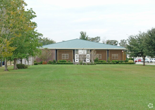
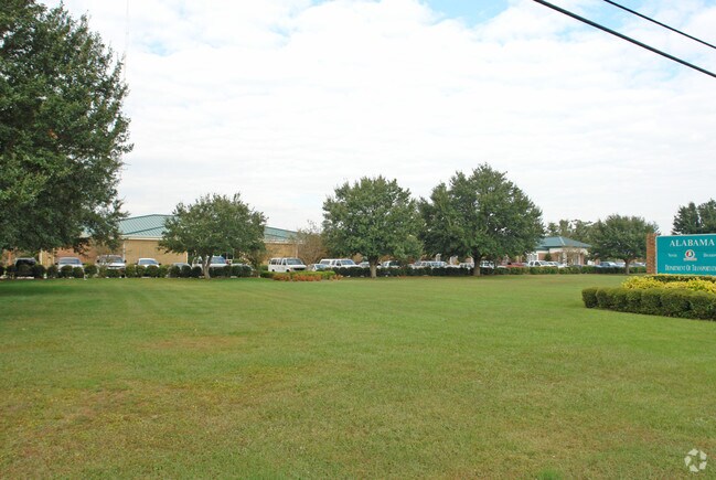
Property Detail
1701 W I65 Service Rd N
Mobile, AL
BEG SE COR LOT 1 BROOKDALE INDUSTRIAL PARK UNIT 1 MBK 23 P 55 SWLY 681 FT W 853 FT N 680 FT E 899.17 FT TO PT OF BEG #SEC 6
29-03-06-3-000-149
Mobile
Officebuilding
Alabama
AE The base floodplain where base flood elevations are provided. AE Zones are now used on new format FIRMs instead of A1-A30 Zones.
1
0
14 AC
2025
West Mobile
003402
Mobile
40,755 SF
NEARBY LISTINGS FOR SALE OR LEASE
DEMOGRAPHICS near 1701 W I65 Service Rd N
1 mile
3 mile
5 mile
2025 Total Population
2,744
51,686
129,961
2030 Population
2,776
52,324
130,554
Pop Growth 2025-2030
+ 1.17%
+ 1.23%
+ 0.46%
Average Age
41
41
39
2025 Total Households
1,024
20,456
52,528
HH Growth 2025-2030
+ 1.17%
+ 1.30%
+ 0.43%
Median Household Inc
$33,987
$41,886
$45,712
Avg Household Size
2.40
2.40
2.30
2025 Avg HH Vehicles
2.00
2.00
2.00
Median Home Value
$73,665
$103,255
$145,473
Median Year Built
1967
1967
1968
Nearby Places
Map Layers
Map Styles
 Street
 Aerial
Layers
 Traffic
 Biking
Places
Listings with unknown addresses are not visible on the map
- Restaurants
- Banks
- Shops
- Fitness
- Groceries
PUBLIC TRANSPORTATION
AIRPORT
Mobile International
Drive
Walk
Distance
Mobile International
16 min
10.6 mi
Mobile Regional
Drive
Walk
Distance
Mobile Regional
24 min
11.8 mi
Freight Ports
Port of Mobile
Drive
Walk
Distance
Port of Mobile
13 min
8.4 mi
Nearby Properties
Address
Land Use
TOTAL SIZE
Lot Size
Zoning
Address
Land Use
TOTAL SIZE
Lot Size
Zoning
141,209 SF
10.20 AC
Address
Land Use
TOTAL SIZE
Lot Size
Zoning
148,656 SF
112.97 AC
Address
Land Use
TOTAL SIZE
Lot Size
Zoning
118,712 SF
9.90 AC
Address
Land Use
TOTAL SIZE
Lot Size
Zoning
359,478 SF
3.69 AC
Address
Land Use
TOTAL SIZE
Lot Size
Zoning
30,504 SF
16.45 AC
Address
Land Use
TOTAL SIZE
Lot Size
Zoning
91,391 SF
14.93 AC
Address
Land Use
TOTAL SIZE
Lot Size
Zoning
102,380 SF
12.24 AC
Address
Land Use
TOTAL SIZE
Lot Size
Zoning
9,104 SF
13.52 AC
Address
Land Use
TOTAL SIZE
Lot Size
Zoning
12.97 AC
Address
Land Use
TOTAL SIZE
Lot Size
Zoning
103,308 SF
34 AC
Address
Land Use
TOTAL SIZE
Lot Size
Zoning
15,960 SF
11.06 AC
Address
Land Use
TOTAL SIZE
Lot Size
Zoning
30,395 SF
44.92 AC
Address
Land Use
TOTAL SIZE
Lot Size
Zoning
5,000 SF
95.29 AC
Address
Land Use
TOTAL SIZE
Lot Size
Zoning
207,036 SF
13.39 AC
Address
Land Use
TOTAL SIZE
Lot Size
Zoning
86,425 SF
3.32 AC
Address
Land Use
TOTAL SIZE
Lot Size
Zoning
107,777 SF
8.87 AC
Address
Land Use
TOTAL SIZE
Lot Size
Zoning
96,114 SF
54.26 AC
Address
Land Use
TOTAL SIZE
Lot Size
Zoning
14,623 SF
19 AC
Address
Land Use
TOTAL SIZE
Lot Size
Zoning
99,856 SF
33 AC
Address
Land Use
TOTAL SIZE
Lot Size
Zoning
37,209 SF
8.75 AC
Address
Land Use
TOTAL SIZE
Lot Size
Zoning
124,517 SF
13.14 AC
Address
Land Use
TOTAL SIZE
Lot Size
Zoning
40,590 SF
9.30 AC
Address
Land Use
TOTAL SIZE
Lot Size
Zoning
131,516 SF
15 AC
Address
Land Use
TOTAL SIZE
Lot Size
Zoning
77,786 SF
4.33 AC
Address
Land Use
TOTAL SIZE
Lot Size
Zoning
50,887 SF
10.10 AC
Address
Land Use
TOTAL SIZE
Lot Size
Zoning
53,850 SF
12 AC
Address
Land Use
TOTAL SIZE
Lot Size
Zoning
87,716 SF
5.02 AC
Address
Land Use
TOTAL SIZE
Lot Size
Zoning
54,156 SF
5.15 AC
Address
Land Use
TOTAL SIZE
Lot Size
Zoning
5,703 SF
141.31 AC
Address
Land Use
TOTAL SIZE
Lot Size
Zoning
79,491 SF
3.19 AC
The World's #1 Commercial Real Estate Marketplace
Connect with us
© 2026 CoStar Group
The information above has been obtained from sources believed reliable. While we do not doubt its accuracy we have not verified it and make no guarantee, warranty or representation about it. It is your responsibility to independently confirm its accuracy and completeness. Any projections, opinions, assumptions, or estimates used are for example only and do not represent the current or future performance of the property. The value of this transaction to you depends on tax and other factors which should be evaluated by your tax, financial, and legal advisors. You and your advisors should conduct a careful, independent investigation of the property to determine to your satisfaction the suitability of the property for your needs.