Property Record
1701 W Main St, Springfield, OH 45504
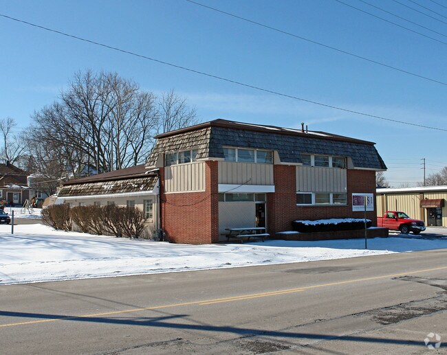
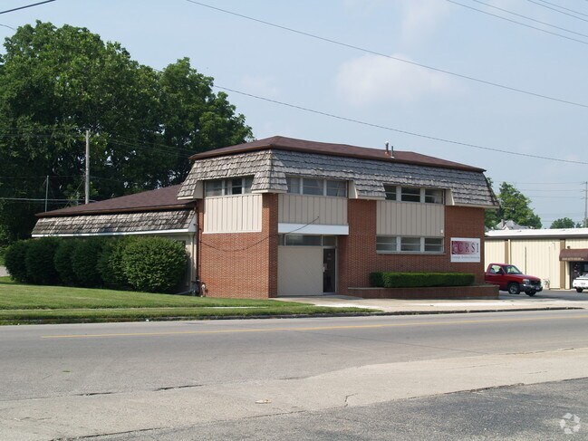

This Property Is For Sale
NEARBY LISTINGS FOR SALE OR LEASE
Property Detail
1701 W Main St
Springfield, OH
Seever
34-00600-01020-5005
SEEVER ALL (10) 5
Commercialacreage
Clark
X
Ohio
39023C0187E
5
2023
0.18 AC
2024
Northeast Dayton
002100
Cincinnati/Dayton
DEMOGRAPHICS near 1701 W Main St
1 Mile
3 Mile
5 Mile
2024 Total Population
6,745
46,680
82,822
2029 Population
6,820
46,977
82,759
Pop Growth 2024-2029
+ 1.11%
+ 0.64%
(0.08%)
Average Age
38
39
41
2024 Total Households
2,666
18,520
34,143
HH Growth 2024-2029
+ 1.13%
+ 0.59%
(0.15%)
Median Household Inc
$34,317
$44,102
$50,451
Avg Household Size
2.30
2.30
2.30
2024 Avg HH Vehicles
2.00
2.00
2.00
Median Home Value
$85,221
$111,417
$132,353
Median Year Built
1947
1949
1956
Nearby Places
- Restaurants
- Banks
- Shops
- Fitness
- Groceries
PUBLIC TRANSPORTATION
AIRPORT
James M Cox Dayton International
DRIVE
WALK
Distance
James M Cox Dayton International
31 min
24.9 mi
Freight Ports
Port of Toledo
DRIVE
WALK
Distance
Port of Toledo
186 min
131.4 mi
Nearby Properties
Address
Land Use
TOTAL SIZE
Lot Size
Zoning
Address
Land Use
TOTAL SIZE
Lot Size
Zoning
1.20 AC
Address
Land Use
TOTAL SIZE
Lot Size
Zoning
479,515 SF
1.69 AC
Address
Land Use
TOTAL SIZE
Lot Size
Zoning
32.89 AC
Address
Land Use
TOTAL SIZE
Lot Size
Zoning
107.87 AC
Address
Land Use
TOTAL SIZE
Lot Size
Zoning
17,280 SF
14.32 AC
Address
Land Use
TOTAL SIZE
Lot Size
Zoning
Address
Land Use
TOTAL SIZE
Lot Size
Zoning
44.85 AC
Address
Land Use
TOTAL SIZE
Lot Size
Zoning
234,478 SF
59.28 AC
Address
Land Use
TOTAL SIZE
Lot Size
Zoning
103,458 SF
5.51 AC
Address
Land Use
TOTAL SIZE
Lot Size
Zoning
8,316 SF
34.41 AC
R-1
Address
Land Use
TOTAL SIZE
Lot Size
Zoning
61,376 SF
3.95 AC
Address
Land Use
TOTAL SIZE
Lot Size
Zoning
28,105 SF
1.40 AC
Address
Land Use
TOTAL SIZE
Lot Size
Zoning
218,901 SF
19.15 AC
Address
Land Use
TOTAL SIZE
Lot Size
Zoning
225,335 SF
22.73 AC
Address
Land Use
TOTAL SIZE
Lot Size
Zoning
Address
Land Use
TOTAL SIZE
Lot Size
Zoning
103,589 SF
59.28 AC
Address
Land Use
TOTAL SIZE
Lot Size
Zoning
Address
Land Use
TOTAL SIZE
Lot Size
Zoning
Address
Land Use
TOTAL SIZE
Lot Size
Zoning
160,352 SF
22.89 AC
Address
Land Use
TOTAL SIZE
Lot Size
Zoning
211,877 SF
24.01 AC
Address
Land Use
TOTAL SIZE
Lot Size
Zoning
1.05 AC
Address
Land Use
TOTAL SIZE
Lot Size
Zoning
56,381 SF
0.22 AC
Address
Land Use
TOTAL SIZE
Lot Size
Zoning
32,566 SF
1.90 AC
Address
Land Use
TOTAL SIZE
Lot Size
Zoning
Address
Land Use
TOTAL SIZE
Lot Size
Zoning
Address
Land Use
TOTAL SIZE
Lot Size
Zoning
Address
Land Use
TOTAL SIZE
Lot Size
Zoning
111,936 SF
7.04 AC
Address
Land Use
TOTAL SIZE
Lot Size
Zoning
Address
Land Use
TOTAL SIZE
Lot Size
Zoning
26.78 AC
Address
Land Use
TOTAL SIZE
Lot Size
Zoning
The World's #1 Commercial Real Estate Marketplace
Connect with us
© 2025 CoStar Group
The information above has been obtained from sources believed reliable. While we do not doubt its accuracy we have not verified it and make no guarantee, warranty or representation about it. It is your responsibility to independently confirm its accuracy and completeness. Any projections, opinions, assumptions, or estimates used are for example only and do not represent the current or future performance of the property. The value of this transaction to you depends on tax and other factors which should be evaluated by your tax, financial, and legal advisors. You and your advisors should conduct a careful, independent investigation of the property to determine to your satisfaction the suitability of the property for your needs.