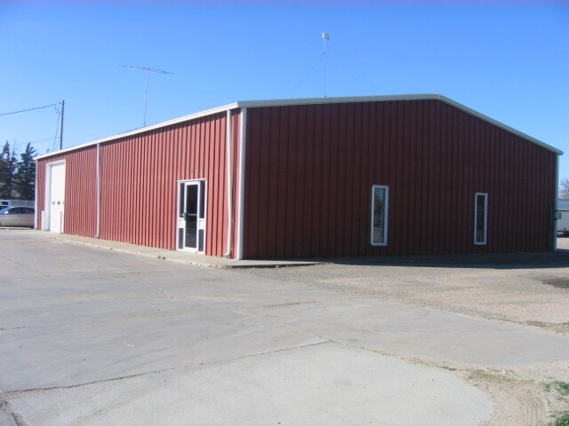
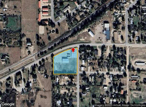
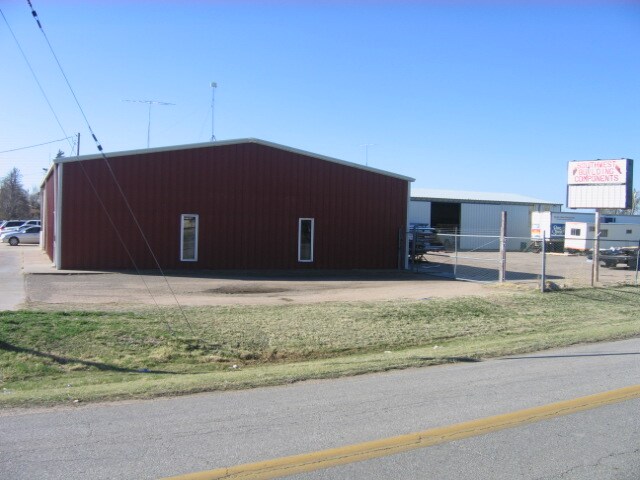
Property Record
1701 W Mcartor Rd, Dodge City, KS 67801
NEARBY LISTINGS FOR SALE OR LEASE
Property Detail
1701 W Mcartor Rd
Dodge City, KS
Sun-Crest Sub
172-03-0-10-10-001.00-0
SUN-CREST SUB, S03, T27, R25, LOT 10, ACRES 2
Warehouse
Ford
X
Kansas
20057C0331E
10
2025
2.02 AC
2025
Kansas Area
962000
Other Market Areas
3,750 SF
DEMOGRAPHICS near 1701 W Mcartor Rd
1 Mile
3 Mile
5 Mile
2024 Total Population
3,083
21,912
29,502
2029 Population
3,029
21,573
29,037
Pop Growth 2024-2029
(1.75%)
(1.55%)
(1.58%)
Average Age
34
33
34
2024 Total Households
1,007
6,887
9,588
HH Growth 2024-2029
(1.79%)
(1.58%)
(1.60%)
Median Household Inc
$39,955
$54,367
$61,037
Avg Household Size
3.00
3.10
3.00
2024 Avg HH Vehicles
2.00
2.00
2.00
Median Home Value
$114,091
$87,516
$123,239
Median Year Built
1966
1967
1971
Nearby Places
- Restaurants
- Banks
- Shops
- Fitness
- Groceries
PUBLIC TRANSPORTATION
COMMUTER RAIL
Dodge City Amtrak Station (Southwest Chief - Amtrak)
DRIVE
WALK
Distance
Dodge City Amtrak Station (Southwest Chief - Amtrak)
4 min
2.4 mi
Freight Ports
Tulsa Port Of Catoosa
DRIVE
WALK
Distance
Tulsa Port Of Catoosa
390 min
346.3 mi
Nearby Properties
Address
Land Use
TOTAL SIZE
Lot Size
Zoning
Address
Land Use
TOTAL SIZE
Lot Size
Zoning
390,187 SF
137.30 AC
Address
Land Use
TOTAL SIZE
Lot Size
Zoning
345,768 SF
39.04 AC
Address
Land Use
TOTAL SIZE
Lot Size
Zoning
213,605 SF
7.54 AC
Address
Land Use
TOTAL SIZE
Lot Size
Zoning
101,806 SF
36.58 AC
Address
Land Use
TOTAL SIZE
Lot Size
Zoning
198,802 SF
4.50 AC
Address
Land Use
TOTAL SIZE
Lot Size
Zoning
181,759 SF
107.80 AC
Address
Land Use
TOTAL SIZE
Lot Size
Zoning
57,670 SF
40 AC
Address
Land Use
TOTAL SIZE
Lot Size
Zoning
79,746 SF
2.10 AC
Address
Land Use
TOTAL SIZE
Lot Size
Zoning
63,557 SF
29.50 AC
Address
Land Use
TOTAL SIZE
Lot Size
Zoning
63,818 SF
4.06 AC
Address
Land Use
TOTAL SIZE
Lot Size
Zoning
37,310 SF
5.30 AC
Address
Land Use
TOTAL SIZE
Lot Size
Zoning
59,445 SF
30.50 AC
Address
Land Use
TOTAL SIZE
Lot Size
Zoning
61,521 SF
6.97 AC
Address
Land Use
TOTAL SIZE
Lot Size
Zoning
59,445 SF
10.63 AC
Address
Land Use
TOTAL SIZE
Lot Size
Zoning
7,956 SF
48.52 AC
Address
Land Use
TOTAL SIZE
Lot Size
Zoning
171,419 SF
4.70 AC
Address
Land Use
TOTAL SIZE
Lot Size
Zoning
28,704 SF
2.10 AC
Address
Land Use
TOTAL SIZE
Lot Size
Zoning
40,037 SF
0.35 AC
Address
Land Use
TOTAL SIZE
Lot Size
Zoning
59,246 SF
25.96 AC
Address
Land Use
TOTAL SIZE
Lot Size
Zoning
19,706 SF
1.40 AC
Address
Land Use
TOTAL SIZE
Lot Size
Zoning
27,986 SF
5.52 AC
Address
Land Use
TOTAL SIZE
Lot Size
Zoning
44,608 SF
0.81 AC
Address
Land Use
TOTAL SIZE
Lot Size
Zoning
3,600 SF
151.50 AC
Address
Land Use
TOTAL SIZE
Lot Size
Zoning
13,071 SF
2.23 AC
Address
Land Use
TOTAL SIZE
Lot Size
Zoning
13,727 SF
1.80 AC
Address
Land Use
TOTAL SIZE
Lot Size
Zoning
19,970 SF
5.60 AC
Address
Land Use
TOTAL SIZE
Lot Size
Zoning
8,075 SF
0.56 AC
Address
Land Use
TOTAL SIZE
Lot Size
Zoning
2,333 SF
110.60 AC
Address
Land Use
TOTAL SIZE
Lot Size
Zoning
194,180 SF
30.10 AC
Address
Land Use
TOTAL SIZE
Lot Size
Zoning
29,996 SF
4 AC
The World's #1 Commercial Real Estate Marketplace
Connect with us
© 2025 CoStar Group
The information above has been obtained from sources believed reliable. While we do not doubt its accuracy we have not verified it and make no guarantee, warranty or representation about it. It is your responsibility to independently confirm its accuracy and completeness. Any projections, opinions, assumptions, or estimates used are for example only and do not represent the current or future performance of the property. The value of this transaction to you depends on tax and other factors which should be evaluated by your tax, financial, and legal advisors. You and your advisors should conduct a careful, independent investigation of the property to determine to your satisfaction the suitability of the property for your needs.