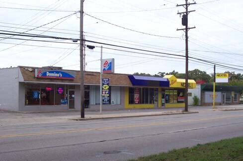
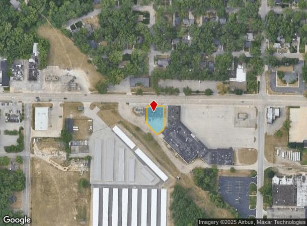
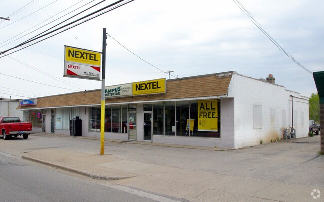
Property Record
1701 W Sherman Blvd, Norton Shores, MI 49441
NEARBY LISTINGS FOR SALE OR LEASE
Property Detail
1701 W Sherman Blvd
27-002-200-0018-00
CITY OF NORTON SHORES COM ON N LN OF SEC 2 T9N R17W 560 FT W OF NE COR OF SD SEC 2 TH S 33 FT FOR POB TH CONT S 129.09 FT
Commercialnec
Muskegon
X
Michigan
26121C0258E
0.31 AC
2024
Muskegon Heights
2025
West Michigan
002300
Muskegon, MI
5,000 SF
DEMOGRAPHICS near 1701 W Sherman Blvd
1 Mile
3 Mile
5 Mile
2024 Total Population
9,663
47,496
86,222
2029 Population
9,657
48,065
87,014
Pop Growth 2024-2029
(0.06%)
+ 1.20%
+ 0.92%
Average Age
42
40
40
2024 Total Households
4,398
19,926
33,855
HH Growth 2024-2029
(0.09%)
+ 1.17%
+ 0.90%
Median Household Inc
$53,484
$47,552
$50,122
Avg Household Size
2.10
2.30
2.30
2024 Avg HH Vehicles
2.00
2.00
2.00
Median Home Value
$141,086
$141,816
$142,707
Median Year Built
1956
1955
1957
Nearby Places
Map Layers
Map Styles
 Street
 Aerial
- Restaurants
- Banks
- Shops
- Fitness
- Groceries
SALE & LEASE HISTORY
LISTING DATE
SALE/LEASE

Jun 11, 2018
For Sale
Nearby Properties
Address
Land Use
TOTAL SIZE
Lot Size
Zoning
Address
Land Use
TOTAL SIZE
Lot Size
Zoning
6,900 SF
165.61 AC
GI
Address
Land Use
TOTAL SIZE
Lot Size
Zoning
84,452 SF
6.82 AC
PUD
Address
Land Use
TOTAL SIZE
Lot Size
Zoning
249,032 SF
19.18 AC
MFR
Address
Land Use
TOTAL SIZE
Lot Size
Zoning
79,321 SF
4.28 AC
B-3
Address
Land Use
TOTAL SIZE
Lot Size
Zoning
184,130 SF
3.16 AC
FBC-MS
Address
Land Use
TOTAL SIZE
Lot Size
Zoning
41,382 SF
6.20 AC
PUD
Address
Land Use
TOTAL SIZE
Lot Size
Zoning
116,657 SF
1.60 AC
FBC-UR
Address
Land Use
TOTAL SIZE
Lot Size
Zoning
187,210 SF
23.22 AC
GI
Address
Land Use
TOTAL SIZE
Lot Size
Zoning
219,341 SF
18.55 AC
C-SE
Address
Land Use
TOTAL SIZE
Lot Size
Zoning
79,321 SF
5 AC
FBC-MS
Address
Land Use
TOTAL SIZE
Lot Size
Zoning
194,708 SF
15.59 AC
C-2
Address
Land Use
TOTAL SIZE
Lot Size
Zoning
142,000 SF
1.60 AC
FBC-DT
Address
Land Use
TOTAL SIZE
Lot Size
Zoning
350,378 SF
21.50 AC
GI
Address
Land Use
TOTAL SIZE
Lot Size
Zoning
33,750 SF
R
Address
Land Use
TOTAL SIZE
Lot Size
Zoning
124,416 SF
7.41 AC
MFR
Address
Land Use
TOTAL SIZE
Lot Size
Zoning
125,478 SF
7.90 AC
WM
Address
Land Use
TOTAL SIZE
Lot Size
Zoning
110,460 SF
12.26 AC
AR-8
Address
Land Use
TOTAL SIZE
Lot Size
Zoning
325,640 SF
49 AC
WM
Address
Land Use
TOTAL SIZE
Lot Size
Zoning
42,888 SF
2.10 AC
R
Address
Land Use
TOTAL SIZE
Lot Size
Zoning
212,648 SF
9.20 AC
B-2, PUD
Address
Land Use
TOTAL SIZE
Lot Size
Zoning
399,872 SF
16.99 AC
I-2
Address
Land Use
TOTAL SIZE
Lot Size
Zoning
32,811 SF
5.87 AC
B-4
Address
Land Use
TOTAL SIZE
Lot Size
Zoning
121,766 SF
10.29 AC
C-NE
Address
Land Use
TOTAL SIZE
Lot Size
Zoning
123,081 SF
8.50 AC
B-4
Address
Land Use
TOTAL SIZE
Lot Size
Zoning
224,070 SF
15.85 AC
GI
Address
Land Use
TOTAL SIZE
Lot Size
Zoning
67,896 SF
8.56 AC
B-4
Address
Land Use
TOTAL SIZE
Lot Size
Zoning
1,020 SF
90.15 AC
PUD
Address
Land Use
TOTAL SIZE
Lot Size
Zoning
51,021 SF
5.52 AC
PUD
Address
Land Use
TOTAL SIZE
Lot Size
Zoning
56,341 SF
157.70 AC
R-1
Address
Land Use
TOTAL SIZE
Lot Size
Zoning
85,440 SF
4.51 AC
SUD
The World's #1 Commercial Real Estate Marketplace
Connect with us
© 2025 CoStar Group
The information above has been obtained from sources believed reliable. While we do not doubt its accuracy we have not verified it and make no guarantee, warranty or representation about it. It is your responsibility to independently confirm its accuracy and completeness. Any projections, opinions, assumptions, or estimates used are for example only and do not represent the current or future performance of the property. The value of this transaction to you depends on tax and other factors which should be evaluated by your tax, financial, and legal advisors. You and your advisors should conduct a careful, independent investigation of the property to determine to your satisfaction the suitability of the property for your needs.