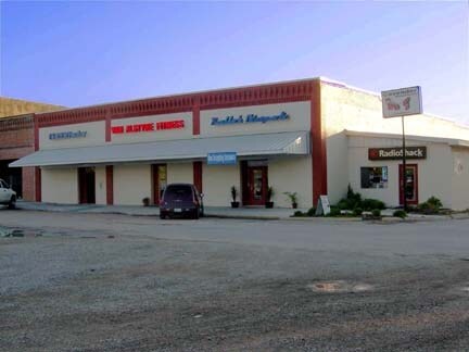
Property Record
170/176/18 N Main Dr, Van Alstyne, TX 75495
NEARBY LISTINGS FOR SALE OR LEASE
-
-
View all Van Alstyne listings for sale on LoopNet.com
Property Detail
170/176/18 N Main Dr
Sherman-Denison, TX
Otp Van Alstyne Addn
168231
OTP VAN ALSTYNE ADDN, BLOCK 4, LOT 8 9 & 10, ACRES .2152
Commercialnec
Grayson
X
Texas
48181C0550F
8
2024
0.22 AC
2025
Texas East Area
001803
Other Market Areas
DEMOGRAPHICS near 170/176/18 N Main Dr
1 Mile
3 Mile
5 Mile
2024 Total Population
4,530
9,226
22,687
2029 Population
5,274
10,858
27,479
Pop Growth 2024-2029
+ 16.42%
+ 17.69%
+ 21.12%
Average Age
38
38
36
2024 Total Households
1,666
3,280
7,560
HH Growth 2024-2029
+ 16.93%
+ 17.96%
+ 21.15%
Median Household Inc
$81,642
$81,880
$82,330
Avg Household Size
2.70
2.80
3.00
2024 Avg HH Vehicles
2.00
2.00
2.00
Median Home Value
$269,360
$290,200
$289,759
Median Year Built
2005
2007
2009
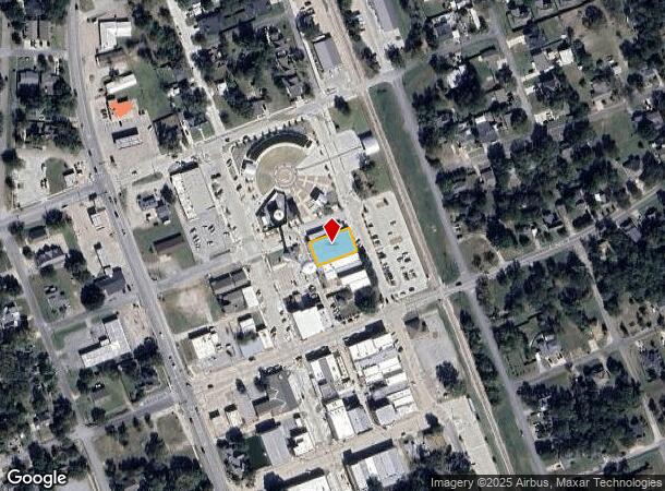
Nearby Places
Map Layers
Map Styles
 Street
 Aerial
- Restaurants
- Banks
- Shops
- Fitness
- Groceries
Nearby Properties
Address
Land Use
TOTAL SIZE
Lot Size
Zoning
Address
Land Use
TOTAL SIZE
Lot Size
Zoning
384,587 SF
87.97 AC
Address
Land Use
TOTAL SIZE
Lot Size
Zoning
93,400 SF
23.99 AC
Address
Land Use
TOTAL SIZE
Lot Size
Zoning
2,275 SF
319.29 AC
Address
Land Use
TOTAL SIZE
Lot Size
Zoning
2,275 SF
319.29 AC
Address
Land Use
TOTAL SIZE
Lot Size
Zoning
145,040 SF
7.73 AC
Address
Land Use
TOTAL SIZE
Lot Size
Zoning
69,392 SF
10.42 AC
Address
Land Use
TOTAL SIZE
Lot Size
Zoning
49,604 SF
86.82 AC
Address
Land Use
TOTAL SIZE
Lot Size
Zoning
140,180 SF
51.64 AC
Address
Land Use
TOTAL SIZE
Lot Size
Zoning
97,184 SF
27.06 AC
Address
Land Use
TOTAL SIZE
Lot Size
Zoning
90,350 SF
4.50 AC
Address
Land Use
TOTAL SIZE
Lot Size
Zoning
12,872 SF
20 AC
Address
Land Use
TOTAL SIZE
Lot Size
Zoning
92.29 AC
Address
Land Use
TOTAL SIZE
Lot Size
Zoning
45,800 SF
12 AC
Address
Land Use
TOTAL SIZE
Lot Size
Zoning
109,656 SF
12.50 AC
Address
Land Use
TOTAL SIZE
Lot Size
Zoning
86,089 SF
4.75 AC
Address
Land Use
TOTAL SIZE
Lot Size
Zoning
150,000 SF
16.59 AC
Address
Land Use
TOTAL SIZE
Lot Size
Zoning
59,711 SF
6.71 AC
C
Address
Land Use
TOTAL SIZE
Lot Size
Zoning
9,840 SF
21.16 AC
Address
Land Use
TOTAL SIZE
Lot Size
Zoning
22,620 SF
18.34 AC
Address
Land Use
TOTAL SIZE
Lot Size
Zoning
35,748 SF
43.06 AC
Address
Land Use
TOTAL SIZE
Lot Size
Zoning
44,760 SF
4.19 AC
Address
Land Use
TOTAL SIZE
Lot Size
Zoning
750 SF
55.07 AC
Address
Land Use
TOTAL SIZE
Lot Size
Zoning
55.07 AC
Address
Land Use
TOTAL SIZE
Lot Size
Zoning
86,500 SF
8.72 AC
Address
Land Use
TOTAL SIZE
Lot Size
Zoning
59,770 SF
23.90 AC
Address
Land Use
TOTAL SIZE
Lot Size
Zoning
50,692 SF
5.04 AC
Address
Land Use
TOTAL SIZE
Lot Size
Zoning
63,156 SF
5.81 AC
Address
Land Use
TOTAL SIZE
Lot Size
Zoning
Address
Land Use
TOTAL SIZE
Lot Size
Zoning
28,500 SF
8.78 AC
Address
Land Use
TOTAL SIZE
Lot Size
Zoning
27,000 SF
1.61 AC
The World's #1 Commercial Real Estate Marketplace
Connect with us
© 2026 CoStar Group
The information above has been obtained from sources believed reliable. While we do not doubt its accuracy we have not verified it and make no guarantee, warranty or representation about it. It is your responsibility to independently confirm its accuracy and completeness. Any projections, opinions, assumptions, or estimates used are for example only and do not represent the current or future performance of the property. The value of this transaction to you depends on tax and other factors which should be evaluated by your tax, financial, and legal advisors. You and your advisors should conduct a careful, independent investigation of the property to determine to your satisfaction the suitability of the property for your needs.