Property Record
17018 Se Wax Rd, Kent, WA 98042


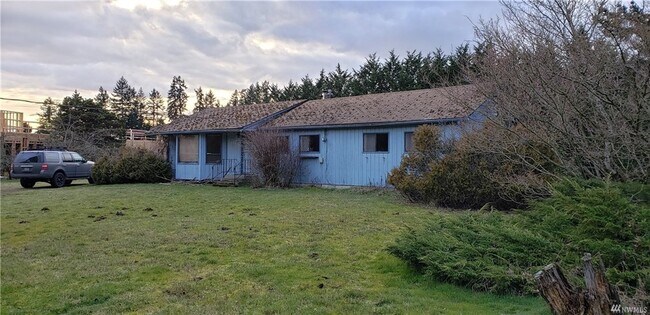
This Property Is For Sale
NEARBY LISTINGS FOR SALE OR LEASE
-
-
View all Kent listings for sale on LoopNet.com
Property Detail
17018 Se Wax Rd
Seattle-Tacoma-Bellevue, WA
King
362205-9080
Washington
Sfr
0.80 AC
X
E King County
53033C1280G
Seattle/Puget Sound
1,290 SF
DEMOGRAPHICS near 17018 Se Wax Rd
1 Mile
3 Mile
5 Mile
2024 Total Population
5,977
54,563
161,754
2029 Population
5,994
54,701
162,668
Pop Growth 2024-2029
+ 0.28%
+ 0.25%
+ 0.57%
Average Age
40
40
38
2024 Total Households
2,228
18,059
53,487
HH Growth 2024-2029
+ 0.13%
+ 0.04%
+ 0.36%
Median Household Inc
$81,481
$118,616
$108,715
Avg Household Size
2.70
2.90
2.90
2024 Avg HH Vehicles
2.00
2.00
2.00
Median Home Value
$604,244
$594,045
$581,160
Median Year Built
1991
1987
1989
Nearby Places
Map Layers
Map Styles
 Street
 Aerial
- Restaurants
- Banks
- Shops
- Fitness
- Groceries
PUBLIC TRANSPORTATION
COMMUTER RAIL
DRIVE
WALK
Distance
13 min
6.7 mi
Kent Station (Sounder South Line - Central Puget Sound Regional Transit Authority Rail (Link Light Rail/Sounder))
DRIVE
WALK
Distance
Kent Station (Sounder South Line - Central Puget Sound Regional Transit Authority Rail (Link Light Rail/Sounder))
14 min
6.8 mi
AIRPORT
Seattle-Tacoma International
DRIVE
WALK
Distance
Seattle-Tacoma International
32 min
15.6 mi
Nearby Properties
Address
Land Use
TOTAL SIZE
Lot Size
Zoning
Address
Land Use
TOTAL SIZE
Lot Size
Zoning
253,354 SF
26.78 AC
MR-G
Address
Land Use
TOTAL SIZE
Lot Size
Zoning
180,306 SF
3.29 AC
TC
Address
Land Use
TOTAL SIZE
Lot Size
Zoning
153,000 SF
10.28 AC
MC
Address
Land Use
TOTAL SIZE
Lot Size
Zoning
189,800 SF
7.49 AC
MC
Address
Land Use
TOTAL SIZE
Lot Size
Zoning
126,360 SF
2.22 AC
TC
Address
Land Use
TOTAL SIZE
Lot Size
Zoning
157,675 SF
7.59 AC
MR-H
Address
Land Use
TOTAL SIZE
Lot Size
Zoning
148,248 SF
9.14 AC
MR-G
Address
Land Use
TOTAL SIZE
Lot Size
Zoning
131,765 SF
13.22 AC
TC
Address
Land Use
TOTAL SIZE
Lot Size
Zoning
174,631 SF
40.11 AC
R6
Address
Land Use
TOTAL SIZE
Lot Size
Zoning
124,220 SF
14.52 AC
CC
Address
Land Use
TOTAL SIZE
Lot Size
Zoning
34,300 SF
8.39 AC
TC
Address
Land Use
TOTAL SIZE
Lot Size
Zoning
3,589 SF
43.26 AC
I
Address
Land Use
TOTAL SIZE
Lot Size
Zoning
90 AC
IP
Address
Land Use
TOTAL SIZE
Lot Size
Zoning
66,062 SF
8.97 AC
GC
Address
Land Use
TOTAL SIZE
Lot Size
Zoning
123,911 SF
24.63 AC
R6
Address
Land Use
TOTAL SIZE
Lot Size
Zoning
184,356 SF
36.80 AC
R1
Address
Land Use
TOTAL SIZE
Lot Size
Zoning
73,168 SF
6.91 AC
TC
Address
Land Use
TOTAL SIZE
Lot Size
Zoning
157,632 SF
18.74 AC
MC
Address
Land Use
TOTAL SIZE
Lot Size
Zoning
1,400 SF
10.43 AC
I
Address
Land Use
TOTAL SIZE
Lot Size
Zoning
3,750 SF
79.11 AC
RCMU
Address
Land Use
TOTAL SIZE
Lot Size
Zoning
174,877 SF
14.50 AC
MC
Address
Land Use
TOTAL SIZE
Lot Size
Zoning
10,095 SF
3.85 AC
MC
Address
Land Use
TOTAL SIZE
Lot Size
Zoning
133,818 SF
13.89 AC
MC
Address
Land Use
TOTAL SIZE
Lot Size
Zoning
140,304 SF
9.17 AC
MC
Address
Land Use
TOTAL SIZE
Lot Size
Zoning
16,850 SF
4.87 AC
C1
Address
Land Use
TOTAL SIZE
Lot Size
Zoning
16,190 SF
3.67 AC
MC
Address
Land Use
TOTAL SIZE
Lot Size
Zoning
90,480 SF
1.24 AC
MC
Address
Land Use
TOTAL SIZE
Lot Size
Zoning
8,900 SF
1.74 AC
TC
Address
Land Use
TOTAL SIZE
Lot Size
Zoning
97,843 SF
6.46 AC
MC
The World's #1 Commercial Real Estate Marketplace
Connect with us
© 2025 CoStar Group
The information above has been obtained from sources believed reliable. While we do not doubt its accuracy we have not verified it and make no guarantee, warranty or representation about it. It is your responsibility to independently confirm its accuracy and completeness. Any projections, opinions, assumptions, or estimates used are for example only and do not represent the current or future performance of the property. The value of this transaction to you depends on tax and other factors which should be evaluated by your tax, financial, and legal advisors. You and your advisors should conduct a careful, independent investigation of the property to determine to your satisfaction the suitability of the property for your needs.