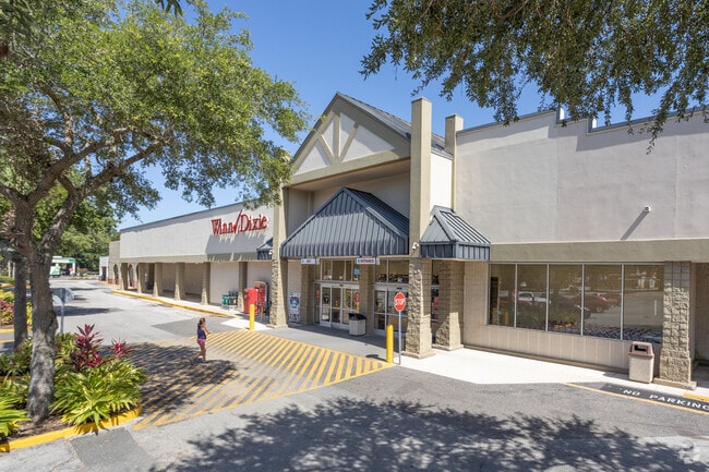
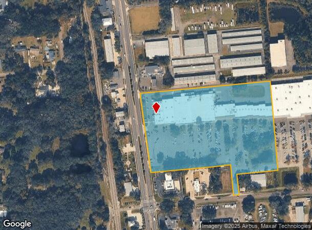
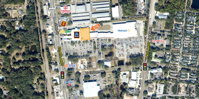
Property Record
1722 S 8Th St, Fernandina Beach, FL 32034

Current Lease Availabilities
NEARBY LISTINGS FOR SALE OR LEASE
Property Detail
1722 S 8Th St
Jacksonville, FL
Together With Alley Thru Said Lots
00-00-30-0800-0012-0000
LOT 12 & PT OF LOT 15 IN OR 2411/171 EX ESMT OR 262/356 & 602/1016 ESMT IN OR 451/536 ESMT IN OR 494/1155 PT W1/2 OF ALLEY E OF LOT 12 & PT OF LOT 15 SUB OF SEC 30 PB 1/5
Regionalshoppingcenterormallwithanchorstore
Nassau
X
Florida
12089C0239G
12
2025
10.79 AC
2025
Nassau County
050204
Jacksonville (Florida)
92,988 SF
DEMOGRAPHICS near 1722 S 8Th St
1 Mile
3 Mile
5 Mile
2024 Total Population
5,902
21,411
36,536
2029 Population
7,190
26,095
44,566
Pop Growth 2024-2029
+ 21.82%
+ 21.88%
+ 21.98%
Average Age
50
51
50
2024 Total Households
2,666
9,824
16,299
HH Growth 2024-2029
+ 22.81%
+ 23.09%
+ 23.23%
Median Household Inc
$71,824
$81,829
$84,684
Avg Household Size
2.10
2.10
2.20
2024 Avg HH Vehicles
2.00
2.00
2.00
Median Home Value
$370,422
$403,468
$420,703
Median Year Built
1993
1987
1995
Nearby Places
- Restaurants
- Banks
- Shops
- Fitness
- Groceries
PUBLIC TRANSPORTATION
AIRPORT
Jacksonville International
DRIVE
WALK
Distance
Jacksonville International
40 min
23.6 mi
Freight Ports
Jacksonville Port
DRIVE
WALK
Distance
Jacksonville Port
50 min
35.1 mi
Nearby Properties
Address
Land Use
TOTAL SIZE
Lot Size
Zoning
Address
Land Use
TOTAL SIZE
Lot Size
Zoning
163,465 SF
32.11 AC
PI-1
Address
Land Use
TOTAL SIZE
Lot Size
Zoning
240,175 SF
21.39 AC
R-3
Address
Land Use
TOTAL SIZE
Lot Size
Zoning
97,988 SF
513.95 AC
I-1
Address
Land Use
TOTAL SIZE
Lot Size
Zoning
166,870 SF
56.91 AC
PI-1
Address
Land Use
TOTAL SIZE
Lot Size
Zoning
1,056,049 SF
20.84 AC
I-2
Address
Land Use
TOTAL SIZE
Lot Size
Zoning
221,536 SF
11.16 AC
C-2
Address
Land Use
TOTAL SIZE
Lot Size
Zoning
210,460 SF
4.73 AC
C-1
Address
Land Use
TOTAL SIZE
Lot Size
Zoning
99,805 SF
15.24 AC
C-1
Address
Land Use
TOTAL SIZE
Lot Size
Zoning
505,582 SF
146.44 AC
CON
Address
Land Use
TOTAL SIZE
Lot Size
Zoning
2,190 SF
5.02 AC
IW
Address
Land Use
TOTAL SIZE
Lot Size
Zoning
95,223 SF
13.82 AC
PI-1
Address
Land Use
TOTAL SIZE
Lot Size
Zoning
102,059 SF
3.53 AC
C-1
Address
Land Use
TOTAL SIZE
Lot Size
Zoning
80,687 SF
1.42 AC
C-3
Address
Land Use
TOTAL SIZE
Lot Size
Zoning
106,517 SF
16.54 AC
PI-1
Address
Land Use
TOTAL SIZE
Lot Size
Zoning
818 SF
12.29 AC
IW
Address
Land Use
TOTAL SIZE
Lot Size
Zoning
1,382 SF
7.60 AC
REC
Address
Land Use
TOTAL SIZE
Lot Size
Zoning
Address
Land Use
TOTAL SIZE
Lot Size
Zoning
78,935 SF
16.60 AC
PI-1
Address
Land Use
TOTAL SIZE
Lot Size
Zoning
31,707 SF
1.34 AC
C-3
Address
Land Use
TOTAL SIZE
Lot Size
Zoning
55,200 SF
3.24 AC
C-1
Address
Land Use
TOTAL SIZE
Lot Size
Zoning
109,630 SF
12.59 AC
C-2
Address
Land Use
TOTAL SIZE
Lot Size
Zoning
22,776 SF
6.48 AC
REC
Address
Land Use
TOTAL SIZE
Lot Size
Zoning
21,240 SF
5.84 AC
C-2
Address
Land Use
TOTAL SIZE
Lot Size
Zoning
34,378 SF
12.91 AC
PI-1
Address
Land Use
TOTAL SIZE
Lot Size
Zoning
125,409 SF
8.44 AC
C-2
Address
Land Use
TOTAL SIZE
Lot Size
Zoning
1,920 SF
18.38 AC
I-1
Address
Land Use
TOTAL SIZE
Lot Size
Zoning
41,010 SF
2.10 AC
C-1
Address
Land Use
TOTAL SIZE
Lot Size
Zoning
62,689 SF
6.79 AC
C-1
Address
Land Use
TOTAL SIZE
Lot Size
Zoning
54,600 SF
6.83 AC
RG-1
Address
Land Use
TOTAL SIZE
Lot Size
Zoning
39,704 SF
3.68 AC
C-2
The World's #1 Commercial Real Estate Marketplace
Connect with us
© 2025 CoStar Group
The information above has been obtained from sources believed reliable. While we do not doubt its accuracy we have not verified it and make no guarantee, warranty or representation about it. It is your responsibility to independently confirm its accuracy and completeness. Any projections, opinions, assumptions, or estimates used are for example only and do not represent the current or future performance of the property. The value of this transaction to you depends on tax and other factors which should be evaluated by your tax, financial, and legal advisors. You and your advisors should conduct a careful, independent investigation of the property to determine to your satisfaction the suitability of the property for your needs.