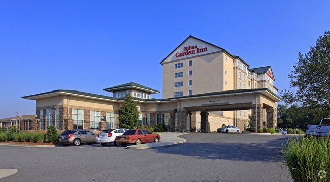
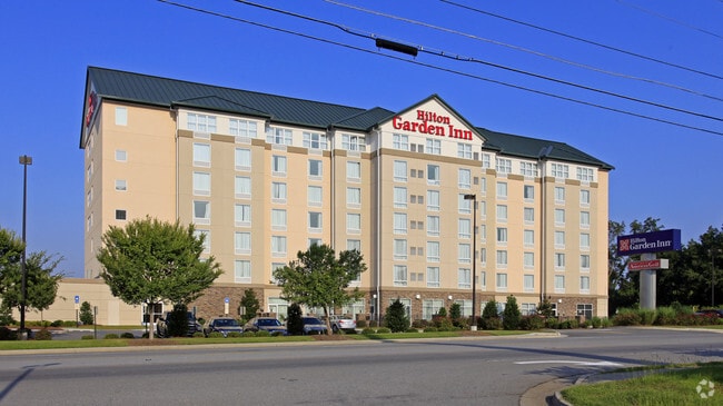
Property Record
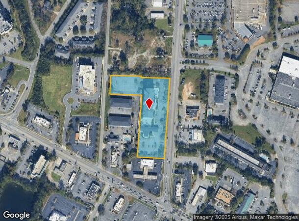
1702 Gornto Rd, Valdosta, GA 31601
NEARBY LISTINGS FOR SALE OR LEASE
Property Detail
1702 Gornto Rd
0081D-028A
Mall Area
Hotel
TRACT 1 3.0 AC
X
Lowndes
13027C0280D
Georgia
2024
3 AC
2024
Valdosta/Lake Park
011301
Other Market Areas
80,062 SF
Valdosta, GA
DEMOGRAPHICS near 1702 Gornto Rd
1 Mile
3 Mile
5 Mile
2024 Total Population
4,174
27,409
65,799
2029 Population
4,333
28,394
68,239
Pop Growth 2024-2029
+ 3.81%
+ 3.59%
+ 3.71%
Average Age
35
35
35
2024 Total Households
1,837
10,864
25,807
HH Growth 2024-2029
+ 3.76%
+ 3.87%
+ 3.89%
Median Household Inc
$28,800
$32,110
$34,111
Avg Household Size
2.20
2.20
2.40
2024 Avg HH Vehicles
2.00
2.00
2.00
Median Home Value
$169,156
$169,738
$158,600
Median Year Built
1989
1981
1986
Nearby Places
Map Layers
Map Styles
 Street
 Aerial
- Restaurants
- Banks
- Shops
- Fitness
- Groceries
PUBLIC TRANSPORTATION
AIRPORT
Valdosta Regional
DRIVE
WALK
Distance
Valdosta Regional
11 min
6.1 mi
Freight Ports
Jacksonville Port
DRIVE
WALK
Distance
Jacksonville Port
143 min
126.2 mi
Nearby Properties
Address
Land Use
TOTAL SIZE
Lot Size
Zoning
Address
Land Use
TOTAL SIZE
Lot Size
Zoning
459,770 SF
31.50 AC
C-H
Address
Land Use
TOTAL SIZE
Lot Size
Zoning
115,460 SF
13.09 AC
R-M
Address
Land Use
TOTAL SIZE
Lot Size
Zoning
1,728 SF
24.30 AC
R-P, C-C
Address
Land Use
TOTAL SIZE
Lot Size
Zoning
210,020 SF
4.22 AC
C-C
Address
Land Use
TOTAL SIZE
Lot Size
Zoning
15.75 AC
R-P
Address
Land Use
TOTAL SIZE
Lot Size
Zoning
1,686 SF
18.88 AC
R-M
Address
Land Use
TOTAL SIZE
Lot Size
Zoning
163,083 SF
17.16 AC
C-H
Address
Land Use
TOTAL SIZE
Lot Size
Zoning
150,802 SF
11.97 AC
M-1
Address
Land Use
TOTAL SIZE
Lot Size
Zoning
203,741 SF
22.55 AC
C-H
Address
Land Use
TOTAL SIZE
Lot Size
Zoning
120,720 SF
11.31 AC
C-H
Address
Land Use
TOTAL SIZE
Lot Size
Zoning
32,886 SF
5.45 AC
C-C
Address
Land Use
TOTAL SIZE
Lot Size
Zoning
104,544 SF
20.31 AC
R-M
Address
Land Use
TOTAL SIZE
Lot Size
Zoning
114,922 SF
11.38 AC
C-C
Address
Land Use
TOTAL SIZE
Lot Size
Zoning
104,423 SF
2.62 AC
C-H
Address
Land Use
TOTAL SIZE
Lot Size
Zoning
142,140 SF
24.29 AC
DR-10
Address
Land Use
TOTAL SIZE
Lot Size
Zoning
101,792 SF
14.09 AC
C-H
Address
Land Use
TOTAL SIZE
Lot Size
Zoning
97,568 SF
3.63 AC
C-H
Address
Land Use
TOTAL SIZE
Lot Size
Zoning
89,977 SF
11.16 AC
C-H
Address
Land Use
TOTAL SIZE
Lot Size
Zoning
101,774 SF
3.55 AC
C-H
Address
Land Use
TOTAL SIZE
Lot Size
Zoning
50,016 SF
3.79 AC
C-C
Address
Land Use
TOTAL SIZE
Lot Size
Zoning
120,400 SF
9.12 AC
M-1
Address
Land Use
TOTAL SIZE
Lot Size
Zoning
100,812 SF
6.43 AC
R-M
Address
Land Use
TOTAL SIZE
Lot Size
Zoning
88,545 SF
9.09 AC
C-H
Address
Land Use
TOTAL SIZE
Lot Size
Zoning
55,599 SF
4.14 AC
C-H
Address
Land Use
TOTAL SIZE
Lot Size
Zoning
76,250 SF
3.05 AC
C-H
Address
Land Use
TOTAL SIZE
Lot Size
Zoning
93,032 SF
2.80 AC
C-H
Address
Land Use
TOTAL SIZE
Lot Size
Zoning
78,048 SF
9.18 AC
R-P
Address
Land Use
TOTAL SIZE
Lot Size
Zoning
59,044 SF
8.35 AC
C-C
Address
Land Use
TOTAL SIZE
Lot Size
Zoning
70,358 SF
8.41 AC
R-10
The World's #1 Commercial Real Estate Marketplace
Connect with us
© 2025 CoStar Group
The information above has been obtained from sources believed reliable. While we do not doubt its accuracy we have not verified it and make no guarantee, warranty or representation about it. It is your responsibility to independently confirm its accuracy and completeness. Any projections, opinions, assumptions, or estimates used are for example only and do not represent the current or future performance of the property. The value of this transaction to you depends on tax and other factors which should be evaluated by your tax, financial, and legal advisors. You and your advisors should conduct a careful, independent investigation of the property to determine to your satisfaction the suitability of the property for your needs.