Property Record
1702 Mineral Wells Hwy, Weatherford, TX 76088
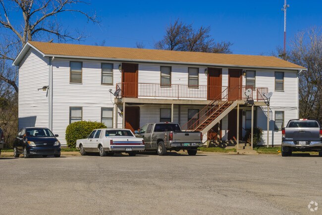


Property Detail
1702 Mineral Wells Hwy
R000065441
ACRES: 2.196 ABST: 2288, TR: WESTRIDGE APTS, BLK:, SURV: A J BALL
Apartment
Parker
B and X Area of moderate flood hazard, usually the area between the limits of the 100-year and 500-year floods.
Texas
2024
2.20 AC
2025
Outer Parker County
140502
Dallas/Ft Worth
14,160 SF
Dallas-Fort Worth-Arlington, TX
NEARBY LISTINGS FOR SALE OR LEASE
DEMOGRAPHICS near 1702 Mineral Wells Hwy
1 mile
3 mile
5 mile
2025 Total Population
3,534
27,192
47,300
2030 Population
4,079
31,629
55,122
Pop Growth 2025-2030
+ 15.42%
+ 16.32%
+ 16.54%
Average Age
38
40
40
2025 Total Households
1,334
10,580
18,004
HH Growth 2025-2030
+ 14.62%
+ 15.63%
+ 15.84%
Median Household Inc
$86,589
$69,935
$74,194
Avg Household Size
2.50
2.40
2.50
2025 Avg HH Vehicles
2.00
2.00
2.00
Median Home Value
$315,306
$310,255
$332,149
Median Year Built
1973
1989
1998
Nearby Places
Map Layers
Map Styles
 Street
 Aerial
Layers
 Traffic
 Biking
Places
Listings with unknown addresses are not visible on the map
- Restaurants
- Banks
- Shops
- Fitness
- Groceries
SALE & LEASE HISTORY
LISTING DATE
SALE/LEASE

Jun 02, 2023
For Sale
Nearby Properties
Address
Land Use
TOTAL SIZE
Lot Size
Zoning
Address
Land Use
TOTAL SIZE
Lot Size
Zoning
399,466 SF
11.50 AC
Address
Land Use
TOTAL SIZE
Lot Size
Zoning
64.64 AC
Address
Land Use
TOTAL SIZE
Lot Size
Zoning
279,600 SF
14.43 AC
Address
Land Use
TOTAL SIZE
Lot Size
Zoning
141,292 SF
13.88 AC
Address
Land Use
TOTAL SIZE
Lot Size
Zoning
171,147 SF
8.77 AC
Address
Land Use
TOTAL SIZE
Lot Size
Zoning
138,495 SF
13.83 AC
Address
Land Use
TOTAL SIZE
Lot Size
Zoning
103,600 SF
6 AC
Address
Land Use
TOTAL SIZE
Lot Size
Zoning
50,893 SF
10.37 AC
Address
Land Use
TOTAL SIZE
Lot Size
Zoning
210,698 SF
26.61 AC
Address
Land Use
TOTAL SIZE
Lot Size
Zoning
55,112 SF
4.68 AC
Address
Land Use
TOTAL SIZE
Lot Size
Zoning
81,112 SF
7.34 AC
Address
Land Use
TOTAL SIZE
Lot Size
Zoning
27,669 SF
3.58 AC
Address
Land Use
TOTAL SIZE
Lot Size
Zoning
26,050 SF
5.44 AC
Address
Land Use
TOTAL SIZE
Lot Size
Zoning
103,125 SF
18.25 AC
Address
Land Use
TOTAL SIZE
Lot Size
Zoning
155,253 SF
9.31 AC
Address
Land Use
TOTAL SIZE
Lot Size
Zoning
103,631 SF
7.78 AC
Address
Land Use
TOTAL SIZE
Lot Size
Zoning
146,651 SF
7.73 AC
Address
Land Use
TOTAL SIZE
Lot Size
Zoning
109,420 SF
14.61 AC
Address
Land Use
TOTAL SIZE
Lot Size
Zoning
62,856 SF
5.17 AC
Address
Land Use
TOTAL SIZE
Lot Size
Zoning
22,356 SF
0.17 AC
Address
Land Use
TOTAL SIZE
Lot Size
Zoning
210,342 SF
5 AC
Address
Land Use
TOTAL SIZE
Lot Size
Zoning
56,052 SF
5.40 AC
Address
Land Use
TOTAL SIZE
Lot Size
Zoning
107,388 SF
6.62 AC
Address
Land Use
TOTAL SIZE
Lot Size
Zoning
55,236 SF
4.69 AC
Address
Land Use
TOTAL SIZE
Lot Size
Zoning
11,707 SF
40.10 AC
Address
Land Use
TOTAL SIZE
Lot Size
Zoning
25,496 SF
2.70 AC
Address
Land Use
TOTAL SIZE
Lot Size
Zoning
52,750 SF
4.05 AC
Address
Land Use
TOTAL SIZE
Lot Size
Zoning
1,582 SF
0.58 AC
Address
Land Use
TOTAL SIZE
Lot Size
Zoning
33,650 SF
4 AC
Address
Land Use
TOTAL SIZE
Lot Size
Zoning
27,760 SF
10.50 AC
The World's #1 Commercial Real Estate Marketplace
Connect with us
© 2026 CoStar Group
The information above has been obtained from sources believed reliable. While we do not doubt its accuracy we have not verified it and make no guarantee, warranty or representation about it. It is your responsibility to independently confirm its accuracy and completeness. Any projections, opinions, assumptions, or estimates used are for example only and do not represent the current or future performance of the property. The value of this transaction to you depends on tax and other factors which should be evaluated by your tax, financial, and legal advisors. You and your advisors should conduct a careful, independent investigation of the property to determine to your satisfaction the suitability of the property for your needs.