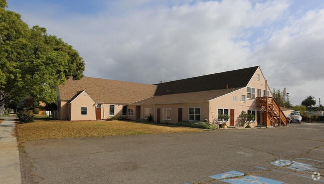
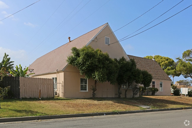
Property Record
1702 S Ditmar St, Oceanside, CA 92054


Save to a Folder
{{folder.Name}}
{{folder.ListingIds.length}} Properties
{{folder.ListingIds.length}} Property
Create a New Folder
Property Detail
1702 S Ditmar St
153-221-44
BLK 41 LOTS B&C&L&M&N ALLEY CLSD ADJ& TR 000622
Religious
San Diego
RS
California
B and X Area of moderate flood hazard, usually the area between the limits of the 100-year and 500-year floods.
b,c
2025
0.76 AC
2026
Oceanside
018101
San Diego
8,866 SF
San Diego-Chula Vista-Carlsbad, CA
NEARBY LISTINGS FOR SALE OR LEASE
-
-
View all Oceanside listings for sale on LoopNet.com
DEMOGRAPHICS near 1702 S Ditmar St
1 mile
3 mile
5 mile
2025 Total Population
12,054
82,655
173,528
2030 Population
12,292
83,980
175,452
Pop Growth 2025-2030
+ 1.97%
+ 1.60%
+ 1.11%
Average Age
42
40
40
2025 Total Households
5,191
33,204
64,329
HH Growth 2025-2030
+ 2.06%
+ 1.82%
+ 1.26%
Median Household Inc
$101,102
$89,528
$94,137
Avg Household Size
2.20
2.40
2.50
2025 Avg HH Vehicles
2.00
2.00
2.00
Median Home Value
$1,022,248
$975,381
$852,930
Median Year Built
1969
1977
1982
Nearby Places
Map Layers
Map Styles
 Street
 Aerial
Layers
 Traffic
 Biking
Places
Listings with unknown addresses are not visible on the map
- Restaurants
- Banks
- Shops
- Fitness
- Groceries
PUBLIC TRANSPORTATION
COMMUTER RAIL
Carlsbad Village (Coaster - San Diego North County Transit District (Coaster/Sprinter/Breeze))
Drive
Walk
Distance
Carlsbad Village (Coaster - San Diego North County Transit District (Coaster/Sprinter/Breeze))
5 min
1.5 mi
Oceanside Transit Center (Orange County Line - Southern California Regional Rail Authority (Metrolink))
Drive
Walk
Distance
Oceanside Transit Center (Orange County Line - Southern California Regional Rail Authority (Metrolink))
6 min
1.9 mi
AIRPORT
San Diego International
Drive
Walk
Distance
San Diego International
43 min
34.3 mi
Freight Ports
Port of San Diego
Drive
Walk
Distance
Port of San Diego
49 min
38.8 mi
Nearby Properties
Address
Land Use
TOTAL SIZE
Lot Size
Zoning
Address
Land Use
TOTAL SIZE
Lot Size
Zoning
9,999 SF
5.28 AC
C2
Address
Land Use
TOTAL SIZE
Lot Size
Zoning
9,999 SF
1.38 AC
C
Address
Land Use
TOTAL SIZE
Lot Size
Zoning
9,999 SF
16 AC
P-C
Address
Land Use
TOTAL SIZE
Lot Size
Zoning
9,999 SF
1.38 AC
C
Address
Land Use
TOTAL SIZE
Lot Size
Zoning
9,999 SF
1.14 AC
C
Address
Land Use
TOTAL SIZE
Lot Size
Zoning
5,000 SF
4.40 AC
CC
Address
Land Use
TOTAL SIZE
Lot Size
Zoning
9,999 SF
10.63 AC
RD-M
Address
Land Use
TOTAL SIZE
Lot Size
Zoning
9,999 SF
19.51 AC
C-2-Q
Address
Land Use
TOTAL SIZE
Lot Size
Zoning
2.30 AC
V-R
Address
Land Use
TOTAL SIZE
Lot Size
Zoning
9,999 SF
1.02 AC
D-1
Address
Land Use
TOTAL SIZE
Lot Size
Zoning
9,999 SF
6.63 AC
RD-M
Address
Land Use
TOTAL SIZE
Lot Size
Zoning
7,905 SF
2.16 AC
R-3
Address
Land Use
TOTAL SIZE
Lot Size
Zoning
9,999 SF
1.34 AC
V-B
Address
Land Use
TOTAL SIZE
Lot Size
Zoning
4.68 AC
D-6B
Address
Land Use
TOTAL SIZE
Lot Size
Zoning
12.72 AC
CC
Address
Land Use
TOTAL SIZE
Lot Size
Zoning
4,722 SF
2.17 AC
D-1
Address
Land Use
TOTAL SIZE
Lot Size
Zoning
6,024 SF
6.92 AC
VC
Address
Land Use
TOTAL SIZE
Lot Size
Zoning
2,481 SF
9.53 AC
CG-PBD
Address
Land Use
TOTAL SIZE
Lot Size
Zoning
6,942 SF
4.49 AC
R-3
Address
Land Use
TOTAL SIZE
Lot Size
Zoning
9,999 SF
9.59 AC
RD-M-Q
Address
Land Use
TOTAL SIZE
Lot Size
Zoning
9,587 SF
0.69 AC
V-R
Address
Land Use
TOTAL SIZE
Lot Size
Zoning
9,999 SF
9.52 AC
CS-HO
Address
Land Use
TOTAL SIZE
Lot Size
Zoning
9,999 SF
10.15 AC
P-C
Address
Land Use
TOTAL SIZE
Lot Size
Zoning
9,999 SF
16.32 AC
PD-3
Address
Land Use
TOTAL SIZE
Lot Size
Zoning
80,720 SF
0.90 AC
C
Address
Land Use
TOTAL SIZE
Lot Size
Zoning
70,000 SF
1.75 AC
V-R
Address
Land Use
TOTAL SIZE
Lot Size
Zoning
6,816 SF
9.55 AC
RH
Address
Land Use
TOTAL SIZE
Lot Size
Zoning
9,999 SF
12.19 AC
CS-HO
Address
Land Use
TOTAL SIZE
Lot Size
Zoning
3,177 SF
2.67 AC
C-6
Address
Land Use
TOTAL SIZE
Lot Size
Zoning
9,999 SF
10.29 AC
RM-B
The World's #1 Commercial Real Estate Marketplace
Connect with us
© 2026 CoStar Group
The information above has been obtained from sources believed reliable. While we do not doubt its accuracy we have not verified it and make no guarantee, warranty or representation about it. It is your responsibility to independently confirm its accuracy and completeness. Any projections, opinions, assumptions, or estimates used are for example only and do not represent the current or future performance of the property. The value of this transaction to you depends on tax and other factors which should be evaluated by your tax, financial, and legal advisors. You and your advisors should conduct a careful, independent investigation of the property to determine to your satisfaction the suitability of the property for your needs.