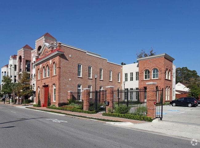
Property Record
1702 Washington Ave, Houston, TX 77007

Property Detail
1702 Washington Ave
Houston-Pasadena-The Woodlands, TX
LT 3 & 4 HEISS
0162010000004
HARRIS
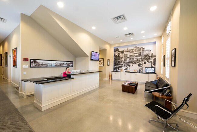
Officebuilding
Texas
B and X Area of moderate flood hazard, usually the area between the limits of the 100-year and 500-year floods.
3,4
2024
0.34 AC
2025
Midtown
510100
Houston
8,962 SF
NEARBY LISTINGS FOR SALE OR LEASE
DEMOGRAPHICS near 1702 Washington Ave
1 mile
3 mile
5 mile
2025 Total Population
19,546
231,688
497,790
2030 Population
21,482
252,015
539,317
Pop Growth 2025-2030
+ 9.90%
+ 8.77%
+ 8.34%
Average Age
36
38
38
2025 Total Households
10,948
112,514
222,567
HH Growth 2025-2030
+ 10.14%
+ 9.39%
+ 8.96%
Median Household Inc
$94,209
$100,942
$89,337
Avg Household Size
1.70
1.90
2.10
2025 Avg HH Vehicles
1.00
2.00
2.00
Median Home Value
$467,110
$498,541
$470,990
Median Year Built
2009
2002
1995
Nearby Places
Map Layers
Map Styles
 Street
 Aerial
Transit
 Traffic
 Biking
Places
Listings with unknown addresses are not visible on the map
- Restaurants
- Banks
- Shops
- Fitness
- Groceries
PUBLIC TRANSPORTATION
TRANSIT/SUBWAY
Dwntwn Line End (No Service) (METRORAIL GREEN LINE - Metropolitan Transit Authority of Harris County, METRORAIL PURPLE LINE - Metropolitan Transit Authority of Harris County)
Drive
Walk
Distance
Dwntwn Line End (No Service) (METRORAIL GREEN LINE - Metropolitan Transit Authority of Harris County, METRORAIL PURPLE LINE - Metropolitan Transit Authority of Harris County)
1 min
9 min
0.5 mi
Theater District Rusk Eb (METRORAIL GREEN LINE - Metropolitan Transit Authority of Harris County, METRORAIL PURPLE LINE - Metropolitan Transit Authority of Harris County)
Drive
Walk
Distance
Theater District Rusk Eb (METRORAIL GREEN LINE - Metropolitan Transit Authority of Harris County, METRORAIL PURPLE LINE - Metropolitan Transit Authority of Harris County)
1 min
14 min
0.7 mi
Theater District Capitol Wb (METRORAIL GREEN LINE - Metropolitan Transit Authority of Harris County, METRORAIL PURPLE LINE - Metropolitan Transit Authority of Harris County)
Drive
Walk
Distance
Theater District Capitol Wb (METRORAIL GREEN LINE - Metropolitan Transit Authority of Harris County, METRORAIL PURPLE LINE - Metropolitan Transit Authority of Harris County)
2 min
15 min
0.8 mi
Preston (Redline - Harris County Metropolitan Transit Authority METRO Rail (METRORail))
Drive
Walk
Distance
Preston (Redline - Harris County Metropolitan Transit Authority METRO Rail (METRORail))
2 min
18 min
0.9 mi
Central Stn Main Nb (METRORAIL RED LINE - Metropolitan Transit Authority of Harris County)
Drive
Walk
Distance
Central Stn Main Nb (METRORAIL RED LINE - Metropolitan Transit Authority of Harris County)
3 min
20 min
1.0 mi
COMMUTER RAIL
Houston (Sunset Limited - Amtrak)
Drive
Walk
Distance
Houston (Sunset Limited - Amtrak)
1 min
9 min
0.5 mi
AIRPORT
William P Hobby
Drive
Walk
Distance
William P Hobby
23 min
13.1 mi
George Bush Intcntl/Houston
Drive
Walk
Distance
George Bush Intcntl/Houston
26 min
20.0 mi
Freight Ports
Port of Houston
Drive
Walk
Distance
Port of Houston
19 min
10.8 mi
SALE & LEASE HISTORY
LISTING DATE
SALE/LEASE

Jul 10, 2020
For Lease
Nearby Properties
Address
Land Use
TOTAL SIZE
Lot Size
Zoning
Address
Land Use
TOTAL SIZE
Lot Size
Zoning
1,383,720 SF
1.47 AC
Address
Land Use
TOTAL SIZE
Lot Size
Zoning
1,101,686 SF
1.45 AC
Address
Land Use
TOTAL SIZE
Lot Size
Zoning
973,861 SF
1.18 AC
Address
Land Use
TOTAL SIZE
Lot Size
Zoning
899,279 SF
1.18 AC
Address
Land Use
TOTAL SIZE
Lot Size
Zoning
797,208 SF
1.46 AC
Address
Land Use
TOTAL SIZE
Lot Size
Zoning
1,916,394 SF
1.46 AC
Address
Land Use
TOTAL SIZE
Lot Size
Zoning
1,871,418 SF
1.44 AC
Address
Land Use
TOTAL SIZE
Lot Size
Zoning
1,091,726 SF
2.60 AC
Address
Land Use
TOTAL SIZE
Lot Size
Zoning
1,232,364 SF
1.49 AC
Address
Land Use
TOTAL SIZE
Lot Size
Zoning
1,436,400 SF
1.44 AC
Address
Land Use
TOTAL SIZE
Lot Size
Zoning
1,321,033 SF
1.46 AC
Address
Land Use
TOTAL SIZE
Lot Size
Zoning
4,169,721 SF
31.23 AC
Address
Land Use
TOTAL SIZE
Lot Size
Zoning
2,005,097 SF
1.44 AC
Address
Land Use
TOTAL SIZE
Lot Size
Zoning
1,374,271 SF
1.44 AC
Address
Land Use
TOTAL SIZE
Lot Size
Zoning
1,150,681 SF
1.17 AC
Address
Land Use
TOTAL SIZE
Lot Size
Zoning
515,025 SF
1.50 AC
Address
Land Use
TOTAL SIZE
Lot Size
Zoning
1,657,484 SF
1.44 AC
Address
Land Use
TOTAL SIZE
Lot Size
Zoning
1,282,908 SF
2.74 AC
Address
Land Use
TOTAL SIZE
Lot Size
Zoning
1,311,133 SF
1.44 AC
Address
Land Use
TOTAL SIZE
Lot Size
Zoning
555,351 SF
1.40 AC
Address
Land Use
TOTAL SIZE
Lot Size
Zoning
1,181,384 SF
1.47 AC
Address
Land Use
TOTAL SIZE
Lot Size
Zoning
1,162,204 SF
1.44 AC
Address
Land Use
TOTAL SIZE
Lot Size
Zoning
934,258 SF
1.45 AC
Address
Land Use
TOTAL SIZE
Lot Size
Zoning
1,103,424 SF
1.44 AC
Address
Land Use
TOTAL SIZE
Lot Size
Zoning
1,365,801 SF
1.44 AC
Address
Land Use
TOTAL SIZE
Lot Size
Zoning
644,352 SF
8.05 AC
Address
Land Use
TOTAL SIZE
Lot Size
Zoning
1,017,783 SF
1.44 AC
Address
Land Use
TOTAL SIZE
Lot Size
Zoning
1,182,525 SF
1.11 AC
Address
Land Use
TOTAL SIZE
Lot Size
Zoning
608,233 SF
2.23 AC
Address
Land Use
TOTAL SIZE
Lot Size
Zoning
930,730 SF
1.89 AC
The World's #1 Commercial Real Estate Marketplace
Connect with us
© 2026 CoStar Group
The information above has been obtained from sources believed reliable. While we do not doubt its accuracy we have not verified it and make no guarantee, warranty or representation about it. It is your responsibility to independently confirm its accuracy and completeness. Any projections, opinions, assumptions, or estimates used are for example only and do not represent the current or future performance of the property. The value of this transaction to you depends on tax and other factors which should be evaluated by your tax, financial, and legal advisors. You and your advisors should conduct a careful, independent investigation of the property to determine to your satisfaction the suitability of the property for your needs.