Property Record
17021 Lincoln Ave, Parker, CO 80134
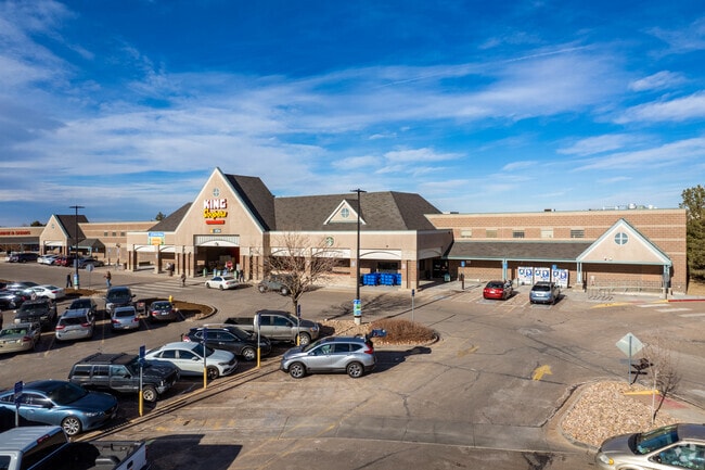
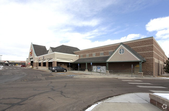
Property Detail
17021 Lincoln Ave
Denver-Aurora-Centennial, CO
LOT 3 THE CROSSING AT STONEGATE #1 6.138 AM/L
2233-162-09-003
DOUGLAS
Commercialnec
Colorado
B and X Area of moderate flood hazard, usually the area between the limits of the 100-year and 500-year floods.
3
2024
2.56 AC
2026
Southeast
014010
Denver
21,220 SF
NEARBY LISTINGS FOR SALE OR LEASE
DEMOGRAPHICS near 17021 Lincoln Ave
1 mile
3 mile
5 mile
2025 Total Population
14,026
73,753
150,352
2030 Population
14,979
79,288
160,539
Pop Growth 2025-2030
+ 6.79%
+ 7.50%
+ 6.78%
Average Age
38
37
38
2025 Total Households
5,151
27,031
56,690
HH Growth 2025-2030
+ 7.36%
+ 7.79%
+ 7.08%
Median Household Inc
$123,845
$121,963
$123,930
Avg Household Size
2.60
2.70
2.60
2025 Avg HH Vehicles
2.00
2.00
2.00
Median Home Value
$675,170
$693,855
$720,491
Median Year Built
2000
2004
2005
Nearby Places
Map Layers
Map Styles
 Street
 Aerial
Layers
 Traffic
 Biking
Places
Listings with unknown addresses are not visible on the map
- Restaurants
- Banks
- Shops
- Fitness
- Groceries
PUBLIC TRANSPORTATION
AIRPORT
Denver International
Drive
Walk
Distance
Denver International
33 min
29.7 mi
Freight Ports
Tulsa Port Of Catoosa
Drive
Walk
Distance
Tulsa Port Of Catoosa
726 min
709.5 mi
SALE & LEASE HISTORY
LISTING DATE
SALE/LEASE

Oct 28, 2021
For Lease
Nov 01, 2019
For Lease
Mar 03, 2025
For Lease
Feb 07, 2018
For Lease
Aug 03, 2020
For Lease
Nearby Properties
Address
Land Use
TOTAL SIZE
Lot Size
Zoning
Address
Land Use
TOTAL SIZE
Lot Size
Zoning
567,767 SF
33.84 AC
Address
Land Use
TOTAL SIZE
Lot Size
Zoning
621,565 SF
32.64 AC
PDU
Address
Land Use
TOTAL SIZE
Lot Size
Zoning
304,620 SF
23.95 AC
AMU
Address
Land Use
TOTAL SIZE
Lot Size
Zoning
494,489 SF
22.16 AC
Address
Land Use
TOTAL SIZE
Lot Size
Zoning
253,296 SF
16.41 AC
Address
Land Use
TOTAL SIZE
Lot Size
Zoning
181,361 SF
549.62 AC
Address
Land Use
TOTAL SIZE
Lot Size
Zoning
195,390 SF
14.78 AC
AI1
Address
Land Use
TOTAL SIZE
Lot Size
Zoning
207,872 SF
44.94 AC
PDU
Address
Land Use
TOTAL SIZE
Lot Size
Zoning
150,920 SF
12.18 AC
AA1
Address
Land Use
TOTAL SIZE
Lot Size
Zoning
190,344 SF
10.77 AC
PDU
Address
Land Use
TOTAL SIZE
Lot Size
Zoning
196,252 SF
17.14 AC
PDU
Address
Land Use
TOTAL SIZE
Lot Size
Zoning
140,080 SF
15.05 AC
Address
Land Use
TOTAL SIZE
Lot Size
Zoning
343,018 SF
15.13 AC
Address
Land Use
TOTAL SIZE
Lot Size
Zoning
344,128 SF
19.06 AC
Address
Land Use
TOTAL SIZE
Lot Size
Zoning
455,049 SF
16.96 AC
Address
Land Use
TOTAL SIZE
Lot Size
Zoning
132,601 SF
16.08 AC
Address
Land Use
TOTAL SIZE
Lot Size
Zoning
93,100 SF
8.78 AC
Address
Land Use
TOTAL SIZE
Lot Size
Zoning
149,928 SF
10.73 AC
Address
Land Use
TOTAL SIZE
Lot Size
Zoning
202,392 SF
21.13 AC
Address
Land Use
TOTAL SIZE
Lot Size
Zoning
442,567 SF
16.91 AC
Address
Land Use
TOTAL SIZE
Lot Size
Zoning
453,901 SF
16.34 AC
Address
Land Use
TOTAL SIZE
Lot Size
Zoning
160,000 SF
9.32 AC
Address
Land Use
TOTAL SIZE
Lot Size
Zoning
445,938 SF
19.85 AC
Address
Land Use
TOTAL SIZE
Lot Size
Zoning
329,204 SF
13.97 AC
Address
Land Use
TOTAL SIZE
Lot Size
Zoning
113,010 SF
21.48 AC
AMU
Address
Land Use
TOTAL SIZE
Lot Size
Zoning
53,500 SF
6 AC
Address
Land Use
TOTAL SIZE
Lot Size
Zoning
73,149 SF
14.10 AC
PDU
Address
Land Use
TOTAL SIZE
Lot Size
Zoning
375,171 SF
12.88 AC
Address
Land Use
TOTAL SIZE
Lot Size
Zoning
569,400 SF
42.82 AC
PDU
Address
Land Use
TOTAL SIZE
Lot Size
Zoning
77,277 SF
7.33 AC
The World's #1 Commercial Real Estate Marketplace
Connect with us
© 2026 CoStar Group
The information above has been obtained from sources believed reliable. While we do not doubt its accuracy we have not verified it and make no guarantee, warranty or representation about it. It is your responsibility to independently confirm its accuracy and completeness. Any projections, opinions, assumptions, or estimates used are for example only and do not represent the current or future performance of the property. The value of this transaction to you depends on tax and other factors which should be evaluated by your tax, financial, and legal advisors. You and your advisors should conduct a careful, independent investigation of the property to determine to your satisfaction the suitability of the property for your needs.