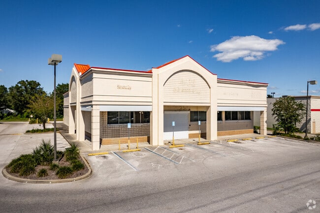
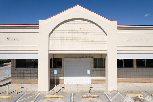
Property Record
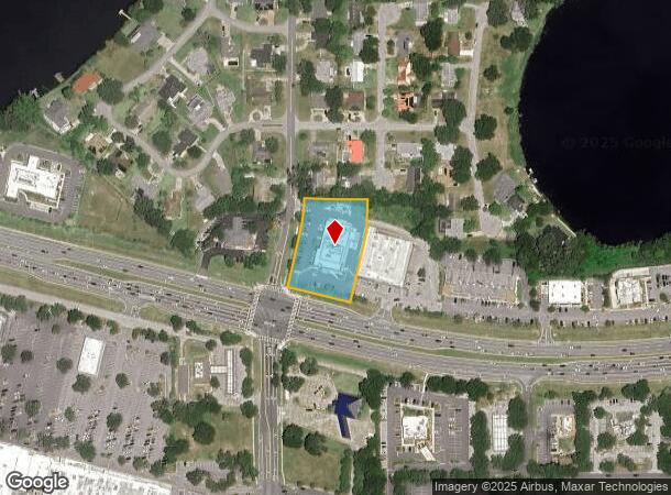
17021 Us Highway 441 Hwy, Eustis, FL 32726

NEARBY LISTINGS FOR SALE OR LEASE
Property Detail
17021 Us Highway 441 Hwy
Orlando-Kissimmee-Sanford, FL
Lake Louise Terrace Sub
24-19-26-0003-000-02900
BEG AT SW COR OF LOT 34 OF LAKE LOUISE TERRACE SUB RUN S 89DEG 07MIN 04SEC E 198 FT S 00DEG 52MIN 56SEC W 103.42 FT S 14DEG 00MIN 64SEC W 225.54 FT TO NLY R/W LINE OF US HWY 441 N 75DEG 39MIN 12SEC W ALONG SAID NLY R/W LINE 201.89 FT TO ELY R/W LINE
Hospitalpublic
Lake
X
Florida
12069C0317E
34
0
1.41 AC
2026
Lake County
030204
Orlando
11,097 SF
DEMOGRAPHICS near 17021 Us Highway 441 Hwy
1 Mile
3 Mile
5 Mile
2024 Total Population
5,763
45,516
74,147
2029 Population
6,642
53,059
86,369
Pop Growth 2024-2029
+ 15.25%
+ 16.57%
+ 16.48%
Average Age
42
44
45
2024 Total Households
2,494
19,570
31,654
HH Growth 2024-2029
+ 14.96%
+ 16.43%
+ 16.41%
Median Household Inc
$54,223
$54,858
$59,701
Avg Household Size
2.20
2.30
2.30
2024 Avg HH Vehicles
2.00
2.00
2.00
Median Home Value
$227,670
$237,712
$254,193
Median Year Built
1978
1981
1985
Nearby Places
Map Layers
Map Styles
 Street
 Aerial
- Restaurants
- Banks
- Shops
- Fitness
- Groceries
PUBLIC TRANSPORTATION
AIRPORT
Orlando Sanford International
DRIVE
WALK
Distance
Orlando Sanford International
52 min
35.5 mi
Freight Ports
Port Canaveral
DRIVE
WALK
Distance
Port Canaveral
110 min
90.0 mi
SALE & LEASE HISTORY
LISTING DATE
SALE/LEASE

Dec 15, 2021
For Lease
Nearby Properties
Address
Land Use
TOTAL SIZE
Lot Size
Zoning
Address
Land Use
TOTAL SIZE
Lot Size
Zoning
730,215 SF
151.42 AC
PD
Address
Land Use
TOTAL SIZE
Lot Size
Zoning
330,732 SF
35.24 AC
Address
Land Use
TOTAL SIZE
Lot Size
Zoning
302,511 SF
23.16 AC
Address
Land Use
TOTAL SIZE
Lot Size
Zoning
278,266 SF
23.85 AC
PD
Address
Land Use
TOTAL SIZE
Lot Size
Zoning
308,464 SF
37.14 AC
PUD
Address
Land Use
TOTAL SIZE
Lot Size
Zoning
226,508 SF
19.15 AC
Address
Land Use
TOTAL SIZE
Lot Size
Zoning
254,395 SF
20.59 AC
A
Address
Land Use
TOTAL SIZE
Lot Size
Zoning
158,442 SF
17.50 AC
MCI
Address
Land Use
TOTAL SIZE
Lot Size
Zoning
267,107 SF
20.40 AC
R1
Address
Land Use
TOTAL SIZE
Lot Size
Zoning
121,005 SF
6.56 AC
Address
Land Use
TOTAL SIZE
Lot Size
Zoning
85,539 SF
9.39 AC
Address
Land Use
TOTAL SIZE
Lot Size
Zoning
45,732 SF
5.68 AC
PD
Address
Land Use
TOTAL SIZE
Lot Size
Zoning
123,610 SF
6.96 AC
Address
Land Use
TOTAL SIZE
Lot Size
Zoning
204,433 SF
28.43 AC
R1
Address
Land Use
TOTAL SIZE
Lot Size
Zoning
135,298 SF
9.22 AC
SR
Address
Land Use
TOTAL SIZE
Lot Size
Zoning
190,551 SF
20.31 AC
GC
Address
Land Use
TOTAL SIZE
Lot Size
Zoning
72,852 SF
10.91 AC
Address
Land Use
TOTAL SIZE
Lot Size
Zoning
36,261 SF
6.27 AC
PD
Address
Land Use
TOTAL SIZE
Lot Size
Zoning
157,511 SF
15.28 AC
Address
Land Use
TOTAL SIZE
Lot Size
Zoning
36,462 SF
10.40 AC
Address
Land Use
TOTAL SIZE
Lot Size
Zoning
71,076 SF
1.42 AC
Address
Land Use
TOTAL SIZE
Lot Size
Zoning
79,296 SF
8.54 AC
R3
Address
Land Use
TOTAL SIZE
Lot Size
Zoning
54,248 SF
4.56 AC
R3
Address
Land Use
TOTAL SIZE
Lot Size
Zoning
129,512 SF
15 AC
Address
Land Use
TOTAL SIZE
Lot Size
Zoning
94,435 SF
8.16 AC
GC
Address
Land Use
TOTAL SIZE
Lot Size
Zoning
146,690 SF
15.19 AC
RMF2
Address
Land Use
TOTAL SIZE
Lot Size
Zoning
50,754 SF
17.31 AC
R1
Address
Land Use
TOTAL SIZE
Lot Size
Zoning
64,730 SF
6.38 AC
C3
Address
Land Use
TOTAL SIZE
Lot Size
Zoning
106,175 SF
8.10 AC
UR
Address
Land Use
TOTAL SIZE
Lot Size
Zoning
54,035 SF
1.65 AC
PD
The World's #1 Commercial Real Estate Marketplace
Connect with us
© 2025 CoStar Group
The information above has been obtained from sources believed reliable. While we do not doubt its accuracy we have not verified it and make no guarantee, warranty or representation about it. It is your responsibility to independently confirm its accuracy and completeness. Any projections, opinions, assumptions, or estimates used are for example only and do not represent the current or future performance of the property. The value of this transaction to you depends on tax and other factors which should be evaluated by your tax, financial, and legal advisors. You and your advisors should conduct a careful, independent investigation of the property to determine to your satisfaction the suitability of the property for your needs.