Property Record
1710 W Main St, Central, SC 29630
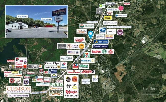
NEARBY LISTINGS FOR SALE OR LEASE
Property Detail
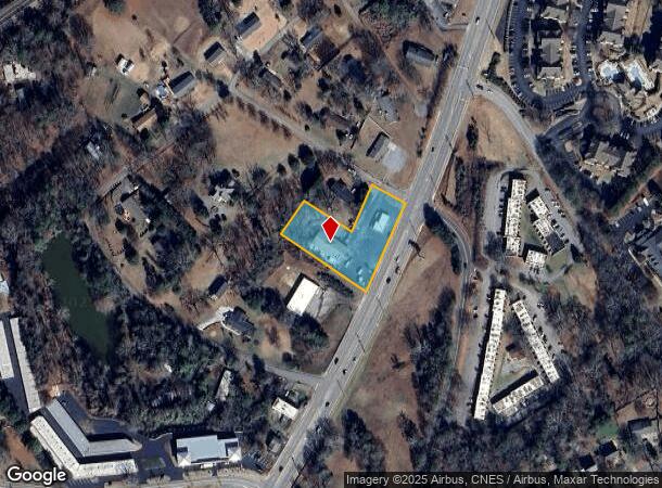
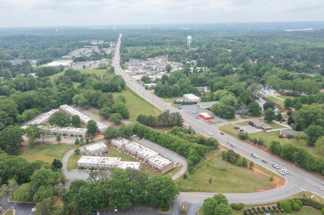
1710 W Main St
4065-17-00-8048
S/SIDE HEATHER HILL DR
Restaurantbuilding
Pickens
X
South Carolina
45007C0085E
1.22 AC
2025
Pickens County
2024
Greenville/Spartanburg
011104
Greenville-Anderson-Mauldin, SC
5,000 SF
DEMOGRAPHICS near 1710 W Main St
1 Mile
3 Mile
5 Mile
2024 Total Population
6,260
24,727
39,988
2029 Population
6,441
25,463
41,463
Pop Growth 2024-2029
+ 2.89%
+ 2.98%
+ 3.69%
Average Age
31
34
34
2024 Total Households
2,775
9,910
15,085
HH Growth 2024-2029
+ 3.21%
+ 3.11%
+ 4.12%
Median Household Inc
$29,600
$39,111
$41,967
Avg Household Size
2.20
2.30
2.30
2024 Avg HH Vehicles
2.00
2.00
2.00
Median Home Value
$217,857
$268,991
$240,506
Median Year Built
1993
1991
1990
Nearby Places
Map Layers
Map Styles
 Street
 Aerial
- Restaurants
- Banks
- Shops
- Fitness
- Groceries
PUBLIC TRANSPORTATION
COMMUTER RAIL
DRIVE
WALK
Distance
6 min
2.9 mi
AIRPORT
Greenville Spartanburg International
DRIVE
WALK
Distance
Greenville Spartanburg International
62 min
43.9 mi
SALE & LEASE HISTORY
LISTING DATE
SALE/LEASE

Oct 21, 2022
For Sale
Jun 04, 2024
For Sale
Aug 14, 2024
For Sale
Apr 29, 2025
For Lease
Apr 20, 2022
For Sale
Nearby Properties
Address
Land Use
TOTAL SIZE
Lot Size
Zoning
Address
Land Use
TOTAL SIZE
Lot Size
Zoning
5,208 SF
11.33 AC
RM16
Address
Land Use
TOTAL SIZE
Lot Size
Zoning
119,175 SF
2.11 AC
RM 3 MULTI
Address
Land Use
TOTAL SIZE
Lot Size
Zoning
259,277 SF
3.39 AC
PD17
Address
Land Use
TOTAL SIZE
Lot Size
Zoning
24,882 SF
12.94 AC
PD
Address
Land Use
TOTAL SIZE
Lot Size
Zoning
54,420 SF
9.52 AC
PD16
Address
Land Use
TOTAL SIZE
Lot Size
Zoning
15,783 SF
1.43 AC
RM 4 MULTI
Address
Land Use
TOTAL SIZE
Lot Size
Zoning
325,684 SF
19.26 AC
PD
Address
Land Use
TOTAL SIZE
Lot Size
Zoning
4,688 SF
10.93 AC
RM 3 MULTI
Address
Land Use
TOTAL SIZE
Lot Size
Zoning
185,383 SF
2.52 AC
GENERAL CO
Address
Land Use
TOTAL SIZE
Lot Size
Zoning
4.97 AC
PD
Address
Land Use
TOTAL SIZE
Lot Size
Zoning
267,298 SF
1.68 AC
GC
Address
Land Use
TOTAL SIZE
Lot Size
Zoning
3,160 SF
2.30 AC
RM16 RESID
Address
Land Use
TOTAL SIZE
Lot Size
Zoning
7,070 SF
2.59 AC
GENERAL CO
Address
Land Use
TOTAL SIZE
Lot Size
Zoning
17 AC
RIL RESEAR
Address
Land Use
TOTAL SIZE
Lot Size
Zoning
11,881 SF
2.02 AC
GENERAL CO
Address
Land Use
TOTAL SIZE
Lot Size
Zoning
7,692 SF
0.40 AC
RIL
Address
Land Use
TOTAL SIZE
Lot Size
Zoning
20,686 SF
15.84 AC
RM16
Address
Land Use
TOTAL SIZE
Lot Size
Zoning
10.09 AC
GC
Address
Land Use
TOTAL SIZE
Lot Size
Zoning
249,600 SF
12.61 AC
RM16
Address
Land Use
TOTAL SIZE
Lot Size
Zoning
20,927 SF
2.66 AC
GC
Address
Land Use
TOTAL SIZE
Lot Size
Zoning
36.40 AC
RM 1 TWO F
Address
Land Use
TOTAL SIZE
Lot Size
Zoning
22,722 SF
12.68 AC
PD
Address
Land Use
TOTAL SIZE
Lot Size
Zoning
17,592 SF
10.67 AC
RM16 RESID
Address
Land Use
TOTAL SIZE
Lot Size
Zoning
64,306 SF
0.96 AC
RIL
Address
Land Use
TOTAL SIZE
Lot Size
Zoning
198 SF
6.26 AC
PD
Address
Land Use
TOTAL SIZE
Lot Size
Zoning
43,916 SF
0.25 AC
C
Address
Land Use
TOTAL SIZE
Lot Size
Zoning
6,826 SF
0.33 AC
Address
Land Use
TOTAL SIZE
Lot Size
Zoning
0.78 AC
GENERAL CO
Address
Land Use
TOTAL SIZE
Lot Size
Zoning
0.40 AC
GC
Address
Land Use
TOTAL SIZE
Lot Size
Zoning
73,496 SF
9.49 AC
CP 2 COMMU
The World's #1 Commercial Real Estate Marketplace
Connect with us
© 2026 CoStar Group
The information above has been obtained from sources believed reliable. While we do not doubt its accuracy we have not verified it and make no guarantee, warranty or representation about it. It is your responsibility to independently confirm its accuracy and completeness. Any projections, opinions, assumptions, or estimates used are for example only and do not represent the current or future performance of the property. The value of this transaction to you depends on tax and other factors which should be evaluated by your tax, financial, and legal advisors. You and your advisors should conduct a careful, independent investigation of the property to determine to your satisfaction the suitability of the property for your needs.