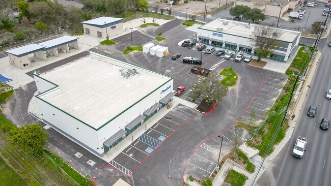
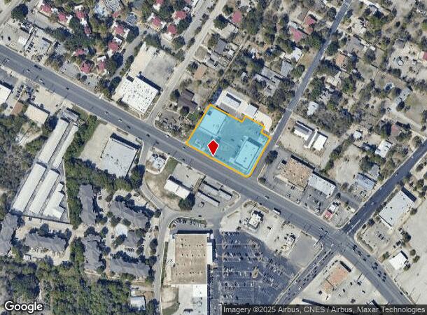
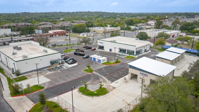
Property Record
1704 Bandera Rd, San Antonio, TX 78228
NEARBY LISTINGS FOR SALE OR LEASE
Property Detail
1704 Bandera Rd
San Antonio-New Braunfels, TX
Ncb 11558 (Snookiells Subd)
11558-700-0770
NCB 11558 BLK G LOT 77 (SNOOKIE 2021 NEW PER PLAT 20001/2528 FILED 9/18/20 CR 50494. JA/GIS/1-14-21
Regionalshoppingcenterormallwithanchorstore
Bexar
X
Texas
48029C0380G
77
2024
1.82 AC
2025
Northwest
180604
San Antonio
17,538 SF
DEMOGRAPHICS near 1704 Bandera Rd
1 Mile
3 Mile
5 Mile
2024 Total Population
14,083
142,132
372,837
2029 Population
14,861
150,455
395,241
Pop Growth 2024-2029
+ 5.52%
+ 5.86%
+ 6.01%
Average Age
39
38
38
2024 Total Households
5,229
55,364
144,494
HH Growth 2024-2029
+ 5.78%
+ 6.14%
+ 6.28%
Median Household Inc
$40,206
$41,561
$44,187
Avg Household Size
2.60
2.50
2.50
2024 Avg HH Vehicles
2.00
2.00
2.00
Median Home Value
$167,215
$154,594
$159,172
Median Year Built
1967
1971
1973
Nearby Places
Map Layers
Map Styles
 Street
 Aerial
- Restaurants
- Banks
- Shops
- Fitness
- Groceries
PUBLIC TRANSPORTATION
COMMUTER RAIL
San Antonio Amtrak Station (Sunset Limited - Amtrak, Texas Eagle - Amtrak)
DRIVE
WALK
Distance
San Antonio Amtrak Station (Sunset Limited - Amtrak, Texas Eagle - Amtrak)
14 min
7.6 mi
AIRPORT
San Antonio International
DRIVE
WALK
Distance
San Antonio International
13 min
9.1 mi
Freight Ports
Calhoun Port
DRIVE
WALK
Distance
Calhoun Port
190 min
155.0 mi
SALE & LEASE HISTORY
LISTING DATE
SALE/LEASE

Aug 08, 2018
For Lease
Nearby Properties
Address
Land Use
TOTAL SIZE
Lot Size
Zoning
Address
Land Use
TOTAL SIZE
Lot Size
Zoning
1,414,945 SF
16.77 AC
Address
Land Use
TOTAL SIZE
Lot Size
Zoning
541,776 SF
22.15 AC
Address
Land Use
TOTAL SIZE
Lot Size
Zoning
97.47 AC
Address
Land Use
TOTAL SIZE
Lot Size
Zoning
278,352 SF
10 AC
Address
Land Use
TOTAL SIZE
Lot Size
Zoning
326,820 SF
12.57 AC
Address
Land Use
TOTAL SIZE
Lot Size
Zoning
227,744 SF
3.99 AC
Address
Land Use
TOTAL SIZE
Lot Size
Zoning
213,968 SF
21.30 AC
Address
Land Use
TOTAL SIZE
Lot Size
Zoning
253,862 SF
14.78 AC
Address
Land Use
TOTAL SIZE
Lot Size
Zoning
495,484 SF
5.81 AC
Address
Land Use
TOTAL SIZE
Lot Size
Zoning
259,934 SF
9.81 AC
Address
Land Use
TOTAL SIZE
Lot Size
Zoning
285,150 SF
13.62 AC
Address
Land Use
TOTAL SIZE
Lot Size
Zoning
340,653 SF
19.27 AC
Address
Land Use
TOTAL SIZE
Lot Size
Zoning
243,251 SF
10 AC
Address
Land Use
TOTAL SIZE
Lot Size
Zoning
221,778 SF
16.31 AC
Address
Land Use
TOTAL SIZE
Lot Size
Zoning
291,385 SF
16.19 AC
Address
Land Use
TOTAL SIZE
Lot Size
Zoning
388,553 SF
29 AC
Address
Land Use
TOTAL SIZE
Lot Size
Zoning
137,036 SF
4.73 AC
Address
Land Use
TOTAL SIZE
Lot Size
Zoning
356,368 SF
18.58 AC
Address
Land Use
TOTAL SIZE
Lot Size
Zoning
291,713 SF
14.51 AC
Address
Land Use
TOTAL SIZE
Lot Size
Zoning
122,292 SF
12.83 AC
Address
Land Use
TOTAL SIZE
Lot Size
Zoning
256,678 SF
4.42 AC
Address
Land Use
TOTAL SIZE
Lot Size
Zoning
86,576 SF
7.84 AC
Address
Land Use
TOTAL SIZE
Lot Size
Zoning
138,674 SF
11.14 AC
Address
Land Use
TOTAL SIZE
Lot Size
Zoning
302,836 SF
15.96 AC
Address
Land Use
TOTAL SIZE
Lot Size
Zoning
207,445 SF
9.55 AC
Address
Land Use
TOTAL SIZE
Lot Size
Zoning
252,361 SF
14.35 AC
Address
Land Use
TOTAL SIZE
Lot Size
Zoning
Address
Land Use
TOTAL SIZE
Lot Size
Zoning
97,800 SF
0.85 AC
Address
Land Use
TOTAL SIZE
Lot Size
Zoning
171,986 SF
6.86 AC
Address
Land Use
TOTAL SIZE
Lot Size
Zoning
311,088 SF
6.89 AC
The World's #1 Commercial Real Estate Marketplace
Connect with us
© 2025 CoStar Group
The information above has been obtained from sources believed reliable. While we do not doubt its accuracy we have not verified it and make no guarantee, warranty or representation about it. It is your responsibility to independently confirm its accuracy and completeness. Any projections, opinions, assumptions, or estimates used are for example only and do not represent the current or future performance of the property. The value of this transaction to you depends on tax and other factors which should be evaluated by your tax, financial, and legal advisors. You and your advisors should conduct a careful, independent investigation of the property to determine to your satisfaction the suitability of the property for your needs.