Property Record
1704 N Country Club Dr, Mesa, AZ 85201
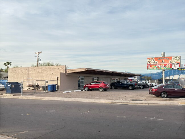

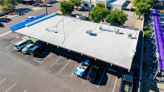
This Property Is For Sale
NEARBY LISTINGS FOR SALE OR LEASE
Property Detail
1704 N Country Club Dr
135-11-007B
BEG AT PT 33 N & 40 W OF SE COR NE4 SE4 NE4 TH N 128F W 135F S 128F TO POB EX E 12F RD & EX 15X15 TRI IN SE COR TH/OF
Storebuilding
Maricopa
X
Arizona
04013C2255L
0.36 AC
2025
Red Mountain/Mesa
2025
Phoenix
421101
Phoenix-Mesa-Scottsdale, AZ
4,902 SF
DEMOGRAPHICS near 1704 N Country Club Dr
1 Mile
3 Mile
5 Mile
2024 Total Population
17,512
95,939
299,871
2029 Population
18,844
102,960
321,989
Pop Growth 2024-2029
+ 7.61%
+ 7.32%
+ 7.38%
Average Age
37
36
36
2024 Total Households
6,458
35,333
116,476
HH Growth 2024-2029
+ 7.65%
+ 7.49%
+ 7.70%
Median Household Inc
$53,333
$54,989
$58,745
Avg Household Size
2.50
2.60
2.50
2024 Avg HH Vehicles
2.00
2.00
2.00
Median Home Value
$287,949
$321,605
$329,650
Median Year Built
1983
1980
1980
Nearby Places
Map Layers
Map Styles
 Street
 Aerial
- Restaurants
- Banks
- Shops
- Fitness
- Groceries
PUBLIC TRANSPORTATION
AIRPORT
Phoenix Sky Harbor International
DRIVE
WALK
Distance
Phoenix Sky Harbor International
16 min
10.7 mi
Phoenix-Mesa Gateway
DRIVE
WALK
Distance
Phoenix-Mesa Gateway
32 min
20.0 mi
Nearby Properties
Address
Land Use
TOTAL SIZE
Lot Size
Zoning
Address
Land Use
TOTAL SIZE
Lot Size
Zoning
8.79 AC
PF
Address
Land Use
TOTAL SIZE
Lot Size
Zoning
197,454 SF
18.97 AC
PF
Address
Land Use
TOTAL SIZE
Lot Size
Zoning
377,442 SF
0.21 AC
C-DT
Address
Land Use
TOTAL SIZE
Lot Size
Zoning
267,023 SF
19.58 AC
PEP
Address
Land Use
TOTAL SIZE
Lot Size
Zoning
485,625 SF
45.99 AC
PF
Address
Land Use
TOTAL SIZE
Lot Size
Zoning
501,927 SF
8.13 AC
GC
Address
Land Use
TOTAL SIZE
Lot Size
Zoning
579,506 SF
17.78 AC
PF
Address
Land Use
TOTAL SIZE
Lot Size
Zoning
407,570 SF
6.22 AC
PEP
Address
Land Use
TOTAL SIZE
Lot Size
Zoning
454,015 SF
10.03 AC
DB1
Address
Land Use
TOTAL SIZE
Lot Size
Zoning
1.46 AC
C-G
Address
Land Use
TOTAL SIZE
Lot Size
Zoning
160,533 SF
7.59 AC
GC
Address
Land Use
TOTAL SIZE
Lot Size
Zoning
478,411 SF
4.07 AC
CDT
Address
Land Use
TOTAL SIZE
Lot Size
Zoning
199,472 SF
4.79 AC
C-DT
Address
Land Use
TOTAL SIZE
Lot Size
Zoning
152,199 SF
21.96 AC
C-G
Address
Land Use
TOTAL SIZE
Lot Size
Zoning
307,038 SF
16.29 AC
M-H
Address
Land Use
TOTAL SIZE
Lot Size
Zoning
79,452 SF
37.59 AC
PF
Address
Land Use
TOTAL SIZE
Lot Size
Zoning
107,519 SF
9.96 AC
M-H
Address
Land Use
TOTAL SIZE
Lot Size
Zoning
169,128 SF
27.30 AC
R-9
Address
Land Use
TOTAL SIZE
Lot Size
Zoning
536,470 SF
28.81 AC
M-H
Address
Land Use
TOTAL SIZE
Lot Size
Zoning
205,331 SF
20.73 AC
C-G
Address
Land Use
TOTAL SIZE
Lot Size
Zoning
97,624 SF
35.57 AC
PF
Address
Land Use
TOTAL SIZE
Lot Size
Zoning
142,260 SF
17.92 AC
PF
Address
Land Use
TOTAL SIZE
Lot Size
Zoning
305,624 SF
18.53 AC
Address
Land Use
TOTAL SIZE
Lot Size
Zoning
126,164 SF
25.41 AC
C-G
Address
Land Use
TOTAL SIZE
Lot Size
Zoning
108,672 SF
1.59 AC
CDT
Address
Land Use
TOTAL SIZE
Lot Size
Zoning
65,192 SF
11.36 AC
C-G
Address
Land Use
TOTAL SIZE
Lot Size
Zoning
92,655 SF
10 AC
R-6
Address
Land Use
TOTAL SIZE
Lot Size
Zoning
403,809 SF
9.68 AC
C-DT
Address
Land Use
TOTAL SIZE
Lot Size
Zoning
203,299 SF
3.63 AC
C-DT
Address
Land Use
TOTAL SIZE
Lot Size
Zoning
167,497 SF
12.08 AC
C-G
The World's #1 Commercial Real Estate Marketplace
Connect with us
© 2026 CoStar Group
The information above has been obtained from sources believed reliable. While we do not doubt its accuracy we have not verified it and make no guarantee, warranty or representation about it. It is your responsibility to independently confirm its accuracy and completeness. Any projections, opinions, assumptions, or estimates used are for example only and do not represent the current or future performance of the property. The value of this transaction to you depends on tax and other factors which should be evaluated by your tax, financial, and legal advisors. You and your advisors should conduct a careful, independent investigation of the property to determine to your satisfaction the suitability of the property for your needs.