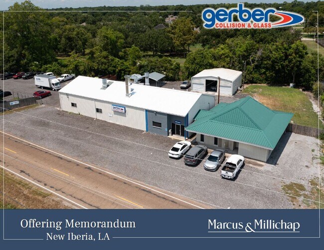
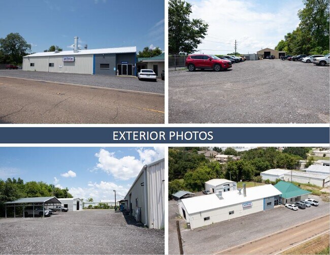
Property Record
1704 S Lillie St, Jeanerette, LA 70544
NEARBY LISTINGS FOR SALE OR LEASE
Property Detail
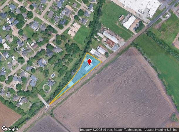
1704 S Lillie St
0200661000
1.40 AC.. ITEM 2 PATTON, PESSON, LEWIS ST, CANAL LOCATED IN SEC 35 T 12 S R 6 E. WORK SHOP (BLDG 1) ITEM 1 OFFICE (BLDG 2) IT
Commercialnec
Iberia
AE
Louisiana
22045C0202E
1.40 AC
2024
Louisiana South Area
2024
Other Market Areas
031600
Lafayette, LA
DEMOGRAPHICS near 1704 S Lillie St
1 Mile
3 Mile
5 Mile
2024 Total Population
4,108
30,148
45,099
2029 Population
3,989
29,402
43,652
Pop Growth 2024-2029
(2.90%)
(2.47%)
(3.21%)
Average Age
41
40
40
2024 Total Households
1,704
11,968
17,616
HH Growth 2024-2029
(2.76%)
(2.29%)
(3.02%)
Median Household Inc
$38,437
$42,253
$48,121
Avg Household Size
2.30
2.40
2.50
2024 Avg HH Vehicles
1.00
2.00
2.00
Median Home Value
$109,077
$134,591
$148,016
Median Year Built
1973
1971
1975
Nearby Places
Map Layers
Map Styles
 Street
 Aerial
- Restaurants
- Banks
- Shops
- Fitness
- Groceries
PUBLIC TRANSPORTATION
COMMUTER RAIL
New Iberia Amtrak (Sunset Limited - Amtrak)
DRIVE
WALK
Distance
New Iberia Amtrak (Sunset Limited - Amtrak)
6 min
3.2 mi
AIRPORT
Lafayette Regional/Paul Fournet Field
DRIVE
WALK
Distance
Lafayette Regional/Paul Fournet Field
28 min
22.6 mi
Freight Ports
Port of Iberia
DRIVE
WALK
Distance
Port of Iberia
7 min
2.9 mi
SALE & LEASE HISTORY
LISTING DATE
SALE/LEASE

Aug 26, 2024
For Sale
Nearby Properties
Address
Land Use
TOTAL SIZE
Lot Size
Zoning
Address
Land Use
TOTAL SIZE
Lot Size
Zoning
Address
Land Use
TOTAL SIZE
Lot Size
Zoning
10.84 AC
Address
Land Use
TOTAL SIZE
Lot Size
Zoning
Address
Land Use
TOTAL SIZE
Lot Size
Zoning
Address
Land Use
TOTAL SIZE
Lot Size
Zoning
Address
Land Use
TOTAL SIZE
Lot Size
Zoning
Address
Land Use
TOTAL SIZE
Lot Size
Zoning
Address
Land Use
TOTAL SIZE
Lot Size
Zoning
Address
Land Use
TOTAL SIZE
Lot Size
Zoning
39.99 AC
Address
Land Use
TOTAL SIZE
Lot Size
Zoning
Address
Land Use
TOTAL SIZE
Lot Size
Zoning
Address
Land Use
TOTAL SIZE
Lot Size
Zoning
Address
Land Use
TOTAL SIZE
Lot Size
Zoning
20.36 AC
Address
Land Use
TOTAL SIZE
Lot Size
Zoning
Address
Land Use
TOTAL SIZE
Lot Size
Zoning
Address
Land Use
TOTAL SIZE
Lot Size
Zoning
Address
Land Use
TOTAL SIZE
Lot Size
Zoning
Address
Land Use
TOTAL SIZE
Lot Size
Zoning
9.02 AC
Address
Land Use
TOTAL SIZE
Lot Size
Zoning
Address
Land Use
TOTAL SIZE
Lot Size
Zoning
Address
Land Use
TOTAL SIZE
Lot Size
Zoning
Address
Land Use
TOTAL SIZE
Lot Size
Zoning
13.84 AC
Address
Land Use
TOTAL SIZE
Lot Size
Zoning
Address
Land Use
TOTAL SIZE
Lot Size
Zoning
Address
Land Use
TOTAL SIZE
Lot Size
Zoning
Address
Land Use
TOTAL SIZE
Lot Size
Zoning
Address
Land Use
TOTAL SIZE
Lot Size
Zoning
Address
Land Use
TOTAL SIZE
Lot Size
Zoning
Address
Land Use
TOTAL SIZE
Lot Size
Zoning
Address
Land Use
TOTAL SIZE
Lot Size
Zoning
The World's #1 Commercial Real Estate Marketplace
Connect with us
© 2025 CoStar Group
The information above has been obtained from sources believed reliable. While we do not doubt its accuracy we have not verified it and make no guarantee, warranty or representation about it. It is your responsibility to independently confirm its accuracy and completeness. Any projections, opinions, assumptions, or estimates used are for example only and do not represent the current or future performance of the property. The value of this transaction to you depends on tax and other factors which should be evaluated by your tax, financial, and legal advisors. You and your advisors should conduct a careful, independent investigation of the property to determine to your satisfaction the suitability of the property for your needs.