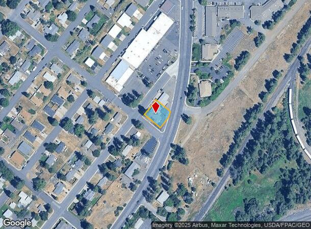
Property Record
1705 2Nd St, Cheney, WA 99004
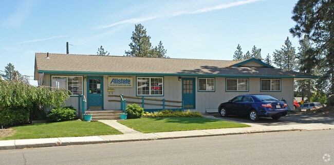
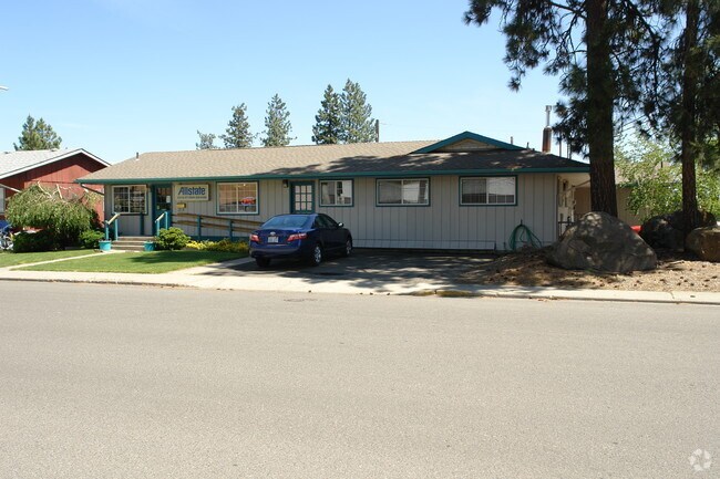
This Property Is For Sale
Current Lease Availabilities
NEARBY LISTINGS FOR SALE OR LEASE
Property Detail
1705 2Nd St
Spokane-Spokane Valley, WA
Cheney Callaways Add
13124.4203
CHENEY CALLAWAYS ADD TO CALLAWAYS ADD TO THE TOWN OF LTS 4 & 5 BLK 26 LESS HWY TOG W/ N1/2 OF VAC ALLEY LYG SLY & ADJ TO
Financialbuilding
Spokane
X
Washington
53063C0852D
4,5
2025
0.24 AC
2025
West Plains
014001
Spokane
2,606 SF
DEMOGRAPHICS near 1705 2Nd St
1 mile
3 mile
5 mile
2024 Total Population
8,589
15,014
17,016
2029 Population
9,198
16,026
18,136
Pop Growth 2024-2029
+ 7.09%
+ 6.74%
+ 6.58%
Average Age
31
32
33
2024 Total Households
3,000
5,658
6,406
HH Growth 2024-2029
+ 7.97%
+ 7.26%
+ 7.07%
Median Household Inc
$38,539
$44,235
$50,278
Avg Household Size
2.20
2.30
2.30
2024 Avg HH Vehicles
2.00
2.00
2.00
Median Home Value
$291,157
$302,187
$337,521
Median Year Built
1980
1985
1986
Nearby Places
Map Layers
Map Styles
 Street
 Aerial
Transit
 Traffic
 Biking
Places
Listings with unknown addresses are not visible on the map
- Restaurants
- Banks
- Shops
- Fitness
- Groceries
PUBLIC TRANSPORTATION
AIRPORT
Spokane International
Drive
Walk
Distance
Spokane International
19 min
12.6 mi
Nearby Properties
Address
Land Use
TOTAL SIZE
Lot Size
Zoning
Address
Land Use
TOTAL SIZE
Lot Size
Zoning
410,897 SF
4.38 AC
P
Address
Land Use
TOTAL SIZE
Lot Size
Zoning
375,519 SF
16.62 AC
P
Address
Land Use
TOTAL SIZE
Lot Size
Zoning
265,676 SF
25.25 AC
R-1
Address
Land Use
TOTAL SIZE
Lot Size
Zoning
182,817 SF
13.20 AC
R-3
Address
Land Use
TOTAL SIZE
Lot Size
Zoning
312,332 SF
4.06 AC
P
Address
Land Use
TOTAL SIZE
Lot Size
Zoning
249,952 SF
19.34 AC
R-3
Address
Land Use
TOTAL SIZE
Lot Size
Zoning
228,269 SF
9.43 AC
P
Address
Land Use
TOTAL SIZE
Lot Size
Zoning
196,902 SF
17.05 AC
P
Address
Land Use
TOTAL SIZE
Lot Size
Zoning
61,142 SF
13 AC
R-3H
Address
Land Use
TOTAL SIZE
Lot Size
Zoning
68,755 SF
100 AC
P
Address
Land Use
TOTAL SIZE
Lot Size
Zoning
129,310 SF
34.99 AC
R-1
Address
Land Use
TOTAL SIZE
Lot Size
Zoning
165,284 SF
1.65 AC
P
Address
Land Use
TOTAL SIZE
Lot Size
Zoning
142,588 SF
9.16 AC
R-3
Address
Land Use
TOTAL SIZE
Lot Size
Zoning
106,944 SF
1.89 AC
R-3H
Address
Land Use
TOTAL SIZE
Lot Size
Zoning
46,761 SF
3.09 AC
P
Address
Land Use
TOTAL SIZE
Lot Size
Zoning
66,489 SF
2.34 AC
P
Address
Land Use
TOTAL SIZE
Lot Size
Zoning
33,440 SF
2.59 AC
P
Address
Land Use
TOTAL SIZE
Lot Size
Zoning
109,528 SF
4.17 AC
R-3
Address
Land Use
TOTAL SIZE
Lot Size
Zoning
202,449 SF
23.29 AC
I-1
Address
Land Use
TOTAL SIZE
Lot Size
Zoning
49,872 SF
1.88 AC
P
Address
Land Use
TOTAL SIZE
Lot Size
Zoning
40,361 SF
2.54 AC
C-2
Address
Land Use
TOTAL SIZE
Lot Size
Zoning
55,047 SF
1.26 AC
R-3H
Address
Land Use
TOTAL SIZE
Lot Size
Zoning
81,628 SF
11.88 AC
C-2
Address
Land Use
TOTAL SIZE
Lot Size
Zoning
40,541 SF
3.85 AC
R-3H
Address
Land Use
TOTAL SIZE
Lot Size
Zoning
97,585 SF
0.57 AC
P
Address
Land Use
TOTAL SIZE
Lot Size
Zoning
74,769 SF
2.11 AC
P
Address
Land Use
TOTAL SIZE
Lot Size
Zoning
95,120 SF
4 AC
R-3
Address
Land Use
TOTAL SIZE
Lot Size
Zoning
71,708 SF
4.35 AC
R-3H
Address
Land Use
TOTAL SIZE
Lot Size
Zoning
19,088 SF
2.19 AC
P
Address
Land Use
TOTAL SIZE
Lot Size
Zoning
68,008 SF
4.64 AC
R-3H
The World's #1 Commercial Real Estate Marketplace
Connect with us
© 2026 CoStar Group
The information above has been obtained from sources believed reliable. While we do not doubt its accuracy we have not verified it and make no guarantee, warranty or representation about it. It is your responsibility to independently confirm its accuracy and completeness. Any projections, opinions, assumptions, or estimates used are for example only and do not represent the current or future performance of the property. The value of this transaction to you depends on tax and other factors which should be evaluated by your tax, financial, and legal advisors. You and your advisors should conduct a careful, independent investigation of the property to determine to your satisfaction the suitability of the property for your needs.